
Written By Dock Line Magazine Investigation Desk
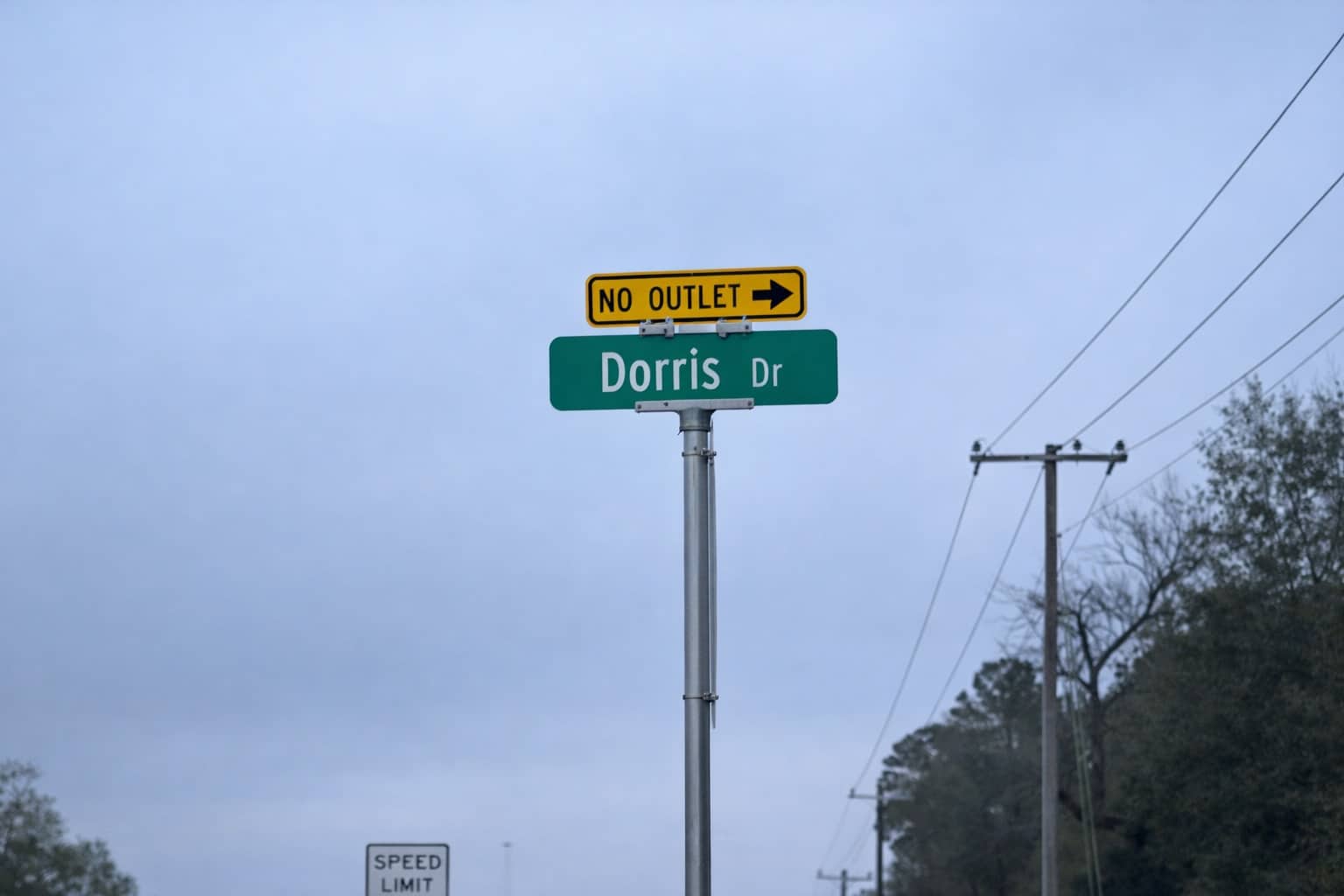
In the quiet stretches of West County, where the established Woodland Lakes community meets the newly developed Williams Trace, a small stretch of pavement known as Dorris Drive (recorded variously as Doris Dr. and Dorris Ln.) has become the focal point of a growing controversy.
For decades, Dorris Drive was a quiet, single-lane gravel road serving approximately 10 homes. Today, following the rapid expansion of the adjacent Williams Trace subdivision, residents warn that this same narrow infrastructure is now shouldering the traffic potential of an additional 577 households.
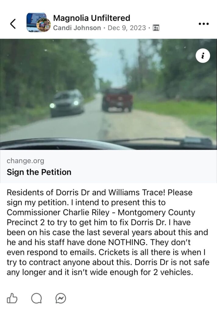
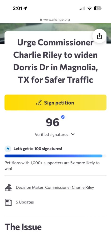
Armed with county records, video evidence, and a petition signed by 96 neighbors, residents have continuously been asking the Montgomery County Precinct 2 Commissioner’s Office a vital question: Was the safety and capacity of Dorris Drive considered before the floodgates of development were opened?
The Mathematics of Capacity
The central concern is a matter of numbers. Prior to 2018, the road served a handful of residents. However, Commissioner’s Court minutes paint a picture of rapid expansion without corresponding infrastructure upgrades.
- February 13, 2018: Williams Trace Section 1 is finalized (121 lots).
- October 9, 2018: Section 2 is approved (238 lots), designating Angelico Road as a secondary exit that feeds directly onto Dorris Drive.
- April 27, 2021: Section 3 is approved (218 lots).
Residents point out that while the housing count skyrocketed from 10 to nearly 600, Dorris Drive remains a single-lane road. While it has since been paved, visual inspection reveals a road struggling to maintain integrity, with layers of pavement visible and dangerous 3-to-6-inch drop-offs into ditches on either side in spots.
This disparity raises a fundamental question for Precinct 2: During the approval process for Williams Trace Sections 2 and 3, was a traffic impact analysis conducted regarding the load-bearing capacity and width of Dorris Drive?
The “Standoff” on FM 1488
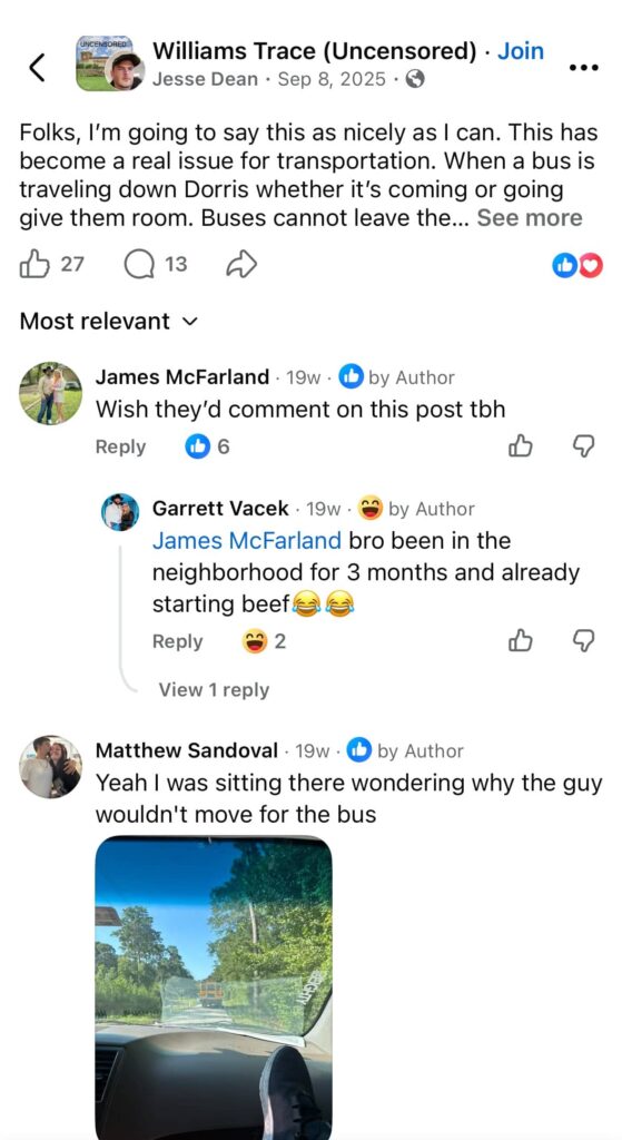
The physical limitations of the road have created a daily hazard. Because the road is too narrow for two cars to pass safely without one pulling into the ditch, “standoffs” are common.
Residents report that traffic frequently stacks up on the high-speed FM 1488, waiting for the single lane of Dorris Drive to clear. Conversely, when a driver turns from Angelico onto Dorris toward FM 1488, they often encounter incoming traffic. With nowhere to go, one vehicle is forced to back up—sometimes all the way down the street—or risk vehicle damage by pulling off the pavement into a deep drop-off.
School Buses and Student Safety
Perhaps the most alarming concerns come from the intersection of infrastructure and education. According to an employee of the Magnolia Independent School District (MISD), the district utilizes the Versitrans GPS system to monitor bus routes. Currently, both the standard route for Williams Trace and a Special Education (SPED) bus utilize Dorris Drive.
The dilemma is legal as well as logistical. It is reportedly illegal for school buses to leave the pavement. With a one-lane road and two-way traffic, bus drivers face impossible choices. Residents have documented delays caused by vehicles unable to pass the bus. Furthermore, the SPED bus, having no turnaround at the end of the route, is forced to back down the road to execute a turnaround at the Angelico Street entrance—a maneuver that parents fear is a tragedy waiting to happen.
The community asks: Is the county aware that school buses are being forced into unsafe maneuvers due to the road’s width, and are there plans to widen the road to meet MISD safety standards?
Emergency Access and Fire Hazards
The dangers extend beyond school runs. The area has seen multiple fires in the last five years. With no accessible water source, tankers must attend these calls. The dilapidated state of the road raises concerns about its ability to support the weight of heavy emergency apparatus. Furthermore, like the school buses, emergency vehicles face a lack of turnaround space, potentially requiring them to back down the length of the road to exit.
Drainage and Flood History
Dorris Drive sits in a historically flood-prone area, notably during the major floods of 1994. While the new development plans included drainage proposals, residents on Dorris Drive claim the reality has been different.
One resident noted that it took extreme measures—including a desperate call to a Commissioner’s family member—to get the county to address water actively routing under an elderly neighbor’s home. While a concrete drainage ditch has since been installed near the start of the road, questions remain about its efficacy given the creek running adjacent to the road.
The inquiry for the County Engineer is clear: Does the current drainage solution account for the cumulative runoff of the fully developed Williams Trace neighborhood, and has the integrity of the creek bank been assessed since the increase in pavement?
A Call for Assessment
This is not a matter of opposing development, but of ensuring infrastructure keeps pace with progress. The residents of Dorris Drive, both old and new, have provided emails dating back to 2018, photos of deteriorating pavement, and signed petitions.
They are not asking for a halt to progress; they are asking for a road that is safe to drive, safe for their children’s buses, and accessible for emergency vehicles.
A Statistical Warning Sign
While the condition of Dorris Drive itself is a point of contention, the intersection where it meets FM 1488 has become a documented hazard zone. Residents describe pulling out onto the 5-lane highway as a “leap of faith,” citing poor visibility and structural obstructions.
The data supports their fears. According to TxDOT reporting, accident frequency in this specific stretch has risen sharply alongside the development of the area.
- Pre-2018: The area averaged approximately 2 accidents annually.
- Post-2018: Accident rates have steadily climbed, with recent years showing a staggering spike to 9 accidents annually in this small stretch of roadway.
The Anatomy of a Blind Spot The danger stems from the physical geometry of the intersection. Dorris Drive sits significantly lower than the grade of FM 1488. When motorists attempt to exit the neighborhood, they are flanked on both sides by guardrails and bridge infrastructure that obscure the view of oncoming traffic traveling at highway speeds.
Drivers report that to see past the guardrails, they must inch their vehicles dangerously close to the active lanes of FM 1488. With the road serving as a primary exit for hundreds of new families—many of whom may include inexperienced teenage drivers—the margin for error has vanished.
We invite the Montgomery County Commissioner Precinct 2’s Office to review the provided materials and join the residents for an on-site inspection of Dorris Drive.
Key Questions for Commissioner Precinct 2:
- Are there current plans to widen Dorris Drive to a standard two-lane county road?
- Can the office confirm if the road base is rated for the weight of fully loaded fire tankers and school buses?
- Will the county review the drainage placement in relation to the adjacent creek to prevent a recurrence of the 1994 flood levels?
- With a 350% increase in accident frequency in this specific zone, is there an active plan to regrade the intersection or install warning sensors to alert exiting drivers of oncoming traffic?
Evidence and Images on the issue: