El Niño Just Flipped the Weather Outlook Upside Down
What it means to you depends on where you live
Every few years, two Spanish words begin appearing in weather reports across America:
El Niño.
Before long, those words are blamed for rain, drought, warm winters, heavy snow, rough seas, crop problems, disappointing ski seasons, and almost anything else the atmosphere has done without first asking permission.
But El Niño is not a storm.
It does not receive a name, form offshore, and arrive over your town on Tuesday afternoon.
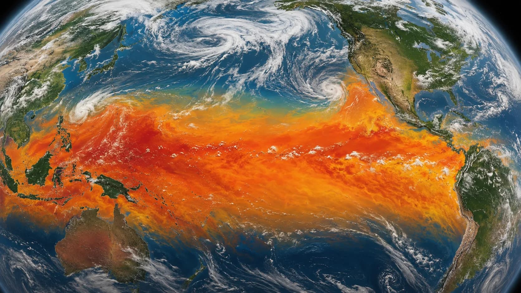
El Niño begins thousands of miles away in the tropical Pacific Ocean. A broad area of surface water becomes warmer than usual, the atmosphere above it responds, and weather patterns around the world begin shifting.
It is almost as though the Pacific Ocean reached across the table and flipped the weather outlook upside down.
The pieces do not land the same way everywhere.

What El Niño means to you depends largely on where you live.
What El Niño means to you depends largely on where you live.
What Exactly Is El Niño?
Under normal conditions, trade winds blow from east to west across the tropical Pacific. Those winds help push warm surface water toward Indonesia and the western Pacific while allowing colder, nutrient-rich water to rise near the western coast of South America.
During El Niño, those trade winds weaken and may occasionally reverse. Warmer water spreads eastward across the central and eastern tropical Pacific, and the main area of tropical rainfall moves with it.
That change can influence large atmospheric circulation patterns and alter the position and strength of the jet streams - the fast-moving rivers of air high above Earth that steer storms and help separate warm air from cold air.
Think of the Pacific Ocean as an enormous part of Earth's heating and ventilation system.
Change the temperature in one important section, and weather patterns elsewhere may begin moving the furniture.
El Niño and its cooler counterpart, La Niña, are opposite phases of a natural cycle called the El Niño-Southern Oscillation, commonly shortened to ENSO. The cycle shifts irregularly every two to seven years and is one of the most influential natural drivers of year-to-year climate variability.

El Niño changes the odds. It does not personally schedule the rain at your house.
Why Are We Hearing About It Now?
Because El Niño is not merely something forecasters think might happen someday.
It is happening now.
NOAA's July 9, 2026 monthly update reported that El Niño was strengthening. The agency estimated a 97% chance that it would continue through early spring 2027 and an 81% chance of becoming a very strong event during October through December 2026. NOAA also cautioned that even the strongest El Niño events do not produce every typical effect in every location.
The World Meteorological Organization expects the event to strengthen rapidly and has warned that it may increase the likelihood of heat waves, drought, heavy rainfall, and other extreme weather in vulnerable parts of the world.
That does not mean every dramatic weather event during the coming months should be blamed on El Niño.
Other ocean patterns, local geography, short-term atmospheric changes, and ordinary weather variability still matter.
El Niño changes the odds.
It does not personally schedule the rain at your house.

The global pattern tells you the Pacific is changing. Local forecasts tell you what to do.
What El Niño Means to You Depends on Where You Live
El Niño does not prepare one weather package and leave an identical box on every doorstep.
A family in Texas may experience a different seasonal tendency from someone in Washington. A California water manager may be watching for winter storms, while a ski area in the northern Rockies may be concerned about warmth and snowpack.
The Pacific may be making the adjustment, but geography determines where many of the pieces land.
Texas, the Gulf Coast, and the Southeast
During many El Niño winters, the Pacific jet stream becomes stronger, extends farther east, and shifts southward across the United States.
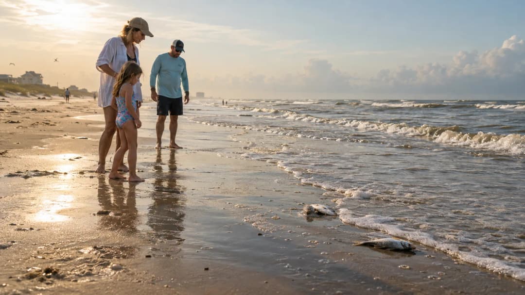
That pattern often increases the odds of cooler and wetter winter conditions across parts of the southern United States, particularly along the Gulf Coast from Texas through Florida. Wetter-than-average conditions along the Gulf Coast are among the more reliable American El Niño signals.
That does not guarantee months of nonstop rain.
It means the background pattern may favor more precipitation and storm activity than usual.
In Texas, the rain gauge may receive more exercise while everyone continues debating whether 45 degrees qualifies as a serious winter emergency.
Residents should watch local flood risks, road conditions, agricultural forecasts, and seasonal water-management decisions rather than assuming 'wetter' automatically means beneficial.
Rain arriving gently over several weeks is useful.
The same amount arriving before lunch may have other plans.
California and the Southwest
El Niño can strengthen the southern storm track and improve the odds of winter rain and mountain snow across portions of California and the Southwest.
The relationship is not automatic, however. The rainfall signal in California and the Southwest depends considerably on the strength of the El Niño event. Some strong El Niños have produced extremely wet winters; others have delivered much less than expected.
El Niño can improve the chances of rain.
It cannot be placed under contract to deliver the correct amount, to the correct county, on the correct day, and stop before producing floods, erosion, or mudslides.
A wet winter may improve reservoirs and snowpack in some areas. It may also create travel problems, property damage, or dangerous runoff.
The phrase 'more likely' still matters.
The Pacific Northwest and Northern Rockies
The Pacific Northwest and portions of the northern Rockies often lean warmer and drier during an El Niño winter because the primary storm track tends to shift farther south.
That can matter to ski areas, farmers, water managers, power utilities, and communities that depend on mountain snowpack.
Warmer and drier does not mean rain and snow disappear.
A mild winter can still produce a powerful storm and at least one morning when everyone stands beside the car wondering why the doors are frozen shut.
Seasonal averages describe the entire winter.
They do not cancel individual bad Tuesdays.
The Northern States and Great Lakes
Large parts of the northern United States often experience a warmer-than-average winter tendency during El Niño. Snowfall may also be reduced across portions of the Great Lakes, northern Rockies, Pacific Northwest, and interior New England.
But warmer than average does not mean warm.
It may simply mean the entire winter averages a few degrees above normal after all the unusually cold mornings, mild afternoons, snowstorms, thaws, refreezes, and arguments with the driveway are combined.
Northern residents should not donate the snow shovel based on one seasonal outlook.
Winter has a sense of humor and does not appreciate being underestimated.
Ohio and the Tennessee Valley
The Ohio Valley and portions of the Tennessee Valley have often leaned drier during El Niño winters. Parts of the Great Lakes region may also receive less snow than usual.
That does not grant Ohio immunity from snow, ice, cold fronts, or anything Lake Erie decides to contribute.
It means that when the entire season is measured, precipitation may be more likely to finish below normal.
A seasonal outlook tells you the general direction of the trip.
It does not identify every pothole.
The Atlantic and Gulf Hurricane Regions
El Niño can influence hurricane activity as well.
It commonly increases vertical wind shear across the tropical Atlantic. Vertical wind shear occurs when winds change speed or direction at different heights in the atmosphere. Strong shear can disrupt thunderstorms before they organize into tropical storms and hurricanes.
NOAA's 2026 Atlantic hurricane outlook assigned the greatest probability to a below-normal season, with developing El Niño conditions among the important reasons.
That does not make the Atlantic or Gulf Coast hurricane-proof.
A quieter season can still produce a destructive landfall.
Statistics are not particularly comforting when the one storm that does form is approaching your house.
El Niño may reduce the overall odds of Atlantic activity while creating more favorable conditions for tropical cyclones in portions of the eastern and central Pacific.
Again, the weather board has been flipped.
The pieces did not disappear.
They moved.
El Niño Does Not Stop at the U.S. Border
El Niño begins in the tropical Pacific, but it has never been especially interested in minding its own business.
The movement of warm water, tropical thunderstorms, and rising air can trigger atmospheric connections that influence rainfall and temperature thousands of miles away.
Parts of coastal western South America, including Peru and Ecuador, may experience heavier rainfall and increased flooding risk.
Australia, Indonesia, and portions of southern Asia may become more vulnerable to dryness, drought, heat, and wildfire conditions.
Agricultural regions elsewhere may receive too much rain - or not nearly enough.
Those changes can affect:
Crops and food prices
Drinking-water supplies
Hydroelectric power
Wildfire conditions
Fisheries
Public health
Transportation
Disaster response
El Niño can also disrupt marine ecosystems. Warmer water and weaker upwelling near South America can reduce the supply of cold, nutrient-rich water that supports fish populations, affecting fishing communities and regional economies.
One region may face flooding.
Another may face drought.
A farmer, fisherman, utility company, shipping business, and family planning a vacation can all experience the same global climate pattern in very different ways.
Does El Niño Make the Whole World Warmer?
El Niño can temporarily raise the global average temperature because heat stored in the tropical Pacific Ocean is transferred more readily into the atmosphere.
It does not cause long-term climate change, but it occurs on top of the planet's longer-term warming trend. The combination can increase the likelihood of unusually high temperatures and contribute to dangerous heat in some regions.
In other words, El Niño is not the whole climate story.
It is one very influential chapter - and it sometimes arrives carrying a highlighter.
What El Niño Does Not Mean
El Niño has become so familiar that it occasionally gets blamed for almost everything.
A thunderstorm appears.
El Niño.
December feels unusually warm.
El Niño.
Someone's tomato plants look unhappy.
Probably El Niño.
But individual storms and daily weather events cannot usually be labeled 'an El Niño storm.'
El Niño changes broad patterns, seasonal tendencies, and probabilities. It does not create every strange afternoon or control every local weather system.
It also does not mean:
Every southern state will be wet.
Every northern state will be warm.
California will automatically flood.
The Atlantic will have no hurricanes.
Ohio can sell its snowplows.
Every expected regional effect will appear.
Each El Niño event develops differently.
Other climate patterns continue operating at the same time, and the atmosphere retains its long-standing right to ignore everyone's expectations.
El Niño Loads the Weather Dice
The simplest way to understand El Niño is through probability.
Imagine that ordinary seasonal weather is represented by a standard six-sided die.
El Niño does not choose which number appears.
It changes the weighting.
Certain outcomes become more likely. Others become less likely. Several possibilities remain.
That is why meteorologists use phrases such as:
Increased odds.
Greater likelihood.
Warmer than average.
Wetter than normal.
Seasonal tendency.
They are not avoiding the question.
They are describing what the science can honestly tell us.
A seasonal outlook is not a daily forecast stretched across three months.
Why Ordinary People Should Care
Most people do not need to become oceanographers.
But understanding El Niño helps explain why farmers, utilities, water managers, emergency agencies, insurance companies, health officials, ports, and transportation businesses begin preparing months in advance.
A wetter southern winter may affect planting decisions and flood preparation.
A warmer northern winter may reduce heating demand while hurting snow-dependent businesses.
Dry conditions overseas may reduce crop production and influence food prices.
Changed ocean temperatures may affect commercial fishing.
Different hurricane odds may change emergency planning on two separate coasts.
The World Meteorological Organization emphasizes early warning because even an imperfect seasonal forecast can help governments and communities protect lives, water supplies, crops, infrastructure, and livelihoods.
A smoke detector cannot promise there will be a fire.
It is still worth installing.
What Should You Do With This Information?
Treat national El Niño headlines as background - not as the final word about your hometown.
Watch the risks that matter where you live:
Flooding and heavy rain
Drought and water restrictions
Heat
Snowpack and winter travel
Wildfire conditions
Hurricanes
Agricultural conditions
Coastal and marine weather
Follow local National Weather Service offices, regional climate specialists, and emergency-management agencies.
The global pattern tells you that the Pacific is changing.
Your local meteorologist tells you whether to move the lawn chairs.
The Bottom Line
El Niño is not a storm, a weather villain, or a guarantee.
It is a large natural shift in the tropical Pacific Ocean that can influence winds, rainfall, temperatures, hurricanes, agriculture, fisheries, and seasonal weather thousands of miles away.
NOAA says the current El Niño is strengthening and is highly likely to continue into early spring 2027. It may become one of the strongest events recorded since modern monitoring began in 1950 - but even a powerful El Niño cannot force every region to follow the usual script.
What it means to you depends on where you live.
Texas and the Gulf Coast may lean wetter.
California and the Southwest may watch the southern storm track.
The Pacific Northwest and northern Rockies may watch warmth and snowpack.
The Great Lakes and Ohio Valley may lean warmer or drier while remaining entirely capable of producing winter.
Atlantic hurricane activity may be suppressed while portions of the Pacific become more active.
Around the world, communities may prepare for too much water, too little water, unusual heat, disrupted crops, or changing fisheries.
El Niño changes the odds.
It does not write tomorrow's forecast.
But when the largest ocean on Earth begins moving heat and moisture differently, paying attention is usually a pretty good idea.
The Pacific may be thousands of miles from your front door.
That does not mean it cannot reach the weather outside it.
Dock Line Tip — Treat national El Niño headlines as background, not your local forecast. Follow your National Weather Service office for the risks that matter where you live.