The History of Anahuac, Texas
Anahuac, Texas (ZIP 77514) began as a Mexican customs fort on Trinity Bay in 1830, where the jailing of William B. Travis set off fighting in 1832. Thomas Jefferson Chambers, who fought over the townsite for decades, was shot through his parlor window in 1865; the marker on his house says 1863.
Editor’s note. This is the thirtieth installment of “Texas Towns: The Stories Behind the Map.” The last one went to Calvert, a Brazos prairie town built by a railroad. This one goes to the coast, to a bluff over Trinity Bay that no railroad story explains. Readers of our Gonzales installment will remember the cannon the colonists would not give back in October 1835. Three years before that, and again that same summer, the trouble had already boiled over at a Mexican customs post called Anahuac. This is that town.
Anahuac, Texas, sits on the northeast bank of Trinity Bay where the Trinity River enters it, on State Highway 61 about five miles south of Interstate 10 in western Chambers County. It is the county seat. The Handbook of Texas puts Lake Anahuac, the old Turtle Bay that wraps the north side of town, forty-five miles east of Houston. The Handbook’s account of the town mentions no railroad at all; for most of its history the road to Anahuac was the water. The mailing ZIP is 77514. [1] [12] [24] [4]
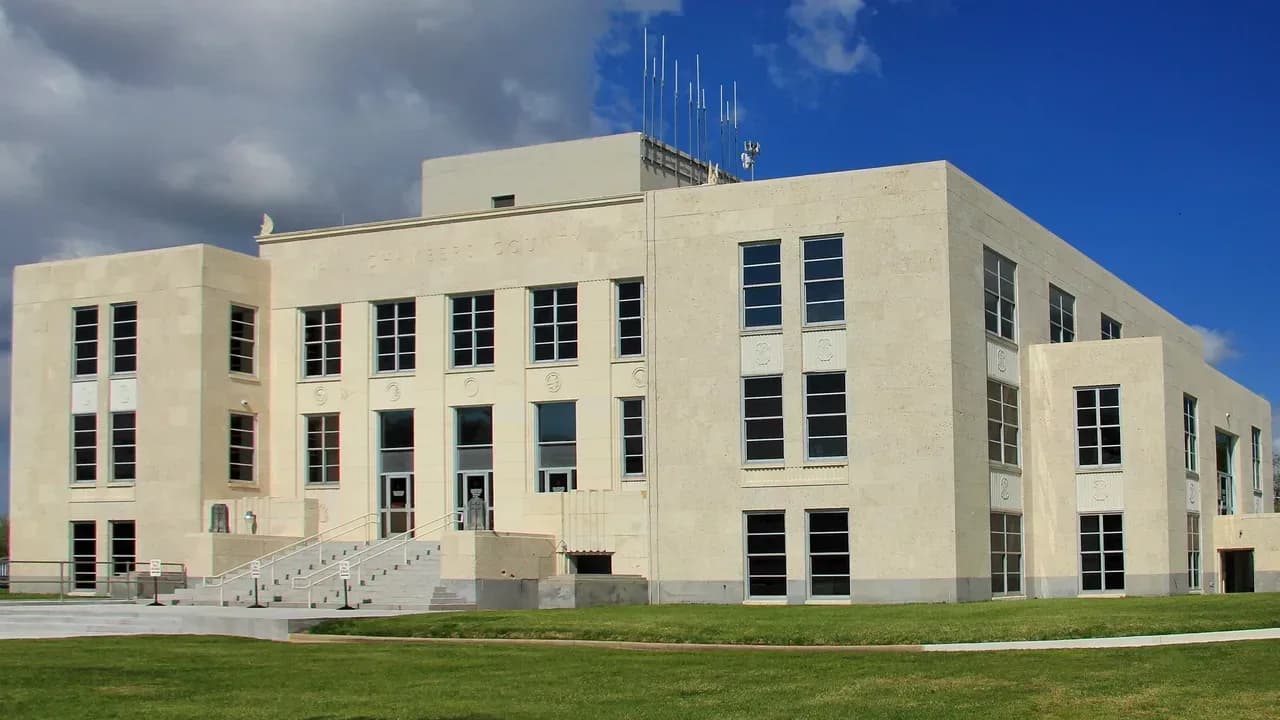
A driver coming down Highway 61 today sees a small courthouse town: a pale limestone courthouse of 1937, a few blocks of houses, rice country on the flats around it, and, a mile south on the bluff, a county park with live oaks and a cluster of state historical markers. There is almost nothing left to see of the brick fort that stood there. What happened at that fort in 1832 and 1835 is the reason most Texans have heard the name, but the town also carries a long land fight, a murder, an assassination, slavery and its aftermath, a rice canal, two burned courthouses and a county that nearly dissolved itself. This article tells it the way the record does, and says so when the record disagrees with itself. [1] [3] [33] [38]
Before 1830: Atakapans, Perry’s Point and the filibusters
The Handbook’s town entry says the earliest inhabitants of the Anahuac area were Atakapan Indians, and that in 1721 the French explorer Jean Baptiste de La Harpe visited a village of some 200 Atakapans between the future townsite and Round Point. La Harpe’s own Handbook entry says he sailed into Galveston Bay on August 27, 1721, believing it was the place he had been sent to settle. The courthouse’s National Register nomination names Karankawa, Coapite and Copane people as living in the area when the first European expeditions came up the lower Trinity. [1] [13] [33]
The Spanish answered French traders on the lower Trinity with an outpost called El Orcoquisac, a presidio and a mission near the site of present Wallisville, north of Anahuac, from 1756 to 1771. Its missionaries worked among the Orcoquiza and Bidai people. By the early 1800s, the county entry says, Alabama and Coushatta Indians had moved into the region and absorbed the local Bidais and Orcoquizas. The record here is mostly the record of the newcomers; the Handbook does not say what became of the Atakapan village La Harpe saw. [15] [4]
The bluff got its first English name from a filibuster. Henry Perry, a Connecticut-born veteran of the Gutiérrez-Magee expedition, raised volunteers in Louisiana in 1815 for another attack on Spanish Texas. After one of his schooners foundered at the entrance to Galveston Bay and sixty men drowned, Perry moved his men inland to a wooded rise over the mouth of the Trinity. The town entry dates his camp to 1816; Perry’s own entry says he abandoned the point about March 1816 and joined Luis Michel Aury on Galveston Island. Either way, the place was called Perry’s Point for years afterward. John Davis Bradburn, who would come back as the Mexican commander, was then one of the men funneling supplies to Perry. [8] [1] [7]
The county entry places a colony of exiled Napoleonic officers under Charles Lallemand near the site of present Anahuac in 1818. Lallemand’s own Handbook entry puts that colony, Champ d’Asile, up the Trinity at Atascosito, nearer present Liberty, and says the exiles fled to Galveston about July 24, 1818. We print both. Settlement of a more lasting kind followed Mexican independence: most of what is now Chambers County fell within Joseph Vehlein’s empresario grant, and in 1828 James Taylor White drove a herd of longhorn cattle along the Opelousas Road from Louisiana and settled near Turtle Bayou, north of the bluff. [4] [14] [17] [40]
1830–1831: Bradburn’s fort and a Mexican town
On October 26, 1830, Col. Juan Davis Bradburn landed at Perry’s Point with about forty officers and men and orders to build a garrison and a town. Bradburn was Virginia-born and had come to Mexico as a filibuster, then risen as an officer in the Mexican army. His post was one of six new garrisons placed at the entrances to Texas to enforce the Law of April 6, 1830, which aimed to encourage Mexican and European settlement and to restrict immigration from the United States. It was also to prevent smuggling and to support the customs collector, George Fisher, who arrived in November 1831. [2] [7] [3]
The name is a point of disagreement. The Handbook says Gen. Manuel de Mier y Terán officially named the town Anahuac in January 1831, after the ancient seat of the Aztecs. The 1976 state marker at the fort says the place was “known as Perry’s Point until 1825,” and the county entry likewise says Perry’s Point was renamed Anahuac in 1825. Perry’s own entry says the name Perry’s Point lasted “through 1830.” The 1936 marker on the same ground credits the fort and its name to Mier y Terán in 1830. [1] [18] [4] [8] [19]
Bradburn brought plans and, the Handbook says, a cardboard model of the fort. His troops lived first in a fortified wooden barracks half a mile north of the bluff, in what is now the middle of town. Convict soldiers made bricks on the site beginning in March 1831, and a Masonic and military ceremony marked the completion of the foundation on May 14, 1831. The outer walls ran 100 by seventy feet, with two redoubts at opposite corners; the one over the bay was named Fort Davis. The garrison grew from forty men in November 1830 to 285 men and ten officers in May 1832. The National Register nomination adds that Bradburn had a surveyor lay out a grid of streets fifty-four feet wide and named them for the states of the Mexican republic. [3] [33]
Sources disagree on the guns. The Handbook describes a six-pound cannon in the bay-side redoubt and two sixteen-pound cannons at bulwarks named Hidalgo and Morelos near the brick kilns. The 1976 marker speaks of two eighteen-pound guns atop seven-foot-thick brick walls. A merchant town grew up beside the soldiers. Charles Willcox, a Rhode Island seaman, moved to the garrison town on March 3, 1831, and opened a general store with Dr. Nicholas D. Labadie. He would still be keeping a store there in 1875. [3] [18] [6]
1831–1832: titles, runaways and a brick kiln
The trouble came in layers. In January 1831 a state land commissioner, José Francisco Madero, arrived to issue titles to settlers who had come before 1828. Bradburn believed the 1830 law had annulled those grants and arrested him. State authorities had Madero released, and he issued more than fifty titles and organized a town government at the Atascosito crossing, the start of Liberty. Mier y Terán then ordered that government moved to Anahuac, ordered Anglo lawyers’ licenses inspected, and had Fisher collect duties from ships already in the Brazos River and Galveston Bay. Ship captains called the rules retroactive. [2]
There was also slavery. Two or three enslaved people who had escaped from Louisiana reached the garrison and asked for asylum, and Bradburn took them into his command. Mexico allowed no slavery, though Austin’s colonists had been permitted to bring enslaved people in as “indentured servants,” and the Handbook says Bradburn acted correctly in sheltering the fugitives. A slave catcher who failed to recover them hired a lawyer, William B. Travis. Travis and his law partner, Patrick C. Jack, had already angered Bradburn by organizing a civil militia contrary to Mexican law. Then a cloaked man, perhaps Travis, delivered a note warning that a force of Louisianans was marching to take the runaways back. When Bradburn learned the warning was false, he arrested Travis and Jack. [2]
Where they were held depends on the source. The Handbook’s account of the disturbances says Bradburn, lacking a secure jail, put them in an empty brick kiln. The Handbook’s fort entry says the wooden barracks in town “was later used as the jail that held William B. Travis and others.” The 1971 Travis marker in Fort Anahuac Park says he was “jailed 50 days in the fort,” and the 1973 Bradburn marker says the men were held fifty days awaiting a military trial. The markers also describe Bradburn’s soldiers as convicts he could not control; the Handbook says some were former convicts working off their sentences, probably fewer than twenty out of a command of fewer than 300 at Anahuac and Velasco combined. [2] [3] [22] [21]
June 1832: the fight at Anahuac and the resolutions at Turtle Bayou
Word of the arrests brought a rescue force of perhaps 200 men from the Brazos settlements to Turtle Bayou, six miles north of Anahuac, on June 9, 1832. On the way they captured Bradburn’s entire cavalry, nineteen men. The fort entry says insurgents under Francis White Johnson attacked on June 10–12. An exchange was arranged: the cavalrymen for Travis, Jack and the others. Most of the rebels withdrew and freed the cavalry. When Bradburn found that not all of them had left as promised, he refused to give up his prisoners and fired on the town. The 1965 marker in front of the municipal building calls that a broken promise. Robert McAlpin Williamson, “Three-Legged Willie,” who would later sit on the Republic’s first supreme court, has his own marker in the park for the stand he made there. [2] [3] [7] [20] [23]
The rebels fell back to Turtle Bayou and sent for cannon. That party fought Mexican troops at Velasco, on the Brazos, on June 26. At Turtle Bayou the men at Anahuac drew up the Turtle Bayou Resolutions, which Margaret Henson’s Handbook entry describes as an argument that they were not Anglos attacking a Mexican garrison but Federalists opposing a Centralist commander in Mexico’s civil war, on the side of Antonio López de Santa Anna. The 1968 marker dates the signing to June 13, 1832, calls it the first formal protest of Texas colonists against Mexican tyranny and lists six signers. The Handbook says the surviving copy carries no signatures at all. It also notes that James Taylor White, near whose house the rebels camped, took no part in the attack and was a loyal supporter of Bradburn. [2] [9] [24] [20]
Col. José de las Piedras came from Nacogdoches and, believing himself outnumbered, gave the insurgents what they asked. Bradburn was relieved of command on July 2 and fled for New Orleans on July 13; the marker says he was chased so closely that he lost his horse and swam the Sabine. The garrison turned against its Centralist officers and sailed for the Rio Grande within a month. The troops dismantled the fort as they left, a fire gutted its wooden parts in November, the wooden calaboose burned in December, and townspeople carried off the bricks for fireplaces and foundations. [2] [7] [21] [3]
The state markers tell this story in the language of the decades that put them up: “tyranny,” “unjustly imprisoned,” “outrages.” The Handbook’s revised account of Bradburn is cooler. It says Travis “violated the military laws governing the post by words and deeds calculated to stir a rebellion,” and that Bradburn was trying to carry out orders from his superiors. Both are part of the record. [22] [20] [7]
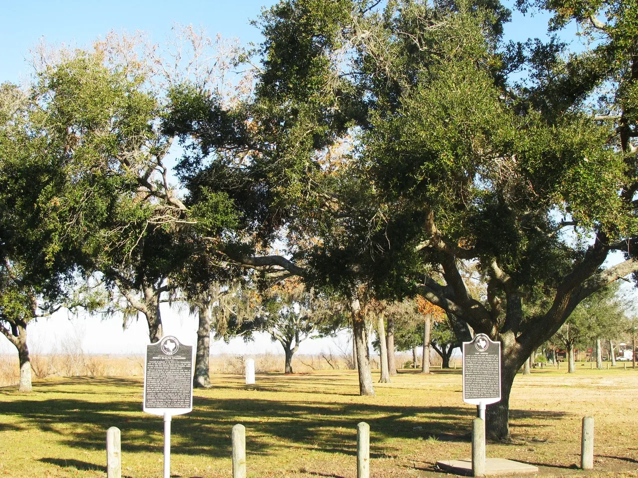
Fort Anahuac Park on the bluff south of town, photographed in January 2010. The two black plaques are Texas historical markers; the park holds several, including the 1936, 1971, 1972, 1973 and 1976 markers cited in this article. No brick of the fort is visible: the Handbook says the county cleared the site and buried the rubble after acquiring it in 1946, and that erosion had already carried the bay-side redoubt into the water. Frank Bodden, CC BY 2.0, via Wikimedia Commons. [39] [3]
1835: a boat full of bricks
With the soldiers gone, merchants came back and trade went on without national tariffs until 1835, when Mexico sent collectors and troops back to Texas. Capt. Antonio Tenorio arrived in January 1835 with about forty men and found the fort in such disrepair that he asked for lumber; when it came in May, angry Texans burned it. Andrew Briscoe, a local merchant, objected that duties were not collected evenly from port to port and refused to cooperate. He loaded a boat so as to excite suspicion, with bricks in the hull instead of smuggled goods. Tenorio arrested him and DeWitt Clinton Harris on June 12. [2] [3]
Travis raised volunteers, took a vessel at Harrisburg and sailed for Anahuac. Here the Handbook disagrees with itself. The disturbances entry says Tenorio surrendered on June 20 to twenty-five insurgents. The fort entry says Travis attacked on June 29, that Tenorio, with no artillery, saw his troops flee into the woods, and that he capitulated the next day. Either way the small garrison was carried to Harrisburg and the fort was never used again. Travis had acted without real community support, the Handbook says, and he felt obliged to apologize publicly so as not to endanger Stephen F. Austin, then in Mexico City. Charles Willcox, the storekeeper, seems to have been allied with both Travis and Tenorio, served as the local subalcalde, and survived an apparent attempt on his life soon afterward. [2] [3] [6]
The town’s oldest graveyard dates to these years. A 2009 marker says the Old Mexican Cemetery, on Willcox’s land at the north end of town, was established in the early 1830s, and that its earliest known burial is Benjamin Freeman, a land-office agent and merchant who died in 1835. Other graves there are unmarked. [31]
1838–1865: Chambersea, a lawsuit and a shotgun
Thomas Jefferson Chambers, a Virginia-born lawyer who had become surveyor general of Texas under Mexico, bought a five-league tract around Turtle Bay and down to Double Bayou on June 23, 1830. It had been titled three months earlier to Vincent Padilla, a kinsman of the land commissioner, under a law that let native Mexicans buy Texas land. Henson’s entry calls the purchase shady though not illegal, and says it made Chambers very unpopular with settlers, some of whom had been on that land since 1824. During the 1832 trouble Chambers sided with the government and was hanged in effigy at Brazoria. [5] [33]
In 1839 he retired to his house at Round Point below Anahuac and renamed the town for himself. The spelling depends on the source: Chambersea in the town, county and Willcox entries and on the 1936 county marker, Chambersia in Chambers’s own entry and the courthouse nomination. The 1936 marker at his home says Chambersea, “later Anahuac,” and the county were named for him. The town, the Handbook says, did not follow suit. In 1838 he and Charles Willcox began a court fight over who owned the townsite. It reached the post office: Willcox’s men called it Anahuac when they held it, Chambers’s associates called it Chambersea when they did, and the county entry dates the first post office, as Chambersea, to 1844. The Texas Supreme Court decided for Willcox in 1862. [1] [5] [6] [27] [26] [33] [4]
There was blood in the land fight. Returning from the United States in May 1842, Chambers found that his whole tract had been sold for back taxes to John O’Brian, who was living at Round Point. When the local court ruled against him, Chambers ambushed and killed O’Brian. The Liberty court did not indict him. O’Brian’s widow carried the case to the state Supreme Court and won in 1855. [5] [33]
Chambers County was formed in 1858 from Liberty and Jefferson counties, with Chambers’s nephew William Morton Chambers as county judge and Wallisville, chosen over Anahuac, as the county seat. By 1860 the general’s property was valued at more than half a million dollars, the most in the county. That year’s census counted 344 enslaved people countywide; of sixty slaveholding families in 1859, John White held thirty-three. Chambers and his nephew represented the county at the Secession Convention, and county voters chose secession 109 to 26. Chambers let the Confederates place a battery on his Anahuac property to guard the mouth of the Trinity, and a company arrived in late 1862 to man the guns at what the sources call Fort Chambers or Fort Chambersia. No major fighting took place in the county. [4] [5] [1] [10]
On the night of March 15, 1865, the Chambers family was gathered in an upstairs parlor when someone fired a shotgun through the open window and killed the general. Nobody was arrested. Local people believed Albert V. Willcox did it. That is the Handbook’s date. The 1968 marker on the house says Chambers was assassinated there in 1863. His widow moved his body to Galveston the next year and sold the house, wharf and warehouse to Charles Willcox. In 1925 the legislature paid Chambers’s descendants $20,000 for his old claim to the land under the Capitol in Austin. [5] [25] [33]
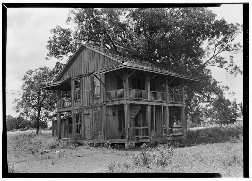
The General Thomas Jefferson Chambers House, Chambersea, front and north side, photographed for the Historic American Buildings Survey by Harry L. Starnes on August 20, 1936. The 1968 marker describes the spiral exterior stair at the front and a “Star” window in the west gable. The sources do not agree on when the house was built: 1840 in the HABS record, 1845 on the marker. The Handbook’s county entry says Chambers’s home was built in 1835 and now holds the county library. Historic American Buildings Survey (HABS TX-281), Library of Congress. Public domain. [35] [25] [4]
1865–1907: freedom, fire and a town that waited
By 1870 the county’s population had fallen to 1,503, below the prewar total. About a third of the residents were Black, and as many as fifteen African Americans owned property. The Freedmen’s Bureau opened a school for Black children at Wallisville in 1869. The Handbook also records Ku Klux Klan opposition to the Union League, which worked to enroll Black voters, and other opposition to improvements in the lives of former slaves. It does not give names or incidents for Chambers County, and this article does not add any. [4] [29]
The freedpeople built their own institutions. A 1982 marker at Double Bayou, seven miles southeast of Anahuac, says St. Paul United Methodist Church was founded in 1869 by a group of former slaves. Charter member Martha Godfrey, born about 1812 in Tennessee and brought to Texas enslaved by the Mayes family, deeded the church its land in the 1870s and gave the first tract of the cemetery that bears her name. The Double Bayou school met in the church from the early 1880s until 1920, and funerals there have traditionally included, the marker says, the muffled ringing of a small bell called the toner. [30]
Anahuac itself barely grew. On December 2, 1875, fire destroyed the courthouse at Wallisville with all its records. Liberty County’s courthouse had burned a year earlier, and the National Register nomination says many suspected land speculators of setting both fires to confuse land titles. The Handbook’s Wallisville entry says flatly that arsonists destroyed it. Hurricanes in 1875 and 1900 hurt crops and stock, and smallpox in 1877 killed many residents. Through the 1880s and 1890s, the county entry says, the lumber trade built up Wallisville “while Anahuac remained unoccupied.” Charles Willcox died at Anahuac on February 7, 1876. [33] [4] [10] [6]
A few people did settle there. Dr. Nicholas T. Schilling, a Bavarian-born Civil War veteran of the Maryland cavalry, came to Cedar Bayou in 1874, married in 1883 and built a medical office in 1890; he fitted eyeglasses, did dentistry and took fees in vegetables, livestock and farm labor. After his daughter Annie died in 1966, the office was donated to the county and brought to Anahuac by barge; it stands at Washington Avenue and Cummings Street, by Chambersea. Ross Shaw Sterling, governor of Texas from 1931 to 1933 and a founder of Humble Oil, was born in 1875 and raised on a family farm about four miles south of town, according to his 1970 marker. [32] [41]
The first real industry came in 1894, when Jesse and Charles R. Cummings opened a large sawmill at Anahuac. The town entry says the mill moved to Wallisville in 1898. The Wallisville entry says the brothers consolidated their Liberty and Anahuac mills at Wallisville in 1899. The county entry says their Cummings Export Lumber Company was built in 1898 and closed after the 1915 hurricane. [1] [10] [4]
1902–1937: rice, a county seat and two courthouses
Water made the town. In 1902 Berriman Richard Garland and A. L. Williams started the Lone Star Canal, which drew fresh water from Turtle Bay to rice fields in northern Chambers County; it was incorporated in 1904 and watered 10,000 acres. Sailing vessels loaded the rice at the company warehouse. Salt water creeping into the bay in dry seasons killed crops, which led to a dam at the mouth of the bay. Meanwhile the Anahuac Townsite Company, led by William Duncan Willcox, George R. Fahring and Francis M. Hamilton, began selling lots, and the Handbook says Anahuac “had become a boomtown.” [11] [28] [12] [1] [4]
On April 11, 1907, voters made Anahuac the county seat instead of Wallisville. Wallisville fought the result, but the First Court of Civil Appeals ordered the records moved to Anahuac in 1908. The county met for a time in Woodman Hall over Willcox & Swinney’s store. A towered Renaissance Revival courthouse was finished on August 21, 1912, with indoor plumbing, telephones, electric lights and, the nomination records, a separate outdoor toilet for “colored people.” A 2005 marker says Black families in the new county seat sent their children to classes at St. James Methodist Church, organized in 1908, the same year Anahuac took the courthouse. [1] [33] [29]
The 1915 hurricane destroyed the canal company’s warehouse at Anahuac, its pumping station and the bay dam. After it, county residents seriously considered dissolving Chambers County and dividing it among Harris, Jefferson and Liberty counties. Attempts came in 1915, 1923 and 1925, driven by fights over stock laws, prohibition and the county seat, and by tax offers from neighboring counties that wanted the oil fields; the nomination says a 1931 petition drive finally ended it. The Anahuac Independent School District was organized in 1917. The Anahuac and Turtle Bay oil fields came in in 1935. The Almanac’s chart puts the town at 500 people in 1920, 800 in 1930 and 1,500 in 1940. [11] [28] [33] [4] [1]
On April 28, 1935, the 1912 courthouse burned; the sheriff blamed an electrical short. The county judge saved the records by throwing them out of second-story windows. Two months later, on June 29, 1935, voters were asked once more whether to keep the seat at Anahuac, and the returns heavily favored keeping it. A $90,000 Public Works Administration grant came in December 1935. Austin architect Corneil G. Curtis designed a three-story concrete building faced in Texas fossil limestone, El Paso builder Robert E. McKee built it, and it was accepted on June 14, 1937, at a cost of $276,000. It was dedicated June 26, 1937, with a parade, a barbecue, three ball games and a dance. It is the building in the photograph at the top of this page, and the nomination says it served the county without interruption from then on. [33] [38]
1943 to now: a city, a lake and the Gatorfest
After September 1943, rice farmers in the county used German prisoners of war from camps in Liberty and Chambers counties. Anahuac voters approved incorporating the city on October 30, 1948, and elected attorney Everett Cain mayor on January 8, 1949. Interstate 10 was built through the county in 1955. A new dam, levee and spillway at the mouth of Turtle Bay, begun March 17, 1953, and finished in July 1954, roughly doubled the storage of what was by then called Lake Anahuac. [4] [1] [12]
Chambers County bought the fort site for a park in 1946. Officials had it cleared and the rubble buried, for safety and to prevent vandalism, and an amateur excavation in 1968 came before preservation laws took effect. The Handbook says no in-depth archeological study of the site has been made. Two Anahuac buildings are on the National Register of Historic Places: Chambersea, listed November 19, 1979, and the 1937 courthouse, listed April 25, 2008. [3] [34] [33]
Segregated schooling ended in these years. The 2005 marker names George Washington Carver and Double Bayou as the county’s two high schools for Black students and says all of its schools had been desegregated by 1966. In the same period, the county entry says, many Black residents left for jobs in the cities. The U.S. Fish and Wildlife Service established the Anahuac National Wildlife Refuge sixteen miles southeast of town in 1963, at first on 12,000 acres, a winter home for ducks and geese and a home for alligators. The Anahuac Area Chamber of Commerce held the first Gatorfest at Fort Anahuac Park in September 1989, and 14,000 people came. [29] [4] [16] [1]
The population figures do not line up neatly, and we print them as published. The Almanac chart on the Handbook page gives 1,282 for 1950, 2,105 for 1960, 1,881 for 1970, 1,840 for 1980, 1,993 for 1990, 2,210 for 2000 and 2,243 for 2010. It then shows 2,508 for 2019 and 1,980 for 2020, and 1,962 for 2021. The chart does not explain the 528-person gap between 2019 and 2020, and we do not try to. The Census Bureau’s current estimates start from an April 2020 base of 1,973 and put the city at 2,023 on July 1, 2025. [1] [37] [36]
The complete story of Anahuac
It is the story of an Atakapan village on a bay, a filibuster’s camp, and a Mexican customs post built of bricks the soldiers made themselves. It is the story of enslaved men who ran to a Mexican fort for freedom, and of the lawyer hired to get them back, who became a hero of Texas. It is the story of two uprisings that the markers call the first sparks of the Revolution and that the Handbook calls part of Mexico’s own civil war. It is also the story of a land speculator who killed a man over a town and was killed in his parlor, of freedpeople who built a church at Double Bayou in 1869, of a canal, a county-seat election, two courthouse fires and a county that refused to dissolve. The fort is gone. The bluff is still there. [2] [3] [5] [9] [30] [33]
Questions people ask
What does the name Anahuac mean? It was borrowed from Anáhuac, which the Handbook calls the name of the ancient home of the Aztecs; the 1936 marker calls it the Aztec name of Mexico City. The Handbook credits Gen. Manuel de Mier y Terán with officially naming the town in January 1831; two state markers and the county entry give earlier dates. [1] [3] [18] [19]
What happened at Anahuac in 1832? Mexican commander Juan Davis Bradburn arrested William B. Travis, Patrick C. Jack and others. Armed colonists came to free them; there was fighting June 10–12, 1832; the rebels wrote the Turtle Bayou Resolutions; and Bradburn was removed in July. The Handbook treats it, with a second confrontation in June 1835, as one of the events that led to the Texas Revolution. [2] [3] [9]
Is anything left of Fort Anahuac? Not above ground. The garrison dismantled it in 1832, residents took its bricks, erosion took the bay-side redoubt, and the county buried the remaining rubble after buying the site in 1946. The site is now Fort Anahuac Park, a mile south of town, with several state markers. [3]
When did Anahuac become the county seat? Voters chose Anahuac over Wallisville on April 11, 1907, and the courts ordered the records moved in 1908. Wallisville had been the seat since the county was formed in 1858. [1] [33] [10]
What is Anahuac’s ZIP code? 77514. Anahuac is on State Highway 61 on the northeast shore of Trinity Bay, south of Interstate 10, in Chambers County. [1] [24]
Sources
Kevin Ladd, “Anahuac, TX,” Handbook of Texas Online, Texas State Historical Association, revised September 20, 2023. Its bibliography includes Jewel Horace Harry, A History of Chambers County (M.A. thesis, University of Texas, 1940), Margaret S. Henson, Anahuac in 1832: The Cradle of the Texas Revolution (1982), and Henson and Kevin Ladd, Chambers County: A Pictorial History (1988). The page also carries the Texas Almanac’s population chart, 1920–2021. tshaonline.org/handbook/entries/anahuac-tx.
Margaret S. Henson, “Anahuac Disturbances,” Handbook of Texas Online, revised September 8, 2020. tshaonline.org/handbook/entries/anahuac-disturbances.
Margaret S. Henson, “Fort Anahuac,” Handbook of Texas Online, revised January 1, 1995. tshaonline.org/handbook/entries/fort-anahuac.
Diana J. Kleiner, “Chambers County,” Handbook of Texas Online, revised October 8, 2020. tshaonline.org/handbook/entries/chambers-county.
Margaret S. Henson, “Chambers, Thomas Jefferson (1802–1865),” Handbook of Texas Online, revised July 28, 2020. tshaonline.org/handbook/entries/chambers-thomas-jefferson-1802-1865.
Kevin Ladd, “Willcox, Charles,” Handbook of Texas Online, revised March 19, 2019. tshaonline.org/handbook/entries/willcox-charles.
Margaret S. Henson, revised by James Aalan Bernsen, “Bradburn, John (Juan) Davis,” Handbook of Texas Online, revised December 12, 2023. Henson is also the author of Juan Davis Bradburn: A Reappraisal of the Mexican Commander of Anahuac (Texas A&M University Press, 1982). tshaonline.org/handbook/entries/bradburn-john-juan-davis.
Margaret S. Henson, revised by James Aalan Bernsen, “Perry, Henry,” Handbook of Texas Online, revised October 22, 2025. tshaonline.org/handbook/entries/perry-henry.
Margaret S. Henson, “Turtle Bayou Resolutions,” Handbook of Texas Online, revised June 13, 2020. tshaonline.org/handbook/entries/turtle-bayou-resolutions.
Kevin Ladd, “Wallisville, TX,” Handbook of Texas Online, revised August 1, 1995. tshaonline.org/handbook/entries/wallisville-tx.
Robert Wooster, “Lone Star Canal Company,” Handbook of Texas Online. tshaonline.org/handbook/entries/lone-star-canal-company.
“Lake Anahuac,” Handbook of Texas Online (no author listed). tshaonline.org/handbook/entries/lake-anahuac.
John G. Johnson, “La Harpe, Jean Baptiste Bénard de,” Handbook of Texas Online, revised August 3, 2020. tshaonline.org/handbook/entries/la-harpe-jean-baptiste-benard-de.
Harris Gaylord Warren and Betje Black Klier, “Lallemand, Charles François Antoine,” Handbook of Texas Online, revised August 7, 2020. tshaonline.org/handbook/entries/lallemand-charles-francois-antoine.
Kevin Ladd, “El Orcoquisac,” Handbook of Texas Online, revised September 10, 2020. tshaonline.org/handbook/entries/el-orcoquisac.
Diana J. Kleiner, “Anahuac National Wildlife Refuge,” Handbook of Texas Online, revised November 1, 1994. tshaonline.org/handbook/entries/anahuac-national-wildlife-refuge.
Mickie Baldwin, “White, James Taylor,” Handbook of Texas Online, revised April 20, 2017. tshaonline.org/handbook/entries/white-james-taylor.
Texas Historical Commission, “Fort Anahuac,” historical marker (1976), Fort Anahuac Park, Chambers Drive. Texas Historic Sites Atlas, atlas no. 5071009123. atlas.thc.texas.gov/Details/5071009123.
State of Texas, “On this Site First Known as Perry’s Point,” historical marker (1936), Fort Anahuac Park. Texas Historic Sites Atlas, atlas no. 5071009124. atlas.thc.texas.gov/Details/5071009124.
Texas Historical Commission, “Events at Anahuac Leading to the Texas Revolution,” historical marker (1965), SH 61 near Magnolia Street. Texas Historic Sites Atlas, atlas no. 5071009121. atlas.thc.texas.gov/Details/5071009121.
Texas Historical Commission, “Juan Davis Bradburn,” historical marker (1973), Fort Anahuac Park. Texas Historic Sites Atlas, atlas no. 5071009113. atlas.thc.texas.gov/Details/5071009113.
Texas Historical Commission, “William Barret Travis,” historical marker (1971), Fort Anahuac Park; erected by the Chambers County Historical Survey Committee. Texas Historic Sites Atlas, atlas no. 5071009135. atlas.thc.texas.gov/Details/5071009135.
Texas Historical Commission, “Robert McAlpin Williamson,” historical marker (1972), Fort Anahuac Park. Texas Historic Sites Atlas, atlas no. 5071009140. atlas.thc.texas.gov/Details/5071009140.
Texas Historical Commission, “Near Site of the Signing of Turtle Bayou Resolutions,” historical marker (1968), Whites Park, SH 61 just south of I-10. Texas Historic Sites Atlas, atlas no. 5071009136. atlas.thc.texas.gov/Details/5071009136.
Texas Historical Commission, “Chambersea,” Recorded Texas Historic Landmark marker (1968), Washington Avenue at Cummings Street. Texas Historic Sites Atlas, atlas no. 5071009117. atlas.thc.texas.gov/Details/5071009117.
State of Texas, “Home of Thomas Jefferson Chambers,” historical marker (1936), Washington Avenue at Cummings Street. Texas Historic Sites Atlas, atlas no. 5071009116. atlas.thc.texas.gov/Details/5071009116.
State of Texas, “Chambers County,” historical marker (1936), SH 61 near Kansas Avenue. Texas Historic Sites Atlas, atlas no. 5071009118. atlas.thc.texas.gov/Details/5071009118.
Texas Historical Commission, “Lone Star Canal,” historical marker (1979), SH 61 at Washington Avenue. Texas Historic Sites Atlas, atlas no. 5071009126. atlas.thc.texas.gov/Details/5071009126.
Texas Historical Commission, “Black Education in Chambers County,” historical marker (2005; text dated 2006), 1222 Main Street. Texas Historic Sites Atlas, atlas no. 5507013808. atlas.thc.texas.gov/Details/5507013808.
Texas Historical Commission, “St. Paul United Methodist Church,” historical marker (1982), Double Bayou community, seven miles southeast of Anahuac. Texas Historic Sites Atlas, atlas no. 5071009132. atlas.thc.texas.gov/Details/5071009132.
Texas Historical Commission, “Anahuac’s First Cemetery,” historical marker (2009), north end of N. Bay Avenue. Texas Historic Sites Atlas, atlas no. 5507016043. atlas.thc.texas.gov/Details/5507016043.
Texas Historical Commission, “The Dr. N. T. Schilling Medical Office,” historical marker (1976), Washington Avenue at Cummings Street. Texas Historic Sites Atlas, atlas no. 5071009133. atlas.thc.texas.gov/Details/5071009133.
National Register of Historic Places nomination, “Chambers County Courthouse,” Anahuac, listed April 25, 2008 (reference no. 08000339), Section 8, statement of significance and history of the county’s courthouses (adapted in part from the Handbook’s county entry and the 2006 Chambers County Courthouse Historic Preservation Master Plan by Bailey Architects). Texas Historical Commission Atlas. atlas.thc.texas.gov/NR/pdfs/08000339/08000339.pdf.
Texas Historical Commission, National Register listing “Chambersea,” Washington and Cummings streets, listed November 19, 1979 (reference no. 79002925). Texas Historic Sites Atlas. atlas.thc.texas.gov/Details/2079002925.
Historic American Buildings Survey, “General Thomas Jefferson Chambers House, Cummings Street, Anahuac, Chambers County, TX,” HABS TX-281, five photographs by Harry L. Starnes, August 20, 1936, three measured drawings and three data pages. Library of Congress Prints and Photographs Division. loc.gov/item/tx0181.
U.S. Census Bureau, Population Estimates Program, “City and Town Population Totals: 2020–2025” (sub-est2025), row for Anahuac city, Texas: April 1, 2020 estimates base 1,973; July 1, 2025 estimate 2,023. www2.census.gov … sub-est2025.csv.
Texas Almanac, “Anahuac,” Texas State Historical Association (population count 1,962 for 2021). texasalmanac.com/places/anahuac.
Larry D. Moore, “Chambers county tx courthouse 2014.jpg,” photographed April 19, 2014, CC BY 4.0, Wikimedia Commons. commons.wikimedia.org/wiki/File:Chambers_county_tx_courthouse_2014.jpg.
Frank Bodden, “Fort Anahuac,” photographed January 18, 2010, CC BY 2.0, via Flickr and Wikimedia Commons. commons.wikimedia.org/wiki/File:Fort_Anahuac.jpg.
Texas Historical Commission, “James Taylor White,” historical marker (1980), Chambers County Safety Rest Area, I-10 eastbound. Texas Historic Sites Atlas, atlas no. 5071012650. atlas.thc.texas.gov/Details/5071012650.
Texas Historical Commission, “Birthplace of Governor Ross Shaw Sterling,” historical marker (1970), FM 563 about four miles south of Anahuac. Texas Historic Sites Atlas, atlas no. 5071009134. atlas.thc.texas.gov/Details/5071009134.