The History of Calvert, Texas
Calvert, Texas (ZIP 77837) was platted in 1868 for the Houston and Texas Central and named for a planter who died of yellow fever the year before. It held the county seat for most of the 1870s and claimed the world’s largest cotton gin; the Handbook dates that claim to 1871, a federal building survey to 1912.
Editor’s note. This is the twenty-ninth installment of “Texas Towns: The Stories Behind the Map.” The last one went to Roma, on the Rio Grande, a river town the railroad never reached. This one comes back north to the Brazos prairie, to a town that exists only because a railroad came. Readers of our Anderson installment will remember that landowners there refused the Houston and Texas Central a right-of-way in 1857. Up the Brazos valley, the planters of Robertson County did the opposite. They asked for the tracks, and the tracks built Calvert.
Calvert, Texas, sits where State Highway 6 meets Farm roads 1644 and 979, on the old Southern Pacific line nine miles north of Hearne in west central Robertson County. The railroad, now part of the Union Pacific, still runs beside the highway, and the highway is still Main Street. Calvert is not the county seat; that is Franklin. But it was, for most of the 1870s. The mailing ZIP is 77837. [1] [2]
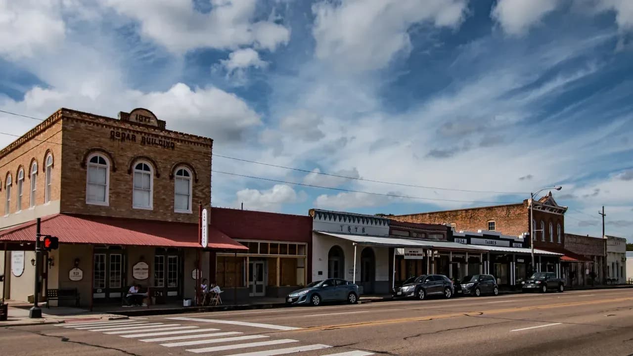
Drive through today and the first thing you notice is how much of the nineteenth century is still standing: a long row of brick commercial buildings facing the tracks, date stones of 1877 and 1878 on the fronts, a courthouse that never held court, and a church building older than the town itself. The town is small now. The Census Bureau puts it under a thousand people. The National Register of Historic Places has listed the Calvert Historic District since April 3, 1978. The story behind those buildings is a story of cotton and railroads, but it is also a story of slavery and what came after it, of an epidemic, of Chinese laborers brought in to do railroad work, and of a county-seat fight decided in the legislature. This article tells it the way the record does. [1] [32] [29] [30]
Before 1868: Sterling, a plantation and the old county seats
The land around Calvert sits between the Brazos River bottom to the west and the upland prairie and post-oak country to the east. The Handbook of Texas describes the Brazos Bottom in Robertson County as about 150,000 acres of fertile delta land between the Brazos and the Little Brazos rivers, and it was that soil that drew planters. The earliest White settler the Handbook names in the immediate area was Joseph Harlan, whose 1837 land grant lay five miles south of the future townsite. [2] [1]
The frontier was violent in those first years. A 1972 state marker near Calvert says that on a Sunday night in November 1836 an Indian raiding party attacked the family of John Harvey a mile west of the marker, killing Harvey, his wife and their son, and carried off their five-year-old daughter, Ann, and a servant girl. The marker says Ann was recovered from Mexico by an uncle four years later and, as an adult, settled with her husband near the site. The marker does not name the raiders’ nation. The Handbook says the raids began to abate after 1838, when a company of Texas Rangers under Eli Chandler was stationed at Old Franklin, the first county seat. [35] [2]
Robert Calvert, the man the town is named for, arrived in 1850. The Handbook says he was born February 19, 1802, near what became Wartrace, Tennessee, married Mary Keesee in Tuscaloosa, Alabama, in 1823, and served as a county judge in Saline County, Arkansas, before coming to Texas. In Robertson County he cleared a large plantation in the Brazos valley, grew corn and cotton and made a substantial fortune. He served in the Fifth Texas Legislature from 1853 to 1855 for a district made up of Milam and Robertson counties, and the Handbook says he aided the Confederate war effort by provisioning the army. The state’s 1968 marker calls him “a descendant of Lord Baltimore of Maryland”; the Handbook entry on his life does not mention that. [3] [12]
The fortune was made with enslaved labor, and the county record is blunt about it. The Handbook says that during the 1850s the enslaved population of Robertson County grew from 264 to 2,258, that by 1860 forty percent of the county’s families owned one or more slaves, and that two of the largest slaveholders in Texas lived in the county. During the Civil War planters from Arkansas and Louisiana moved their enslaved people into the county to keep them from Union lines, and the number more than doubled, from 1,955 to 4,392. Nearly 85 percent of the county’s voters, 391 of 467, voted for secession. The Handbook does not give a count for Calvert’s own plantation, and this article will not guess one. [2] [3]
There was a community nearby before there was a Calvert. The state’s “Town of Calvert” marker says it began as Sterling, in Sterling C. Robertson’s colony of the 1820s, and served as a mustering and military supply point during the Civil War. The county seat in those years was Owensville, near the center of the county, where the court moved its records in August 1856 after stops at Old Franklin and Wheelock. [12] [4] [2]
1867–1869: the railroad and a town named for a man who did not see it
The Houston and Texas Central had built eighty-one miles north from Houston to Millican by April 1861, and the Civil War stopped it there. Construction resumed in 1867. The Handbook says Robert Calvert and other area farmers urged the company to build through Robertson County, and that he used his influence to bring it. [7] [1] [3]
Calvert did not live to see the town. He died on September 20, 1867, during that year’s yellow fever epidemic, and was buried in Sterling Cemetery. The Handbook’s yellow fever entry calls 1867 the deadliest yellow fever season in Texas history. [3] [11]
In January 1868 a group of investors bought land at the townsite and platted it. By February merchants from Sterling and Owensville were moving to the new town, and a post office opened that year. The state marker puts it more simply: when the railroad route was set in 1868, the town was “moved 2 mi. to the right of way” and renamed for Judge Calvert. The two accounts describe the same pull of the tracks in different words; the Handbook speaks of merchants moving from two older places, and the marker of one town relocating. Readers who know our Willis installment will recognize the pattern. [1] [12]
The sources also give different dates for the railroad’s arrival. The town entry says the railroad “arrived in 1868” and the first trains reached Calvert in 1869. The Robert Calvert entry says the town was named for him when the railway was completed there in 1868. The Hearne entry says the line reached the Hearne depot, nine miles south, in April 1868. Another marker says a depot at Hammond, on the same line, opened after a planter granted right-of-way through his land in 1869. We print all of them. [1] [3] [6] [24]
The railroad gave the town its ground as well as its trade. The state’s markers say the Houston and Texas Central donated lots for the Baptist church in 1868 and gave Calvert the land for a park, now Virginia Field Park, the same year. Some of the first buildings went up immediately. The marker for the Citizens Bank & Trust Co. Building says James S. Hanna built it in 1868 as a general store. Cobb’s Market began as a meat market in 1868. [15] [20] [21] [34]
1870: county seat by act of the legislature
Calvert incorporated with an aldermanic government in 1870, and that same year it took the county seat from Owensville. How it happened is a Reconstruction story. The Owensville entry says that when the Reconstruction government appointed I. B. Ellison county judge in 1868, a man “not well received,” he moved the county records to Calvert. The county entry says that on July 12, 1870, the Republican-controlled Twelfth Legislature voted to relocate the county seat to Calvert “in a political move to retain Republican political control of local government.” The Owensville entry gives the date of the act as July 13, 1870. When the courthouse left, Owensville quickly died; by 1990 its site was marked only by a graveyard. [1] [2] [4]
The Republican strength the legislature was protecting belonged largely to Black voters. The Handbook says the party in Robertson County drew much of its strength from Black voters on the plantations around Calvert, and that for a number of years it elected Black men from Calvert to county and state office. One of them was Giles Cotton. The Handbook says he was born enslaved around 1814 in South Carolina, came to the Robertson colony near present Calvert in 1837, was moved to Limestone County after his enslaver’s death, and returned to the Calvert area as a farmer after emancipation. In late 1869 voters of Robertson, Leon and Freestone counties elected him to the Texas House. He served from February 10, 1870, to January 14, 1873, and supported the legislation that made Calvert the county seat. The 1870 census recorded that Cotton and his wife, Rachel, could not read or write; they formalized their marriage on September 5, 1870. He died near Hammond in 1883 or 1884. [1] [8]
Calvert was also briefly occupied by federal troops early in 1870, the Handbook says, and the town’s first school was founded that year. The 1968 marker at Virginia Field Park adds that during Reconstruction, from 1868 to 1873, a “Sky Parlor,” a room built on a pole like a tree house, stood there as a prison for Southern sympathizers. That detail comes from the marker alone; the Handbook does not mention it. [1] [20]
The Chinese came to Calvert with the railroad that same season. The Handbook’s entry on Chinese Texans says the first group in the state, 250 contract laborers from California, arrived in January 1870 with the Houston and Texas Central, “whose railhead was then at Calvert.” Their work on the line ended abruptly in less than a year, and most left Texas, but some stayed. In 1880 the seventy-two Chinese in Robertson County were 53 percent of all the Chinese in Texas, and in the 1870s most were sharecroppers and field hands on plantations near Calvert and Hearne. The state’s 1968 marker on Main Street dates their arrival to “about 1874,” says at least twenty-four families were brought to work cotton, and says many stayed as permanent residents. The two dates do not match, and we print both. [10] [19]
1871–1879: the largest gin in the world, yellow fever and a courthouse left empty
As a rail center and county seat, Calvert boomed. The Handbook says that in 1871 the town claimed to have the largest cotton gin in the world. The Historic American Buildings Survey, in its study of Main Street, gives a different year for the same boast: it says that at one time, in 1912, Calvert could claim the world’s largest gin, and its study of the Gibson Gin office says the Gibson Gin and Oil Company, incorporated in 1899, claimed by 1912 to be the world’s largest ginning operation. It is possible both claims were made, decades apart. The sources do not say, and this article does not decide. [1] [26] [28]
The same survey says most of the buildings along Main Street went up in the prosperous years from 1870 to 1900. The state markers fill in a few of them. A foundry, founded about 1870 as one of Calvert’s first industries, made farm tools from iron ore hauled in by horse-drawn wagon. Jean Pierre Casimir, a native of Toulouse, France, built a drugstore sometime after 1869 that his family ran until 1949, connected by a rear patio to the Palace Opera House, which the family also owned. Mrs. Ella Oscar rebuilt the 1868 meat market in handmade brick in 1878. The bank building on Main belonged in 1870 and 1871 to the Rev. Robert Crawford, whom its marker calls a San Jacinto veteran; the Handbook’s county entry names a Robert Crawford, San Jacinto veteran, as a Methodist circuit minister in the county in 1840, and does not say whether they were the same man. [26] [23] [22] [34] [21] [2]
In 1873 yellow fever came back. The Handbook says a severe epidemic killed many in the community. The marker at the old courthouse says Calvert “lost many leaders” to it. Neither source gives a death toll, and we have not found one in the sources used here. [1] [13]
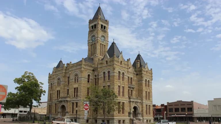
Two years later, in 1875, the county began the courthouse. The Historic American Buildings Survey says St. Louis architect W. P. Ingraham designed it as the Robertson County Courthouse in 1875 and that it was completed in July 1879. By then the county seat was already on its way out. The Franklin entry says the railroad town of Morgan, on the International line near the center of the county, had 200 residents by 1879, when voters moved the seat there; because Texas already had a Morgan post office, the town took the name Franklin, after the old county seat. The county entry dates that vote to 1878; the town and Franklin entries and the courthouse marker say 1879; the building survey says the seat moved in December 1879. The new courthouse never served as one. [27] [5] [2] [1] [13]
The survey says the county sheriff and his family lived in the building, known then as Ingraham Castle, until the spring of 1881. Robert A. Brown, a merchant, investor and planter, bought it in 1885 and, with his wife, Lucy Herndon Brown, made it a residence. His heirs sold it in 1909 to Mrs. Fannie L. Hammond, and it is known today as the Hammond House. The marker says the Hammond family held it until 1966, when it became a museum; the survey says the family’s heirs sold it to the Robertson County Historical Commission in 1967. [27] [13]
Faith in Calvert: churches that moved with the town
Calvert’s congregations are some of the oldest things in it, and some are older than the town. The state marker for the First Presbyterian Church says the building was put up at Sterling before the Civil War, on Robert Calvert’s land, with imported leaded glass and materials and labor from his plantation. Calvert’s heirs gave it to the congregation, then Cumberland Presbyterian; it was moved to Calvert in 1868, remodeled in 1877 and placed on its present site at Beech and Barton in 1913. The Handbook tells it slightly differently: it says Calvert himself donated the land for the original church and was an elder in the Presbyterian church. The church was built on a plantation before emancipation; the marker says only that the materials and labor “were from Calvert’s plantation,” and does not name the workers. [14] [3]
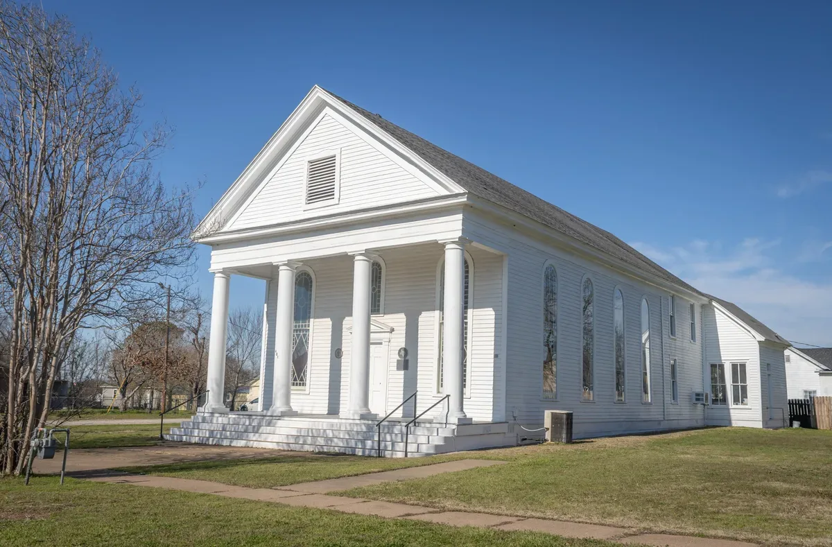
First Presbyterian Church in Calvert, photographed January 12, 2024. The state marker says the building was put up at Sterling before the Civil War, moved to Calvert in 1868, remodeled in 1877 and set on this lot in 1913, so the porch and columns seen here may not match how it looked on its first site. Rene Gomez (Renegomezphotography), CC BY-SA 4.0, via Wikimedia Commons. [33]
The Baptists, says their marker, had been worshiping in the area as early as 1835. The railroad gave them lots in 1868, and they met in a private home until they built a brick church at Hanna and Pine in 1873. That church hosted the Baptist State Convention in 1875 and sent two women from Calvert, Alyne Guynes Muirhead in 1907 and Sammie Guynes Johnson in 1915, as missionaries to Brazil. The Methodists organized in 1869 as the Calvert Methodist Church and built their first sanctuary in 1872; their pastors included Seth Ward, later the first native Texan named a Methodist bishop, and James Kilgore, a founder of Southern Methodist University. The church took its present name, Sneed Memorial, in 1923 in honor of the circuit rider Joseph P. Sneed. [15] [17]
The Episcopal Church of the Epiphany was organized June 6, 1870, by Bishop Gregg, and its marker calls it the oldest church building erected in Calvert. The Handbook’s county entry says the Episcopal church was headed after the war by the Reverend J. Wilkins Tray. The two claims of age can both be true: the Presbyterian building is older, but it was built at Sterling and moved, while the Epiphany building was the first raised in Calvert itself. [16] [2]
Calvert’s Black Methodists built their own church. The state marker for St. Paul United Methodist Church says the congregation organized in 1872 as St. Paul Methodist Episcopal Church, North. After the first building burned, the carpenter and church member Charlie Terrill built the present Gothic Revival sanctuary in 1900, partly from what could be salvaged of the old one, and the church hosted the West Texas Annual Methodist Conference in 1913. The marker describes it as a place of worship and a center of community life, and in a town where the Handbook says Black voters were driven from the polls, that was not a small thing. [18] [2]
1880–1900: three thousand people and the end of the Black vote
Losing the courthouse did not stop Calvert. The Handbook counts some fifty-two businesses in 1878 and an estimated 3,000 inhabitants by 1884, with Presbyterian, Methodist, Baptist, Episcopal and Catholic churches, public schools, two banks, an opera house and a weekly paper, the Courier. The Sanborn fire-insurance surveyors who mapped Calvert in July 1885 also wrote “Population 3000” on their map, along with a verdict that the town’s water facilities were “not good.” The Texas Almanac table on the Handbook’s page gives a lower census count: 2,280 in 1880 and 2,632 in 1890. [1] [31]
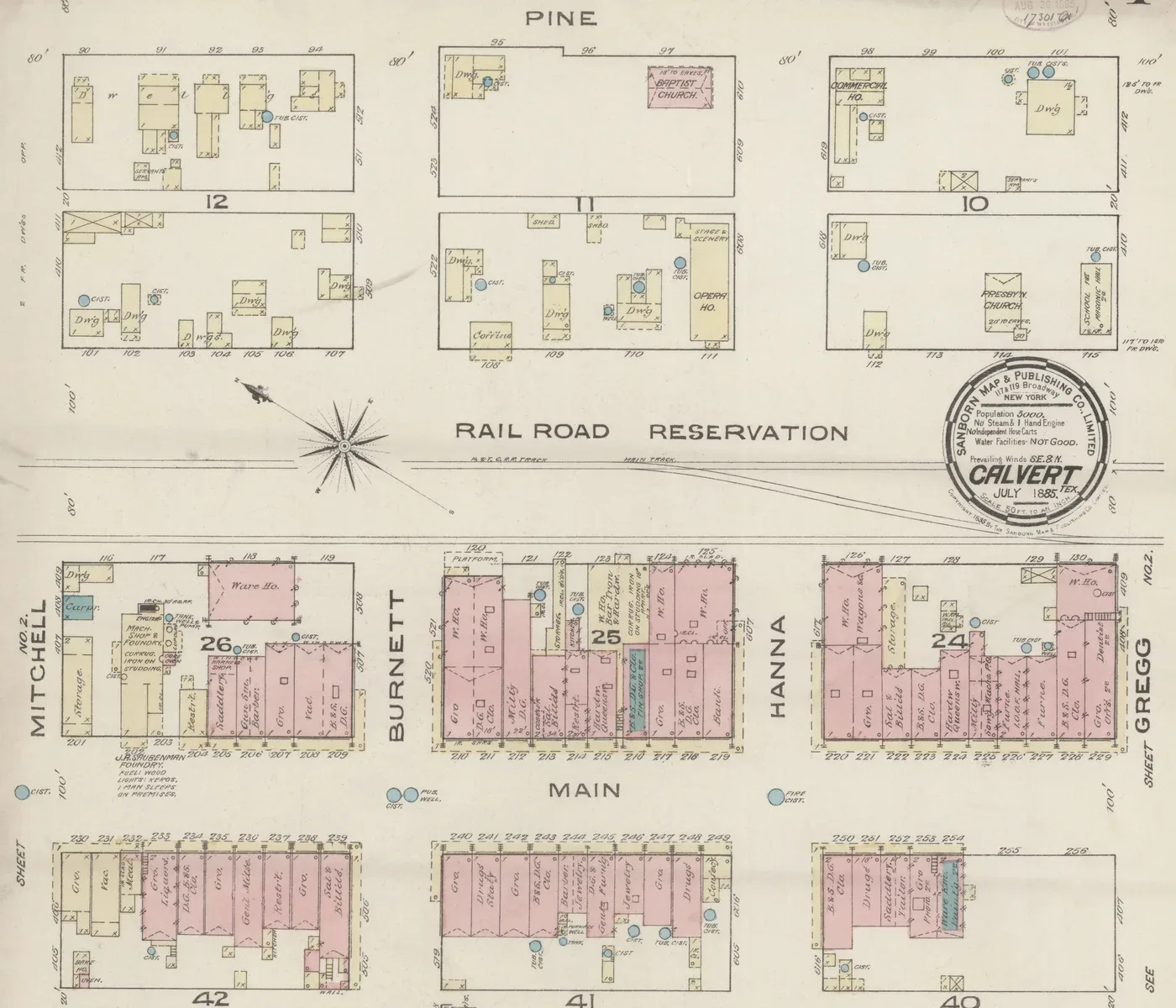
Downtown Calvert on the first sheet of the Sanborn Map & Publishing Co. survey of July 1885, cropped. Pink marks brick buildings and yellow marks frame. The railroad reservation crosses the middle, Main Street is lined with brick stores, and the map labels a Baptist church, a Presbyterian church, an opera house and the Calvert Cotton Co.’s cotton platform. The seal at right gives the population as 3,000. The Presbyterian church shown here is on its 1885 lot; its marker says it was moved to its present site in 1913. Sanborn Map & Publishing Co., Library of Congress Geography and Map Division, public domain, via Wikimedia Commons. [31]
Black political power in the county did not end all at once. The Handbook says Whites regained the upper hand in the early 1870s and through intimidation and occasional force disfranchised most African Americans over the next decade, but that in places like Hearne and Calvert, with substantial Black majorities, Black residents resisted White domination “well into the 1890s.” Harriel G. “Hal” Geiger, a formerly enslaved blacksmith from Hearne, won a legislative seat in 1878 with Greenback endorsement, lost in 1880, won a special election in 1881 and lost again in 1882 after being reportedly convicted of bribery. In the legislature he criticized the convict lease system and opposed the poll tax. The Handbook says he practiced law afterward and was “allegedly killed around 1886 by a White judge for insolent remarks he made in court.” Those are the Handbook’s words and its hedges, and we keep them. [2] [9]
The end came in 1896. The Handbook says that in that year’s election Whites stood guard at polling places across the county with rifles, pistols and sticks and turned away Black voters, and that Black voters did not return to the polls. Intimidation, the poll tax and the White primary finished the job. County voting totals fell from about 5,500 in 1896 to fewer than 1,500 in 1904. Black residents had been a majority of the county since the 1880s; after 1900, the Handbook says, the migration of many to Northern cities ended that majority. [2]
1899–1968: flood, fire and a long, slow decline
Calvert was a major cotton center around 1900, with a number of gins, cotton compresses and cottonseed oil mills, and the census of that year counted 3,322 people, the most the town has ever had. Then came trouble. The Handbook says floods damaged the town in 1899 and that two years later, in 1901, a fire destroyed much of the business district. The building survey dates the bad floods to 1912 and 1921, says they did serious damage to the plantations around the town, and adds the First World War and the shift of population to the cities as reasons for the decline. The two lists do not overlap; both may be right. [1] [26]
The Gibson Gin office and weigh platform that the federal survey documented were built in 1918 by a local carpenter, W. H. Lange; a tornado took the canopy over the weigh platform in 1975. Women in town organized a chapter of the American Woman’s League in 1908, and the league built them a Prairie-style chapter house in 1909 on a lot donated by Ella Hamman. Local women later reorganized as the Calvert Woman’s Club and ran a community library from the building, now named for Katy Hamman Stricker, a charter member who supported it for years. [28] [25]
The population fell, with a brief rise in the 1940s: 2,579 in 1910, 2,099 in the mid-1920s, 2,366 in 1940, 2,561 in 1950 and 2,073 in 1960. In 1968 many former residents came home to help celebrate Calvert’s centennial. That same year the state put up several of the markers quoted in this article. [1] [12] [13]
Since 1978: the district and the numbers
The National Register listed the Calvert Historic District on April 3, 1978, roughly bounded by Main, Garritt, Pin Oak, Maple and Barton streets. The Historic American Buildings Survey later documented the 400 to 700 blocks of Main Street, the Gibson Gin office and the Hammond House, whose drawings won an honorable mention for the Charles E. Peterson Prize in 1986. The survey’s summary of the town today is plain: Calvert, it says, is “known mainly for its many antique stores.” [29] [26] [27] [28]
The population figures do not line up neatly, and we print them as published. The Handbook’s narrative gives 1,714 in 1980, 1,536 in 1990 and 1,426 in 2000; its Almanac table on the same page gives 1,732 for 1980, then the same 1990 and 2000 figures, and 1,192 for 2010 and 962 for 2020. For 1950 the narrative gives 2,561 and the table 2,548. The Robertson County entry lists Calvert at 1,149 in a mid-2010s summary. The Census Bureau’s population estimates begin from a 2020 base of 956 and put Calvert at 985 on July 1, 2025. The bureau’s QuickFacts page would not load for this article, so we cite the estimates file directly. [1] [2] [30]
The complete story of Calvert
It is the story of Brazos bottomland, of a planter from Tennessee who grew rich on it with enslaved labor, and of a railroad he asked for and died before seeing. It is the story of merchants who packed up Sterling and Owensville and moved to the tracks, and of a legislature that handed the new town the county seat to keep Black and Republican voters in power. It is the story of Giles Cotton, born enslaved, who voted for that move in the Texas House; of Chinese railroad workers who stayed to sharecrop; of an epidemic that took the town’s leaders; and of a courthouse finished just in time for the county to leave. It is the story of 1896, when men with rifles stood at the polls. It is also the story of churches carried down the road from Sterling, of a Black congregation that rebuilt its sanctuary from the ashes, and of a Main Street that has stayed almost where the Sanborn surveyors drew it in 1885. The cotton is mostly gone, and so is the county seat. The town is still on the tracks.
Questions people ask
Who was Calvert, Texas, named for? Robert Calvert (1802–1867), a Tennessee-born cotton planter and state legislator who settled in Robertson County in 1850 and urged the Houston and Texas Central to build through the area. He died in the yellow fever epidemic of 1867, before the town was platted in January 1868. [3] [1]
Was Calvert ever the county seat? Yes. The legislature made Calvert the seat of Robertson County in July 1870, replacing Owensville. Voters moved it to Morgan, renamed Franklin, in 1879 (1878 in the Handbook’s county entry). The courthouse begun in Calvert in 1875 was finished in 1879 and never used as one; it is now the Hammond House. [2] [4] [5] [13] [27]
Did Calvert really have the largest cotton gin in the world? The town claimed it. The Handbook dates the claim to 1871; the Historic American Buildings Survey dates it to 1912, for the Gibson Gin and Oil Company. Neither source measures it against gins elsewhere. [1] [26] [28]
Why were there Chinese farmers in Calvert? The Houston and Texas Central brought about 250 Chinese contract laborers from California to its Calvert railhead in January 1870. Their railroad work ended within a year, but some stayed as sharecroppers and field hands. A state marker dates the arrival of at least twenty-four families to about 1874. [10] [19]
What is Calvert’s ZIP code? 77837. Calvert is on State Highway 6 at Farm roads 1644 and 979, nine miles north of Hearne in Robertson County. [1]
Sources
Mark Odintz, “Calvert, TX,” Handbook of Texas Online, Texas State Historical Association, revised September 20, 2023. tshaonline.org/handbook/entries/calvert-tx. The entry’s bibliography cites J. W. Baker, History of Robertson County, Texas (Franklin: Robertson County Historical Survey Committee, 1970). The page also carries the Texas Almanac’s population table.
James L. Hailey and Christopher Long, “Robertson County,” Handbook of Texas Online, revised January 19, 2021. tshaonline.org/handbook/entries/robertson-county. Its bibliography includes Baker (1970), Ivory Freeman Carson, Early Development of Robertson County (M.A. thesis, North Texas State College, 1954), and Richard Denny Parker, Historical Recollections of Robertson County, Texas (Anson Jones Press, 1955).
Jennifer Eckel, “Calvert, Robert,” Handbook of Texas Online, revised November 9, 2022. tshaonline.org/handbook/entries/calvert-robert. Its bibliography cites John Henry Brown, Indian Wars and Pioneers of Texas (1880).
James L. Hailey, “Owensville, TX,” Handbook of Texas Online, revised May 1, 1995. tshaonline.org/handbook/entries/owensville-tx. Its bibliography includes Katherine Galloway, Owensville: A Seat of Robertson County (Texas) Government (1974).
James L. Hailey, “Franklin, TX (Robertson County),” Handbook of Texas Online, revised September 27, 2023. tshaonline.org/handbook/entries/franklin-tx-robertson-county.
James L. Hailey, “Hearne, TX,” Handbook of Texas Online, revised October 20, 2023. tshaonline.org/handbook/entries/hearne-tx.
George C. Werner, “Houston and Texas Central Railway,” Handbook of Texas Online, revised March 14, 2017. tshaonline.org/handbook/entries/houston-and-texas-central-railway.
Paul M. Lucko, revised by Anthony L. Carr, “Cotton, Giles,” Handbook of Texas Online, revised August 1, 2014. tshaonline.org/handbook/entries/cotton-giles.
Paul M. Lucko, “Geiger, Harriel G.,” Handbook of Texas Online, revised October 22, 2020. tshaonline.org/handbook/entries/geiger-harriel-g.
Edward J. M. Rhoads, “Chinese,” Handbook of Texas Online, revised September 5, 2022. tshaonline.org/handbook/entries/chinese. Its bibliography includes Rhoads, “The Chinese in Texas,” Southwestern Historical Quarterly 81 (July 1977).
Penny Clark, “Yellow Fever,” Handbook of Texas Online, revised July 27, 2023. tshaonline.org/handbook/entries/yellow-fever.
Texas Historical Commission, “Town of Calvert,” historical marker no. 10905 (1968), Burnett and Main streets, Calvert. Texas Historic Sites Atlas, atlas no. 5395010905. atlas.thc.texas.gov/Details/5395010905.
Texas Historical Commission, “Former Calvert Courthouse,” marker no. 10906 (1968), 604 Elm Street; Recorded Texas Historic Landmark. Atlas no. 5395010906. atlas.thc.texas.gov/Details/5395010906.
Texas Historical Commission, “First Presbyterian Church,” marker no. 10923 (1967), Beech and Barton streets; Recorded Texas Historic Landmark. Atlas no. 5395010923. atlas.thc.texas.gov/Details/5395010923.
Texas Historical Commission, “First Baptist Church of Calvert,” marker no. 10921 (1972). Atlas no. 5395010921. atlas.thc.texas.gov/Details/5395010921.
Texas Historical Commission, “Church of the Epiphany,” marker no. 10913 (1967); Recorded Texas Historic Landmark. Atlas no. 5395010913. atlas.thc.texas.gov/Details/5395010913.
Texas Historical Commission, “Sneed Memorial Methodist Church,” marker (1975). Atlas no. 5395010947. atlas.thc.texas.gov/Details/5395010947.
Texas Historical Commission, “St. Paul United Methodist Church,” marker (2001); Recorded Texas Historic Landmark. Atlas no. 5395012590. atlas.thc.texas.gov/Details/5395012590.
Texas Historical Commission, “Home Area of Chinese Farmers,” marker no. 10912 (1968), Hanna and Main streets. Atlas no. 5395010912. atlas.thc.texas.gov/Details/5395010912.
Texas Historical Commission, “Virginia Field Park,” marker no. 10954 (1968). Atlas no. 5395010954. atlas.thc.texas.gov/Details/5395010954.
Texas Historical Commission, “Citizens Bank & Trust Co. Building,” marker no. 10914 (1968); Recorded Texas Historic Landmark. Atlas no. 5395010914. atlas.thc.texas.gov/Details/5395010914.
Texas Historical Commission, “Casimir Drugstore,” marker no. 10910 (1973). Atlas no. 5395010910. atlas.thc.texas.gov/Details/5395010910.
Texas Historical Commission, “Old Calvert Foundry and Manufacturing Company,” marker no. 10907 (1969); Recorded Texas Historic Landmark. Atlas no. 5395010907. atlas.thc.texas.gov/Details/5395010907.
Texas Historical Commission, “Site of Extinct Town of Hammond,” marker no. 10917 (1976). Atlas no. 5395010917. atlas.thc.texas.gov/Details/5395010917.
Texas Historical Commission, “Katy Hamman Stricker Library,” marker no. 13024 (2003); Recorded Texas Historic Landmark. Atlas no. 5395013024. atlas.thc.texas.gov/Details/5395013024.
Historic American Buildings Survey, “Main Street, 400-700 Blocks (Commercial Buildings), Calvert, Robertson County, TX,” HABS TX-243 (HABS TEX,198-CALV,2-), statement of significance. Library of Congress Prints and Photographs Division. loc.gov/pictures/item/tx0543.
Historic American Buildings Survey, “Hammond House, 604 Elm Street, Calvert, Robertson County, TX,” HABS TX-3337 (HABS TEX,198-CALV,4-), statement of significance; 1986 Charles E. Peterson Prize, honorable mention. Library of Congress. loc.gov/pictures/item/tx0592.
Historic American Buildings Survey, “Gibson Gin Office & Weigh Station, Calvert, Robertson County, TX,” HABS TX-253 (HABS TEX,198-CALV,3-), statement of significance. Library of Congress. loc.gov/pictures/item/tx0545.
Texas Historical Commission, “Calvert Historic District,” National Register of Historic Places listing, reference no. 78002978, listed April 3, 1978; roughly bounded by Main, Garritt, Pin Oak, Maple and Barton streets. Atlas no. 2078002978. atlas.thc.texas.gov/Details/2078002978.
U.S. Census Bureau, Population Division, “Annual Estimates of the Resident Population for Incorporated Places: April 1, 2020 to July 1, 2025” (sub-est2025), row for Calvert city, Texas. www2.census.gov/…/sub-est2025.csv. (Census QuickFacts, census.gov/quickfacts/calvertcitytexas, refused automated access when this was written.)
Sanborn Map & Publishing Co., Calvert, Tex., July 1885, sheet 1. Library of Congress Geography and Map Division, Sanborn Maps Collection (sanborn08451_001), via Wikimedia Commons; public domain. commons.wikimedia.org.
Renelibrary (Rene Gomez), “Downtown Calvert, Texas,” photograph, October 18, 2016. Wikimedia Commons, CC BY-SA 4.0. commons.wikimedia.org/wiki/File:DowntownCalvertTexas(1_of_1).jpg.
Renegomezphotography (Rene Gomez), “First Presbyterian Church Calvert,” photograph, January 12, 2024. Wikimedia Commons, CC BY-SA 4.0. commons.wikimedia.org/wiki/File:First_Presbyterian_Church_Calvert_Wiki.jpg.
Texas Historical Commission, “Cobb’s Market,” marker no. 10915 (1967); Recorded Texas Historic Landmark. Atlas no. 5395010915. atlas.thc.texas.gov/Details/5395010915.
Texas Historical Commission, “Site of Harvey Massacre,” marker no. 10918 (1972), Calvert. Atlas no. 5395010918. atlas.thc.texas.gov/Details/5395010918.