The History of Jacksboro, Texas
Jacksboro, Texas (ZIP 76458) began as Mesquiteville on Lost Creek, was nearly emptied by raids during the Civil War and came back beside Fort Richardson. In 1871 two Kiowa chiefs were tried for murder upstairs in its courthouse. The sources still disagree on when the fort was founded.
Editor’s note. This is the twenty-fourth installment of “Texas Towns: The Stories Behind the Map.” The last one went to Gonzales, on the Guadalupe River, where the Texas Revolution began. This one goes north to the Cross Timbers and Lost Creek, to a county seat that nearly emptied during the Civil War, filled back up behind an army post, and in the summer of 1871 held a murder trial that the whole country read about.
Jacksboro, Texas, sits where U.S. Highway 281 crosses U.S. Highway 380, in the approximate center of Jack County. It is the county seat and the largest town in the county, about seventy miles northwest of Fort Worth and sixty miles southeast of Wichita Falls. The Chicago, Rock Island and Texas Railroad reached it in 1898, and the Gulf, Texas and Western followed in 1910. The mailing ZIP is 76458. [1] [2] [23]
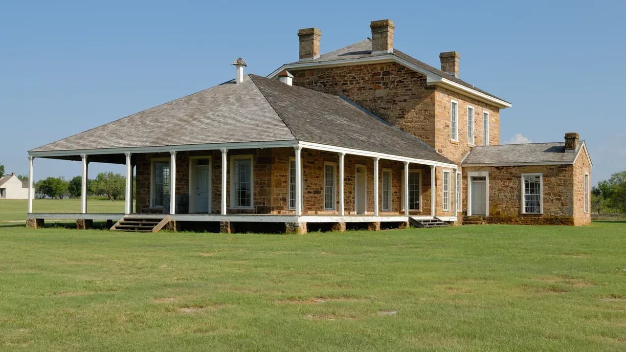
The 2020 Census counted 4,184 people in the city. A driver coming in on Main Street passes a pale stone courthouse, a few blocks of old storefronts and, just south of downtown, a state park with a two-story stone hospital standing in an open field. That field was Fort Richardson. The town and the fort grew up side by side, and the record of one cannot be told without the other. [1] [20]
Before 1858: Lost Creek and Mesquiteville
Before White settlement, the Handbook of Texas says, the land that became Jack County was a borderland between the Caddo peoples to the east and the Comanches to the west. Spaniards under Coronado may have crossed it in the sixteenth century. They left no settlement. [2]
The county lay inside the Peters colony, the land grant of the Texan Emigration and Land Company. Settlers began arriving by 1855, mostly from the middle South: Alabama, North Carolina, Arkansas, Missouri and Kentucky, many by way of Smith County or other parts of Texas. The first settlement in the county, Keechi, was established by 1856. [2]
Along the banks of Lost Creek a small community of farmers took root and spread south over the pastureland toward the West Fork of Keechi Creek. As the buildings multiplied, including a church and a schoolhouse, settlers began calling the place Mesquiteville. Texas A&M AgriLife’s county history says the name came from the large mesquite trees there; the Handbook does not give a reason. [1] [18]
The legislature created Jack County in 1856. The Handbook dates the act to August 27, 1856; the AgriLife county page gives August 14 and says the county was originally part of Cooke County. We print both dates. The county was named for William H. and Patrick C. Jack, Georgia-born lawyers who came to Texas in the early 1830s. The Handbook says 1830; the AgriLife page says 1832. [2] [8] [9] [18]
Neither brother ever saw the county. Patrick Jack was one of the men whose arrest at Anahuac in 1832 helped set off the Anahuac Disturbances, and William helped write the Turtle Bayou Resolutions that July. Both served in public office under the Republic. Patrick died of yellow fever in Houston on August 4, 1844, and William died of the same illness sixteen days later, on August 20, in Brazoria County. The Handbook notes that Jack County is the only county of that name in the United States. [8] [9] [2]
In 1858 Mesquiteville was chosen county seat and renamed Jacksborough, or Jacksboro, for the brothers. AgriLife says the first courthouse was completed on August 17, 1858. [1] [18]
1858–1861: the Butterfield stage and a vote against secession
The first stagecoach of the Butterfield Overland Mail reached Jacksboro in 1858. The line ran semiweekly mail and passengers between St. Louis and San Francisco from September 15, 1858, to March 1, 1861. Its Texas route came east from Fort Belknap to Murphy’s station near present Graham, then nineteen miles on to Jacksboro, then toward Gainesville, Sherman and the Red River. Regular postal service began in 1859. [1] [10]
AgriLife’s county history adds that the original route passed about three miles south of Jacksboro until a narrow passage through a cliff was deliberately blocked with boulders, forcing the mail through town. The Handbook does not tell that story, and this article cannot confirm who blocked the passage or when. [18]
Jack County was a frontier county, and the Handbook says a plantation economy never developed there. It also says that on the eve of the Civil War thirty-seven enslaved people lived in the county. The number is small. It is not zero, and it belongs in the record. [2]
The county’s first newspaper, the Whiteman, founded in 1860 by Harris A. Hamner, argued the Southern cause. The voters did not follow it. In February 1861 Jack County voted 76 to 14 against secession, one of the few Texas counties to do so. [2] [1]
1861–1867: the town that nearly emptied
Jack County saw no Civil War battles. What it saw, the Handbook says, was the result of federal troops leaving the frontier. Raids became frequent, and many residents fled east. The 1860 census counted 1,000 people in the county; by 1870 there were 694. [2]
The Handbook’s description of the town at the end of the war is blunt. Jacksboro was the most westward settlement still standing in Texas, it had been devastated by raids, and it consisted of fewer than a dozen ramshackle buildings, most of them in ruins. [1]
The raids are told in the Handbook mostly from the settlers’ side, because that is the side that kept the county records. The Kiowa biographies in the same Handbook describe the other side of those years: a people losing their range to settlement, bound by treaties that shrank their land to a reservation, and divided after the death of their principal chief, Dohäsan, in 1866. Both things were true at once on this frontier. [5] [7]
1867–1878: Fort Richardson
The army came back. When it came back is one of the places where the sources do not agree, and we print all of them. The 1936 Texas Centennial markers at the fort say it was established by the War Department on November 26, 1867. The Handbook’s Fort Richardson entry says it was officially established in February 1868. The Jack County entry says it was established in 1867 and completed in 1869; the Jacksboro entry dates its completion to 1870. [14] [15] [3] [2] [1]
The post was named for Union general Israel B. Richardson, who was killed at Antietam in September 1862. It occupied some 300 acres on Lost Creek, half a mile south of Jacksboro, and was never stockaded. Eventually fifty-five buildings of stone, pickets and cottonwood lumber went up, at an estimated cost to the government of $800,000. A War Department survey of the reserve dated August 8, 1870, shows the town’s small grid of blocks just across Lost Creek from the post. [3] [14] [22]
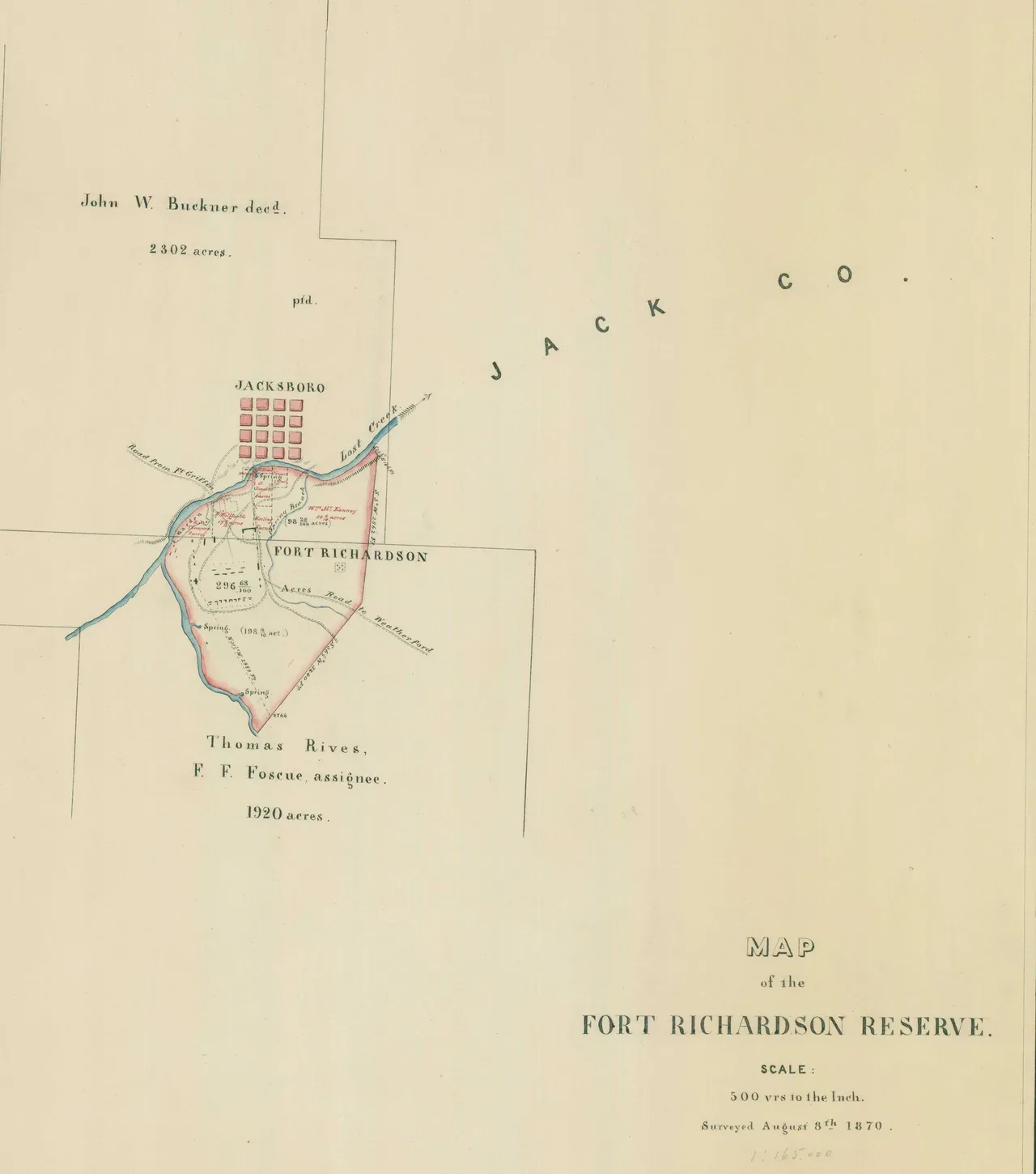
“Map of the Fort Richardson Reserve,” from the War Department map collection at the National Archives. Its notes read “Surveyed August 8th 1870.” The small red grid labeled Jacksboro sits just north of the reserve across Lost Creek, which is how close the town and the post were. The land south of the reserve is marked “Thomas Rives, F. F. Foscue, assignee.” This crop shows the map’s center and title. U.S. National Archives and Records Administration (NAID 137930250), public domain.
Seventy miles from Indian Territory and 120 miles from Fort Sill, Richardson was the northernmost army post in Texas and the anchor of a line that included Fort Griffin and Fort Concho. The Handbook calls it, from 1868 to 1873, the most important post in Texas. In 1872 it had 666 officers and men, the largest garrison of any military installation in the United States. [3]
The Sixth Cavalry, the Fourth Cavalry and the Eleventh Infantry each made it their regimental headquarters in turn, and elements of the Tenth Cavalry and the Twenty-fourth Infantry served there too. Soldiers escorted wagon trains, protected herds, chased deserters and outlaws, oversaw Reconstruction elections and, above all, scouted for raiders. Most scouts found nothing. Some did not come back whole: in July 1870 Capt. Curwin B. McClellan and fifty-six men of the Sixth Cavalry were ambushed near the Little Wichita River by Kiowas and Comanches led by Kicking Bird, and thirteen of the soldiers later received the Medal of Honor. [3]
With the post next door, the town came back. The Handbook says the population of the county seat rose to several hundred and Jacksboro became the county’s trading center. By the time the Handbook’s town entry takes inventory, Jacksboro had three flour mills, a brickyard, a cotton gin, two churches, a school and a newspaper. [1]
May 18, 1871: Salt Creek Prairie
In May 1871 Gen. William T. Sherman toured the Texas frontier to judge complaints that Indians from the Fort Sill reservation were raiding the state. He traveled with a small escort, saw no Indians and, the Handbook says, was convinced the Texans’ reports were exaggerated. He reached Fort Richardson on May 17. [4]
He had passed closer to danger than he knew. More than a hundred Kiowa, Comanche, Kiowa-Apache, Arapaho and Cheyenne men had crossed the Red River on May 15. Their leaders were Satank, Satanta, Big Tree and Maman-ti. On May 17 they lay hidden on the Salt Creek Prairie in Young County, about twenty miles west of the fort, and let Sherman’s party pass. Indian informants later said Maman-ti had foretold that the second group of travelers, not the first, should be attacked. [4] [19]
On May 18 they attacked a wagon train belonging to freight contractor Henry Warren on the old Butterfield road. The wagon master and six teamsters were killed. The Kiowas lost one man dead and five wounded. The sources do not agree on how many teamsters got away: the Handbook’s raid entry says three escaped, its Satank entry says five survived and reached the fort, and True West magazine’s account says two men, including the wounded Thomas Brazeal, walked the twenty miles through rain to bring the news. [4] [7] [19]
Brazeal told his story to Sherman and to Col. Ranald S. Mackenzie, the post commander, that night. Sherman sent Mackenzie after the raiders and went on to Fort Sill. There, the Handbook says, Satanta boasted to the agent, Lawrie Tatum, that he had led the raid and named Satank and Big Tree as his companions. On May 27 Sherman arrested all three on the porch of the post commander’s quarters and ordered them sent to Jacksboro to be tried for murder in a civil court. [4] [5]
They left Fort Sill in chains on June 8. Satank, an elderly leader of the Kiowa warrior society the Handbook calls the Koitsenko, would not go. He sang his death song under a blanket, worked his hands free of the cuffs, attacked a guard with a hidden knife and was shot down beside the road. The Handbook says no Kiowa claimed the body for fear of reprisal, and he was buried without ceremony at Fort Sill. [7] [4]
July 1871: the trial in Jacksboro
Satanta and Big Tree reached Jacksboro on June 15 and were held at Fort Richardson. True West’s account says eight lawyers asked District Judge Charles Soward not to hold court in Jacksboro at all, for fear of an Indian attack. He refused. Samuel W. T. Lanham, who later became governor of Texas, prosecuted. Thomas Ball and Joseph A. Woolfolk defended. [19]
The trials were held separately on July 5 and 6, on the top floor of the two-story courthouse. School was let out so people could attend. The defense argued that Texas had no right to try men who were wards of the federal government; the judge overruled it. Witnesses included Mackenzie, Brazeal and the agency interpreter who testified to Satanta’s boast. The defense called no witnesses. The jury took about half an hour to convict Big Tree, and the next day convicted Satanta. Both were sentenced to hang; the Jack County entry gives the execution date as September 1, 1871. [4] [19] [2]
Satanta spoke for himself, through an interpreter. As True West quotes the newspaper report, he told the jury that if they let him live he could control his people, and that if he died “it will be like a match put to the prairie.” The same article says plainly that there was no way two Kiowas could get a fair trial in that place and time, and also that the evidence of their guilt was clear. Both of those sentences are worth keeping. [19]
The Handbook calls the case the first time Indian chiefs were tried in a civil court. Its Fort Richardson entry puts it more narrowly, as the first time Indians were tried in a Texas civil court. Either way, it made Jacksboro a national story. [5] [3] [1]
It did not end with a hanging. Under pressure from federal officials and supporters of the Quaker-run peace policy, and out of fear of Kiowa retaliation, Gov. Edmund J. Davis commuted both sentences to life in prison, against the wishes of Sherman and of many Texans. The two men were sent to the state penitentiary at Huntsville; the Handbook’s Big Tree entry says they went in September 1871, and True West gives the date as October 16. They were paroled in 1873. [5] [6] [19]
Their stories split after that. Satanta was seen with war parties during the Red River War, was rearrested in 1874 and returned to Huntsville. On October 11, 1878, he died after jumping from a prison window; the Handbook calls it suicide. In 1963 his grandson, the Kiowa artist James Auchiah, had his remains moved from the prison cemetery to Fort Sill, next to Satank. Dock Line’s history of Huntsville tells the story of the prison town where he died. [5]
Big Tree spent the rest of his long life counseling peace. The Handbook says he helped bring the first Baptist mission to the Kiowa reservation, joined the Rainy Mountain Baptist Church by 1897 and served it as a deacon for thirty years. He died at his home in Anadarko on November 13, 1929, and is buried in the Rainy Mountain Cemetery. [6] [19]
The raid and the trial changed army policy. Sherman, now convinced, ordered offensive operations against Indians found off the reservation. Over fifteen months Mackenzie led four major expeditions out of Fort Richardson. One of them, in late 1872 on the North Fork of the Red River, attacked the camp of the Comanche chief Mow-way, killing fifty warriors and capturing 130 women and children. The campaigns ended in the Red River War of 1874–75 and the final military defeat of the Comanches and Kiowas on the southern plains. [4] [3]
1875–1910: newspapers, rails and a stone depot
The Frontier Echo was first issued in Jacksboro on June 30, 1875. It followed the cattle frontier west, moving to Fort Griffin by 1879 and later to Albany. By the late 1880s the Jacksboro Gazette had taken its place in town. [11] [1]
With the frontier quiet, the army abandoned Fort Richardson in May 1878. The 1936 markers give the date as May 23, 1878; the Atlas transcription of the highway marker reads 1879, while the marker’s photographed inscription on the Historical Marker Database reads 1878. Most of the buildings fell into ruins. The city of Jacksboro kept up a few, especially the hospital and one officers’ quarters. [3] [14] [15] [23]
The county filled up fast after the raids ended. Jack County had 6,629 residents in 1880, ten times the 1870 count, and 9,740 by 1890. Cattle came first; the first drive north out of the county was made in 1866. Large-scale farming followed in the late 1870s, with corn and later oats, wheat and cotton. [2]
The Chicago, Rock Island and Texas Railway reached Jacksboro on August 24, 1898. The town’s first depot was built that year of native stone by the Risley Brothers of Jacksboro, on a site bought from F. F. Foscue, a legislator who owned the former Fort Richardson lands. The state marker there notes that Edith Wilmans, a local rancher whom the marker calls Texas’ first woman legislator (1923), often traveled from the station. The Gulf, Texas and Western arrived in 1910, and Jacksboro became the main shipping point for the county’s farmers and ranchers. In 1940 the Chicago, Rock Island and Gulf bought the Gulf, Texas and Western track between Jacksboro and Seymour. [2] [16] [1] [12]
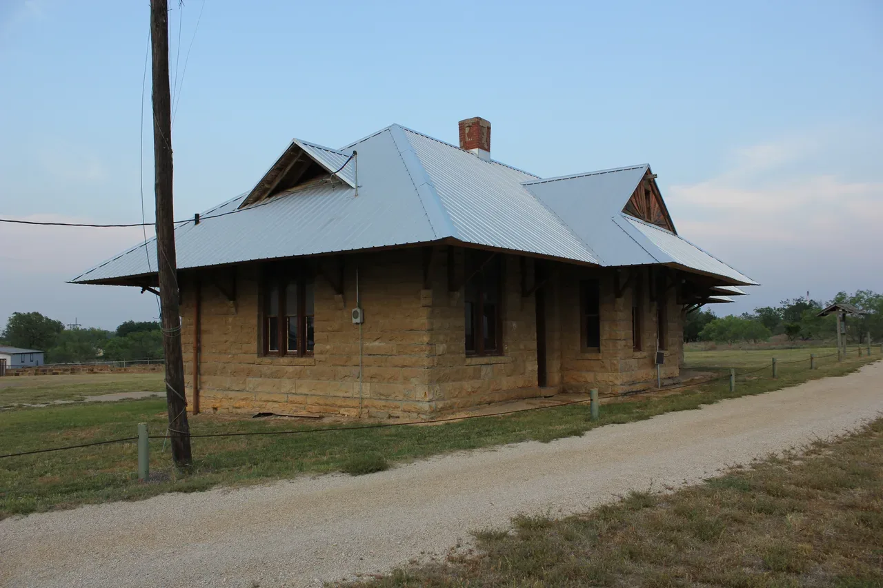
Jacksboro’s first railroad depot, built in 1898 of native stone for the Chicago, Rock Island and Texas Railway, photographed in May 2013 at the end of Depot Street by the east gate of Fort Richardson. It is a Recorded Texas Historic Landmark. Nicolas Henderson, CC BY 2.0, via Wikimedia Commons.
AgriLife’s county history records a first of another kind: on September 8, 1907, Tom M. Marks organized a boys’ corn club in Jacksboro, handing out a gallon of improved seed corn to each of 111 boys. The next year the club exhibited at the first county fair. AgriLife says the club grew into the first 4-H club in Texas, and the Jack County Museum is in Marks’s former home. The Handbook entries used here do not address that claim, so it is given as AgriLife states it. [18]
1900–1942: two counts, oil and the Lost Battalion
Even the town’s early population comes in two versions on one Handbook page. The narrative says Jacksboro reached 1,000 people in 1900 and had nearly doubled by 1930. The Texas Almanac table on the same page lists 751 for 1890, 1,311 for 1900 and 1,837 for 1930. The page does not explain the difference, and we print both. [1]
Oil was found near Bryson in 1923, and wells near Bryson and Antelope added oilfield service work to the county seat’s farm trade. The county as a whole was losing people after 1915, the Handbook says, because of a string of agricultural busts. Oil money helped some cash-poor farmers through the Depression. Many others sold out. [1] [2]
In 1936 the Texas Centennial Commission bought the old fort, and the city and the Jack County Historical Society maintained it. On November 25, 1940, Battery F, 2nd Battalion, 131st Field Artillery of the Texas National Guard mobilized at the fort for active duty. [3] [17]
The battalion sailed from San Francisco in November 1941 and was at sea when Pearl Harbor was attacked. It was sent to Java, where it was captured in March 1942 when the Dutch surrendered. Because it was never evacuated, it became known as the Lost Battalion. Its men were held in prison camps across Asia for three and a half years and forced to work on the Burma-Siam railway, the “Railroad of Death.” [13] [17]
The two sources at the fort do not agree on the toll. The Handbook’s Fort Richardson entry says “most of the 63 deaths” happened while building the railway. The 1968 state marker at the park says “8 of original 63 died,” meaning eight of Battery F’s original sixty-three men. This article could not reconcile the two and prints both. [3] [17]
1964–2025: a landmark and a modern count
Fort Richardson was declared a National Historic Landmark in 1964. In 1968 the Texas Parks and Wildlife Department took over the grounds and began extensive restoration. It is now Fort Richardson State Park, Historic Site and Lost Creek Reservoir State Trailway. [3] [1]
The town passed 4,000 people in the mid-1980s, when it held just over half the county’s population. It counted 3,350 in 1990, 4,533 in 2000 and 4,184 in 2020. The Handbook counted 248 businesses in 2023. The town holds an annual festival under its old name, Mesquiteville Days. [1]
The Census Bureau’s estimates program starts from a slightly different 2020 base of 4,173 for the city, as it adjusts for boundary and other changes, and estimated 4,735 residents on July 1, 2025. The count and the estimate are different measures, and we print both rather than blend them. [21] [20]
The complete story of Jacksboro
It is the story of farmers on Lost Creek who named their settlement for the mesquite and then gave it up to honor two lawyers who never saw it. It is the story of a stage stop on the Butterfield road and of a county that voted against secession and still counted thirty-seven enslaved people. It is the story of a town reduced to a dozen broken buildings and brought back by an army post next door. It is the story of seven teamsters killed on the Salt Creek Prairie, a Kiowa elder shot down by the road, and two men tried for their lives upstairs in a frontier courthouse, one of whom died in a Huntsville prison and one of whom died a Baptist deacon. It is the story of a stone depot, a boys’ corn club and a battery of Texans who left from the old parade ground for Java. The fort’s hospital is still standing. So is the town.
Questions people ask
Why is it called Jacksboro? The town was first called Mesquiteville. When it became county seat in 1858 it was renamed Jacksborough, or Jacksboro, for William H. and Patrick C. Jack, brothers who fought in the Texas Revolution. The county is named for them too. [1] [2]
Were Satanta and Big Tree hanged in Jacksboro? No. A Jacksboro jury convicted both men of murder in July 1871 and they were sentenced to hang, but Gov. Edmund J. Davis commuted the sentences to life in prison. Both were paroled in 1873. Satanta was later returned to prison and died at Huntsville in 1878; Big Tree lived until 1929. [5] [6] [4]
When was Fort Richardson built? The sources differ. The 1936 state markers say it was established November 26, 1867. The Handbook’s fort entry says it was officially established in February 1868; its Jack County entry says the post was completed in 1869, and its Jacksboro entry says 1870. The army left in May 1878. [14] [3] [2] [1]
What happened to the Lost Battalion? Battery F of the 131st Field Artillery mobilized at Fort Richardson in November 1940, was captured on Java in March 1942 and spent three and a half years as prisoners of war, many of them on the Burma-Siam railway. The Handbook and the state marker give different death figures, and both are printed above. [13] [17] [3]
What is Jacksboro’s ZIP code? 76458. Jacksboro is the county seat of Jack County, at U.S. 281 and U.S. 380. [23] [1]
Sources
David Minor, “Jacksboro, TX,” Handbook of Texas Online, Texas State Historical Association, revised October 13, 2026. tshaonline.org/handbook/entries/jacksboro-tx. The entry’s bibliography includes Thomas F. Horton, History of Jack County (193-?); Ida Lasater Huckabay, Ninety-Four Years in Jack County (1949; centennial ed., 1974); and Carl Coke Rister, “The Significance of the Jacksboro Indian Affair of 1871,” Southwestern Historical Quarterly 29 (January 1926).
Robert Wayne McDaniel, “Jack County,” Handbook of Texas Online, revised May 28, 2021. tshaonline.org/handbook/entries/jack-county. Its bibliography includes Gilbert Webb, comp., Four Score Years in Jack County, 1860–1940 (1940).
Allen Lee Hamilton, “Fort Richardson,” Handbook of Texas Online, revised October 13, 2026. tshaonline.org/handbook/entries/fort-richardson. Its bibliography includes Hamilton, Sentinel of the Southern Plains: Fort Richardson and the Northwest Texas Frontier, 1866–1878 (TCU Press, 1988).
Allen Lee Hamilton, “Warren Wagontrain Raid,” Handbook of Texas Online, revised April 1, 2021. tshaonline.org/handbook/entries/warren-wagontrain-raid. Its bibliography includes Benjamin Capps, The Warren Wagontrain Raid (1974), and W. S. Nye, Carbine and Lance (1937).
Brian C. Hosmer, “Satanta,” Handbook of Texas Online, revised February 10, 2021. tshaonline.org/handbook/entries/satanta.
Brian C. Hosmer, “Big Tree,” Handbook of Texas Online, revised September 30, 2020. tshaonline.org/handbook/entries/big-tree.
Brian C. Hosmer, “Satank,” Handbook of Texas Online, revised January 27, 2021. tshaonline.org/handbook/entries/satank.
Thomas W. Cutrer, “Jack, William Houston,” Handbook of Texas Online, revised April 25, 2019. tshaonline.org/handbook/entries/jack-william-houston.
L. W. Kemp, “Jack, Patrick Churchill,” Handbook of Texas Online, revised April 25, 2019. tshaonline.org/handbook/entries/jack-patrick-churchill.
Rupert N. Richardson, “Butterfield Overland Mail,” Handbook of Texas Online, revised November 1, 1994. tshaonline.org/handbook/entries/butterfield-overland-mail.
“Frontier Echo,” Handbook of Texas Online, revised January 1, 1995. tshaonline.org/handbook/entries/frontier-echo.
Nancy Beck Young, “Chicago, Rock Island and Gulf Railway,” Handbook of Texas Online, revised October 14, 2020. tshaonline.org/handbook/entries/chicago-rock-island-and-gulf-railway.
E. R. Milner, “Lost Battalion,” Handbook of Texas Online, revised December 28, 2022. tshaonline.org/handbook/entries/lost-battalion.
Texas Historical Commission, Atlas, “Fort Richardson,” marker 2008 (1936 Centennial marker, Fort Richardson State Historical Park). atlas.thc.texas.gov/Details/5237002008.
Texas Historical Commission, Atlas, “Fort Richardson,” marker 2009 (1936 Centennial highway marker, U.S. 281). atlas.thc.texas.gov/Details/5237002009.
Texas Historical Commission, Atlas, “Jacksboro’s First Railroad Depot,” marker 2700 (1974, Recorded Texas Historic Landmark). atlas.thc.texas.gov/Details/5237002700.
Texas Historical Commission, Atlas, “Mobilization Site of Lost Battalion,” marker 3429 (1968). atlas.thc.texas.gov/Details/5237003429.
Texas A&M AgriLife Extension Service, “Jack County,” county office page (county history). agrilifeextension.tamu.edu/counties/jack-county.
Johnny D. Boggs, “Judgment at Jacksboro,” True West Magazine, October 1, 2003. truewestmagazine.com/article/judgment-at-jacksboro.
U.S. Census Bureau, QuickFacts, Jacksboro city, Texas. census.gov/quickfacts/fact/table/jacksborocitytexas.
U.S. Census Bureau, Population Estimates Program, “City and Town Population Totals: 2020–2025” (sub-est2025.csv), Jacksboro city, Texas: April 1, 2020, estimates base 4,173; July 1, 2025, estimate 4,735. census.gov sub-est2025.csv.
“Map of the Fort Richardson Reserve, Texas,” surveyed August 8, 1870, War Department Map Collection, Record Group 77, U.S. National Archives (NAID 137930250). catalog.archives.gov/id/137930250.
Historical Marker Database, “Fort Richardson” (marker 2009, 302 South Main Street, Jacksboro, TX 76458). hmdb.org/m.asp?m=138158.