The History of Fort Davis, Texas
Fort Davis, Texas (ZIP 79734) grew up beside an army post founded on Limpia Creek in 1854. It lost the Presidio County seat to the railroad town of Marfa in 1885, then got the legislature to create Jeff Davis County around it in 1887.
Editor’s note. This is the twentieth installment of “Texas Towns: The Stories Behind the Map.” The last one stopped in Castroville, which turned down the railroad and lost its county seat to a town on the tracks. This one goes five hundred miles west, into the mountains of the Trans-Pecos, to a town that lost its county seat to a railroad town too, and then got a county seat back by persuading the legislature to draw a new county around it. Fort Davis never did get a railroad. It still has the fort.
Fort Davis, Texas, sits on Limpia Creek where State Highways 17 and 118 meet, at the eastern foot of the Davis Mountains. It is eighty miles northeast of Presidio, 175 miles southeast of El Paso, and twenty-three miles northeast of Marfa, and it is the county seat of Jeff Davis County. The mailing ZIP is 79734. No railroad has ever reached the town. The Southern Pacific went through Marfa instead, and when another line proposed coming in around 1908, local people protested and it was never built. [1] [2]
The Census Bureau does not count Fort Davis as a city. It is a census-designated place, an unincorporated community, and the 2020 Census counted 1,024 people there. The town grew up beside an army post, and the post, restored, is now a national historic site on the town’s northern edge. [10] [4]
1849: Painted Comanche Camp and the road to El Paso
The Handbook of Texas says the first European known to have entered what is now Jeff Davis County was Antonio de Espejo, who came up Limpia Canyon in 1583. After that the mountains were left to the Mescalero Apaches for another two and a half centuries. Long before either, prehistoric people camped in these mountains; the county entry mentions a cache of some 1,200 arrow points dated to around A.D. 1000. [2]
American interest arrived with the need for a road west. In March 1849 Lieutenants William H. C. Whiting and William F. Smith left San Antonio looking for a route to El Paso. In the Davis Mountains about 200 Apaches met them and escorted them to a village the explorers called Painted Comanche Camp, perhaps mistaking their hosts for Comanches. Whiting named Wild Rose Pass and Limpia Creek, from the Spanish word for “clean.” That June, Lt. Col. Joseph E. Johnston opened the first wagon road from San Antonio to El Paso through the mountains. Gold-seekers bound for California used it, and the county entry says 2,000 emigrant wagons traveled it in 1858. [2]
In 1850 Henry Skillman won the contract to carry the mail from San Antonio to El Paso. A stage stand went up near the site of the future town. E. P. Webster, from Illinois, and Diedrick Dutchover, a Belgian immigrant who had fought in the Mexican War, rode with William A. A. “Big Foot” Wallace to escort the first mail coach. Webster stayed on as the first master of the stage station in Limpia Canyon, and the Handbook says he may have been the first White settler in the area. [1] [2]
October 1854: a post named for the secretary of war
The army wanted a fort where the El Paso road crossed the Apache and Comanche trails into Mexico. On May 19, 1854, John James, whom the county entry calls a San Antonio land speculator and the entry on the fort a San Antonio surveyor, filed on a section of land that took in Painted Comanche Camp, then leased it to the United States for $300 a year for twenty years. Bvt. Gen. Persifor F. Smith picked the site himself for its “pure water and salubrious climate.” Six companies of the Eighth U.S. Infantry under Lt. Col. Washington Seawell reached Painted Comanche Camp on October 7, 1854, and the county entry dates the order establishing the post to October 23. It was named for Jefferson Davis, then the U.S. secretary of war. [3] [2]
A town came with it. A rough settlement grew up beside the post, first called Chihuahua; the county entry places it south of the fort and the town entry southwest. The county entry describes its people without flattery: merchants, gamblers, saloonkeepers, prostitutes, and adventurers. Dutchover started a small sheep ranch near the fort. Manuel Músquiz, reportedly a political refugee from Mexico, ranched in the canyon southeast of the post that still carries his name. [2] [1]
1861–1867: war, Nicolás, and an empty fort
When Texas left the Union, federal troops gave up Fort Davis under orders from Brig. Gen. David E. Twiggs, and Col. John R. Baylor’s Confederate cavalry took it over in April 1861 without firing a shot. The Mescalero Apaches, the county entry says, used the disruption to step up their attacks on the Whites who had come into their country. [3] [2]
The Confederates tried to win over the Mescalero chief Nicolás. On the way back from a meeting in El Paso he grabbed an officer’s gun at Barrel Springs and escaped; two troopers who chased him were killed. A few days later his warriors attacked Fort Davis, killed three people, and drove off the stock. Lt. Ruben E. Mayes and fourteen men went after him through Musquiz Canyon and south toward the Rio Grande. On August 9 the Mescaleros drew them into a narrow canyon and killed every man in the detachment except a Mexican scout who came back to report it. The bodies were never found, and the Handbook says the exact place is still unknown. [2]
The Confederates then left, putting Dutchover, who had stayed neutral, in charge of the post. Nicolás attacked almost at once. The town entry says Dutchover, a Mexican woman with two children, and four Americans hid on a roof for three days while the post was looted, then slipped out at night and walked eighty miles to Presidio, leaving behind one American who had fallen ill. When the stage arrived, it found him dead on the roof, apparently of natural causes. The county entry tells it more briefly and counts four or five companions. For the next five years the fort stood empty, and the Handbook’s entry on the post says Indians used the wood from its buildings for fuel. [1] [2] [3]
1867–1891: the Black regiments and the most important town in the Trans-Pecos
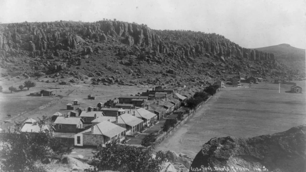
Federal troops came back in 1867. The entry on the fort says Lt. Col. Wesley Merritt led them in June and began building a new post; the county entry dates the return of four troops of the Ninth U.S. Cavalry to July 1. From 1867 to 1885 the garrison was made up mostly of Black enlisted men under White officers, in the Ninth and Tenth Cavalry and the Twenty-fourth and Twenty-fifth Infantry, and the Handbook credits them with a notable record against the Apaches and Comanches. By the mid-1880s the post had quarters for more than 600 men and more than sixty stone and adobe buildings. [3] [2]
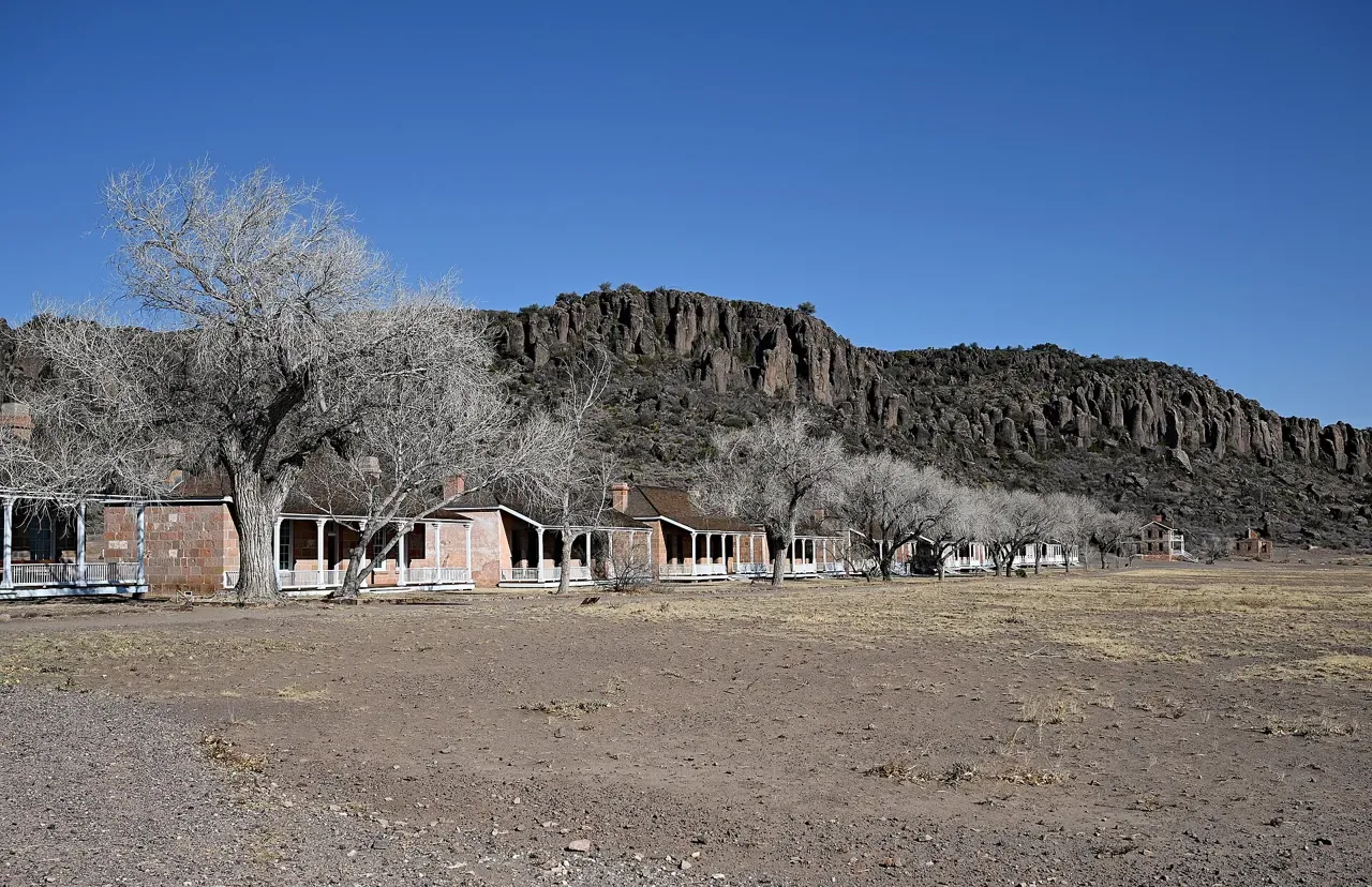
Officers’ Row at Fort Davis National Historic Site in 2025, under the same cliffs that appear in the 1885 photograph at the top of this article. These are restored quarters of the post the army rebuilt after 1867, not buildings of the civilian town. P. Hughes, CC BY 4.0, via Wikimedia Commons.
In September 1879 the Apache leader Victorio began a series of attacks west of Fort Davis. Col. Benjamin H. Grierson ran the campaign against him from the post. Victorio retreated into Mexico, where he and many of his followers were killed by Mexican troops in October 1880. The county entry says that by 1880 the army had “virtually eliminated” the Apache threat. [3] [2]
One of the officers at Fort Davis in those years was Henry O. Flipper, born a slave in Georgia in 1856 and, in 1877, the first Black graduate of West Point. After fighting in the Victorio campaign he was made quartermaster and commissary at Fort Davis. When Col. William R. Shafter took command in 1881, he relieved Flipper as quartermaster at once. Flipper later called it a systematic plan of persecution, and the Handbook says civilians at the post reportedly warned him of a plot by White officers to force him out. When post funds went missing from his quarters, he tried to hide the loss until he could replace the money. Shafter filed charges. A court-martial acquitted him of embezzlement but convicted him of “conduct unbecoming an officer and a gentleman,” and he was dismissed from the army on June 30, 1882. Flipper maintained his innocence for the rest of his life. In 1976 the Army changed his discharge to honorable, and on February 19, 1999, President Bill Clinton pardoned him. [5]
The return of the troops is what made the town. The Handbook calls Fort Davis in those years “the most important town in the Trans-Pecos country,” at the crossing of two important trails. Storekeeper Dan Murphy, butcher Sam R. Miller, and baker Whitaker Keesey came with the soldiers; Keesey became the town’s most influential merchant and his brother O. M. Keesey its first county judge. Charles Mulhern, an ordnance sergeant from County Donegal, Ireland, stayed and bought land, and General Grierson retired to Fort Davis in 1890. In the 1880s cattlemen poured into the region, many of them escaping the Texas fever epidemic elsewhere in the state. [1] [2]
The county entry names others who settled in and around Fort Davis in those years, among them Tiburcio Granado, José Salsido, Felipe Domínguez, Nick Mersfelder, Pat Dolan, Robert S. Sproul, and David and Jesse W. Merrill. Mexican Americans were a large share of the county from the start. In 1890 more than a fifth of Jeff Davis County’s people had been born in Mexico, and in 1930 the census classified 58 percent of the county’s 1,800 residents as “Mexican.” [2]
The town also kept a legend, and the Handbook prints it as a legend. A young woman named Dolores Gavino Doporto was engaged to a goatherd named José, and she signaled him by building a fire every Thursday night on the low mountain south of town. José was killed by Mescaleros shortly before the wedding. Dolores kept climbing the mountain to build her fire for thirty or forty years, the story goes, and when she died in 1893 she was buried near her path. The mountain is called Dolores Mountain. [1]
1871–1887: a county seat lost and a county made
Presidio County, which then took in all of present Jeff Davis and Brewster counties, was finally organized in 1871, with Fort Davis as its seat. The town entry says April 1871; the county entry gives May 12, 1871. The town entry adds that the courthouse later burned and took the records of that election with it. [1] [2]
Then the railroad came through somewhere else. The county entry says the Southern Pacific built through the area in 1882; the town entry puts it twelve years after 1871. Either way it ran through Marfa, and people in Marfa thought the railroad town should have the courthouse. With no records of the first election to point to, they disputed it. A new election was held on July 14, 1885. The results were disputed, too, and Marfa won. By then Fort Davis had an estimated 2,000 people, three lawyers, a milliner, two saloons, two churches, gristmills and cotton gins, and a weekly paper called the Apache Rocket. [2] [1]
The town did not wait. Its residents called at once for a new county, and on March 15, 1887, the legislature created Jeff Davis County with Fort Davis as the seat. The county entry quotes one legislator: “Thank God that at last we have a Texas county named in honor of the president of the Confederacy.” The quarrel with Marfa went on over the county line, ended up in court, and was not settled until January 1905, when Jesse W. Merrill and S. A. Thompson surveyed a new boundary. [2]
1888–1912: a preacher on horseback and a camp meeting
The Handbook counts two churches in Fort Davis in 1885 but does not name them. The best-recorded part of the town’s faith history begins three years later. William Benjamin Bloys, a Tennessee-born Presbyterian home missionary whose lung ailment had kept him from serving overseas, moved to Fort Davis on his doctor’s advice in 1888. He started Presbyterian congregations through the Davis Mountains and the Big Bend, served as a volunteer chaplain to the army post until it closed in 1891, and held services in churches, homes, and cow camps for anyone who asked, of any denomination. [1] [7]
The ranches were too far apart for families to worship together, and Bloys could rarely reach them all at once. In October 1890, while visiting the family of John Z. Means, he worked out a plan to bring them together once a year. On October 10, 1890, forty-three people gathered at Skillman’s Grove, about sixteen miles southwest of Fort Davis, for a two-day camp meeting of preaching, Bible teaching, and visiting. They met under a brush arbor, then for years in a canvas tent. The camp association bought its land in 1902 and built a permanent tabernacle in 1912. [6]
The Handbook’s entry on the meeting, last revised in 1994, describes it as a five-day gathering each August, usually from the second Tuesday to the following Sunday, sponsored by Presbyterians, Methodists, Baptists, and Disciples of Christ. Nothing can be bought or sold on the grounds. Food and water are free, guests may contribute toward the costs, and the cooking is still done ranch-style on open fires. Average attendance was more than 3,000 by 1988. Joe Evans, one of the original members, helped start a chain of similar camp meetings in New Mexico, Arizona, Nebraska, and Nevada, and the Hill Country Cowboy Campmeeting near Ingram was patterned after Bloys as well. Bloys died at Fort Davis on March 22, 1917, and the gathering was renamed for him. [6] [7]
1891–1946: after the army left
The army abandoned the post in 1891, and the town shrank. The Handbook estimates 1,200 people in the early 1890s and 500 by 1896. It grew back to 1,061 in 1904 and 1,100 in 1914. Around 1900 the cool summers and the mountains made Fort Davis a summer resort for wealthy families from the Gulf Coast. [3] [1]
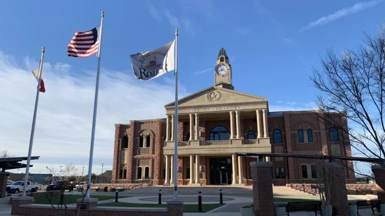
Around 1908 the Kansas City, Mexico and Orient Railway proposed a line to Fort Davis. The Handbook says local people protested that it would bring in “low-class people,” and the line was never built. In 1910 and 1911 the county put up the courthouse that still stands, designed by the Dallas firm the state marker calls L. L. Thurman and Company (the Historical Commission’s courthouse program spells it Thurmon) and built by the Falls City Construction Company of Louisville, Kentucky. The state marker says it replaced “the original 1880 adobe courthouse.” The Handbook’s account of an earlier courthouse that burned and the marker’s 1880 adobe building are not explained in relation to each other in either source, and this article does not guess. [1] [8] [9]
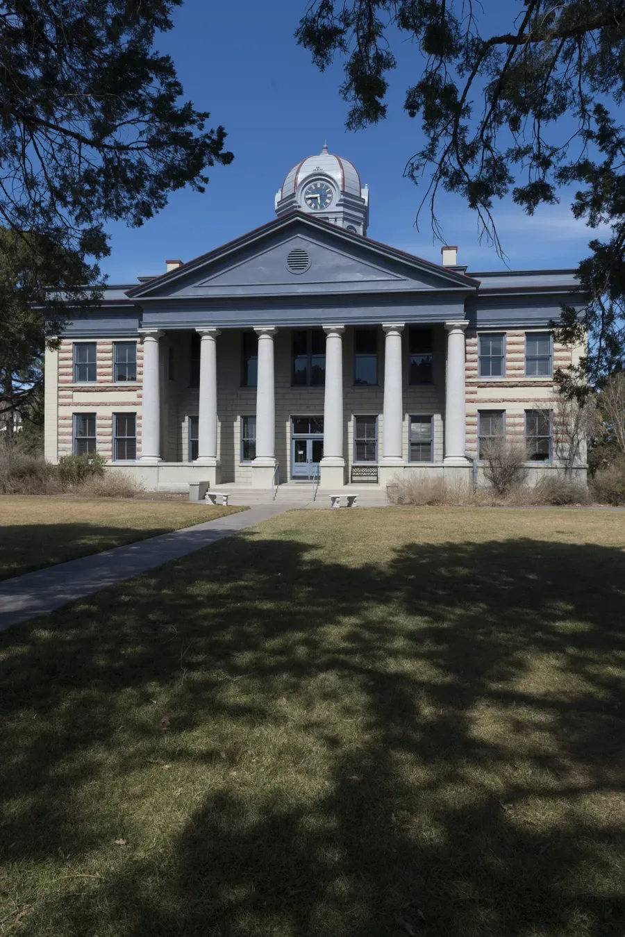
The Jeff Davis County Courthouse in February 2014. The building dates from 1910–1911; its banded pink stone was quarried locally, and its clock tower holds a Seth Thomas clock. It was restored in 2002 and 2003. Carol M. Highsmith, Library of Congress. Public domain.
In the late 1920s a group of Oklahoma oilmen planned to turn Fort Davis into a center for Western movies, with the cowboy star Jack Hoxie, and the Great Depression ended that. The Handbook’s estimates swing widely in these years: 700 in 1928, 1,200 in 1931, 668 in 1933, and 1,000 in 1936. [1]
1946 to now: the fort becomes a park
In May 1946 David A. Simmons of Houston, a former president of the American Bar Association, bought the land where the old fort stood, meaning to restore it as a year-round resort. He died in 1951 before he could. The Handbook dates what came next two ways. The town entry says Fort Davis National Historic Site came into being in September 1961 and was formally dedicated in April 1966. The entry for the site itself says Congress authorized it in 1961 and it became part of the national park system on July 4, 1963. Both agree on 460 acres. The site holds more than twenty original stone and adobe buildings, restored to how they looked in 1880. [1] [4]
The national historic site, Davis Mountains State Park, the Chihuahuan Desert Research Institute’s arboretum on Highway 118, and the University of Texas McDonald Observatory on Mount Locke have made tourism one of the two industries that have carried the county since its founding; ranching is the other. The courthouse was restored with state help, and the work was finished in September 2003. [1] [2] [9]
The population figures do not line up neatly. The town entry gives 1,212 people in 1990 and 1,050 in 2000. The county entry, in a passage built on 2014 Census figures, gives Fort Davis 1,168. The population table attached to the town entry lists 1,201 for 2010, 1,329 for 2019, 1,024 for 2020, and 1,012 for 2021. The 2020 Census count, 1,024, is the one firm number. Those are estimates and a count from different years and methods, and this article prints them as they are. [1] [2] [10]
The complete story of Fort Davis
Fort Davis’s history is the story of a creek of clean water in Apache country and the road the army built past it. It is the story of a post named for a secretary of war who would later lead the Confederacy, and of the gamblers and merchants who camped beside it. It is the story of a Confederate patrol that never came back, of a Belgian sheep rancher who walked eighty miles to Presidio, and of an empty fort stripped for firewood. It is the story of Black soldiers who garrisoned the post for eighteen years, and of a Black lieutenant who was driven out of the army there and cleared more than a century later. It is the story of a town that lost its county seat to a railroad, made a new county instead, and then turned down a railroad of its own. And it is the story of a Presbyterian preacher who got forty-three ranch people to the same grove of trees in October 1890.
The soldiers left in 1891. The town stayed, and so did the fort.
Questions people ask
Is Fort Davis named for the president of the Confederacy? The post was named in 1854 for Jefferson Davis while he was the U.S. secretary of war, seven years before the Confederacy existed. Jeff Davis County, created in 1887, was named for him too, and a legislator at the time said plainly that it honored the president of the Confederacy. [3] [2]
Why doesn’t Fort Davis have a railroad? The Southern Pacific built through Marfa in the 1880s, and around 1908 Fort Davis residents protested a proposed Kansas City, Mexico and Orient line, which was never built. [1]
Who were the soldiers at Fort Davis? Thirteen regiments were headquartered there over the post’s history, nine infantry and four cavalry. From 1867 to 1885 most of the enlisted men were Black soldiers of the Ninth and Tenth Cavalry and the Twenty-fourth and Twenty-fifth Infantry. [3]
Sources
Martin Donell Kohout, “Fort Davis, TX,” Handbook of Texas Online, Texas State Historical Association, revised September 22, 2023. tshaonline.org/handbook/entries/fort-davis-tx. The entry’s bibliography cites Barry Scobee, Old Fort Davis (Naylor, 1947), and The Story of Fort Davis: Jeff Davis County and the Davis Mountains (1936).
Martin Donell Kohout, “Jeff Davis County,” Handbook of Texas Online, revised November 11, 2020. tshaonline.org/handbook/entries/jeff-davis-county. Its bibliography includes Fort Davis Historical Society, Jeff Davis County, Texas (1993), and James Harwood Lundy, The History of Jeff Davis County (M.A. thesis, Sul Ross State College, 1941).
Douglas C. McChristian, “Fort Davis,” Handbook of Texas Online, revised October 22, 2020. tshaonline.org/handbook/entries/fort-davis-qbf15.
Douglas C. McChristian, “Fort Davis National Historic Site,” Handbook of Texas Online, revised October 3, 2019. tshaonline.org/handbook/entries/fort-davis-national-historic-site. Its bibliography includes Robert M. Utley, Fort Davis National Historic Site (National Park Service, 1965).
Bruce J. Dinges, “Flipper, Henry Ossian,” Handbook of Texas Online, revised October 22, 2020. tshaonline.org/handbook/entries/flipper-henry-ossian.
Deborah Bloys Hardin, “Bloys Camp Meeting,” Handbook of Texas Online, revised November 1, 1994. tshaonline.org/handbook/entries/bloys-camp-meeting.
Deborah Bloys Hardin, “Bloys, William Benjamin,” Handbook of Texas Online. tshaonline.org/handbook/entries/bloys-william-benjamin.
Texas Historical Commission, Atlas, “Jeff Davis County Courthouse,” marker 12368, Recorded Texas Historic Landmark, 2000. atlas.thc.texas.gov/Details/5243012368.
Texas Historical Commission, “Jeff Davis County Courthouse,” Texas Historic Courthouse Preservation Program. thc.texas.gov.
U.S. Census Bureau, 2020 Census, Census Designated Places in Texas (TIGERweb), Fort Davis CDP, population 1,024. tigerweb.geo.census.gov.
“View of Fort Davis, Texas 1885,” photograph from the Caleb Henry Carlton papers, Library of Congress Prints and Photographs Division, no known restrictions on publication. loc.gov/item/2016648635.
Carol M. Highsmith, “The 1910 Classical Revival Jeff Davis County courthouse … Fort Davis, Texas,” photograph, February 2014, Library of Congress. lccn.loc.gov/2014631194.