The History of San Augustine, Texas
San Augustine, Texas (ZIP 75972) grew up beside a Spanish mission the Ais people refused to live in. Its founders bought the town site for ninety dollars in 1833 and laid it out in what may have been the first street grid in Texas.
Editor’s note. This is the twenty-first installment of “Texas Towns: The Stories Behind the Map.” The last one went to Fort Davis, an army town in the Trans-Pecos mountains that never got a railroad. This one comes back to extreme East Texas, to the Piney Woods town where the Spanish built a mission in 1717, where Sam Houston was chosen as a delegate in 1833, and where a street grid that may have been the first of its kind in Texas was laid out that same year. Houston’s later home was the subject of the series’ third installment, Huntsville.
San Augustine, Texas, sits where U.S. Highway 96 crosses State Highways 21 and 147, thirty-two miles east of Nacogdoches in north-central San Augustine County. It is the county seat and the largest town in the county. The Handbook of Texas places the town on the Atchison, Topeka and Santa Fe Railway, which reached it under another name in 1901; the newer county entry says the line crossing the county today is the Timberrock Railroad. Ayish Bayou runs two miles west of the courthouse square. The mailing ZIP is 75972. [1] [2]
The 2020 Census counted 1,920 people in the city. That is fewer than lived here in 1950. The Old San Antonio Road, the path Spanish travelers cut through here in 1691, ran past the mission site, and the El Camino Real de los Tejas National Historic Trail still crosses it. The town keeps what that road made: a courthouse square, a grid of streets older than the Republic of Texas, and a set of 1830s and 1840s houses that the Historic American Buildings Survey photographed in 1934 and 1936. [12] [1] [4]
1717: a mission among the Ais
The first people here were the Ais, also written Ayish, a people the Handbook groups with the Hasinai of East Texas. French traders working out of Natchitoches found their main village near the site of the present town, with another just south on Ayish Bayou and a third on the Attoyac River, possibly 500 people in all. The bayou, and later the district and the town’s first post office, took the tribe’s name. [2] [1]
Spain answered the French with missions. Domingo Terán de los Ríos came through in 1691, cutting the path that became the Old San Antonio Road. Father Antonio Margil de Jesús founded Nuestra Señora de los Dolores de los Ais near the Ais village. The Handbook dates that founding to January 1717. The 1936 state granite marker at the site says 1716. The mission was abandoned in 1719, when war between Spain and France threatened the frontier. [3] [5]
The Marqués de San Miguel de Aguayo brought it back. The Handbook’s town entry, the Texas Historical Commission and the 1936 marker all give 1721. The Handbook’s entry on the mission itself says the mission was reestablished in August 1722, when Margil moved it a quarter league east to higher ground beside a stream, and the county entry counts “three years later” from 1719. We print both years. Archeologists from Stephen F. Austin State University confirmed the location in the 1970s and 1980s on a hill by Ayish Bayou, inside the present city limits, though highway construction had destroyed a large part of the site. [1] [4] [3]
As a mission, Dolores failed on its own terms, and the record is plain about why. The Ais would not live there. Inspectors in 1744 found two priests, two soldiers and no Indians in residence; in 1767 the whole population was two priests, a lay brother and two soldiers with their families. One friar wrote that the Ais came for short periods when there were goods to hand out and left when the goods ran out. Another wrote that because most baptisms were given to the dying, the Ais had come to associate baptism with death. The county entry says they never consented to be converted or baptized. In 1773 Spain ordered the East Texas missions abandoned, and Dolores was given up. [3] [2]
1779–1832: the Ayish Bayou District
Settlers drifted back after 1779, when the French threat had faded, and called the country the Ayish Bayou District. Most came from Mississippi, Alabama, Georgia, Tennessee and Kentucky, along with scattered groups of Cherokee, Kickapoo, Delaware and Shawnee. The Handbook names John Quinalty, Susanna Horton, Martha Lewes, Edmund Quirk and Chichester Chaplin among them. Antonio Leal and his wife, Gertrudis de los Santos, built a small house and corrals on the future town site to hold wild mustangs that Leal and Philip Nolan gathered for sale in Louisiana. Leal sold the place in 1800 to Pedro Buigas, who sold it the next year to Edmund Quirk. [1] [2]
From 1806 the area sat in or beside the Neutral Ground, the strip between Spanish and American claims where neither government would grant land or keep order. People came anyway. The county entry credits William Ward with the first sawmill in Texas, built in 1819 between the Ironosa and Attoyac rivers, and dates the first cotton crop to 1825 and the first local gins to 1826. In 1827 the district elected its own officials, Nathan Davis as alcalde and George English as sheriff, though Mexico had not recognized the district. When the Fredonian Rebellion broke out that year, most families along the bayou fled rather than take a side. [2] [1]
They did not stay out of politics for long. Ayish Bayou men fought in the 1832 battle of Nacogdoches and sent delegates to the Conventions of 1832 and 1833. One of their 1833 delegates was Sam Houston. [1]
January 1833: ninety dollars and a grid
In 1832, under alcalde William McFarland, residents decided to build a real town in a central spot. A committee of fifteen men picked the banks of Ayish Bayou, which the Handbook notes had been the center of life here since the Ais, and in January 1833 bought the land from Edmund Quirk for ninety dollars. Matthew Cartwright, then in his mid-twenties, was on the committee. [1] [6]
Thomas S. McFarland surveyed it into 356 lots on forty-eight blocks, laid out in a grid. The Handbook says this was perhaps the first time that method was used in Texas, and it is careful to say “perhaps.” Streets were forty feet wide. Squares were set aside for a school, churches, public buildings, a market and the jail. In 1834, under alcalde Charles S. Taylor, the municipality of San Augustine was established under Mexican law. The district had about 2,500 people, enough to elect its own council. Mexican officials chose the name, the Handbook says, supposedly to honor St. Augustine of Hippo. [1] [2]
1836–1844: revolution, republic and a county at war with itself
Early in 1836, the Handbook says, Houston was elected commander of the Texian forces at San Augustine, and then of all of Texas. In April the town emptied in the Runaway Scrape as families fled toward Louisiana. They came home after San Jacinto. Under the Republic, San Augustine became the seat of one of the first counties, elected its officers in 1837, and was incorporated on June 5, 1837. [1] [2]
Peace did not come with independence. In 1838 Henry W. Augustine, a local veteran, led a force after Vicente Córdova’s rebels on the Angelina River. In 1839 Texas troops drove the Cherokee and their allies out of East Texas; the county entry calls it their forcible removal. And the old Neutral Ground, where horse theft, counterfeiting and land fraud had long been settled by vigilantes, broke into open feud over land titles in 1840. The Regulator-Moderator War spread across several counties until President Houston negotiated a peace in 1844. [2] [1]
1836–1850: churches, a newspaper and three colleges
The Handbook says that once the restraint of Mexican law was gone, Protestant congregations formed quickly, and it lists the firsts with care. The San Augustine Bible Society collected more than $172 in 1836. Littleton Fowler established the First United Methodist Church in 1838. That same year Hugh Wilson organized what the Handbook calls the first Presbyterian congregation in Texas, twenty-four members preaching at nearby Goodlaw School; two of those members were enslaved people. Also in 1838, a church the Handbook identifies by its later name, Jerusalem Memorial Colored (later Christian) Methodist Episcopal Church, was built on a town lot belonging to George W. Teel. In 1850 the Rev. Henry Samson formed the Christ Episcopal Church congregation at the invitation of Frances Cox Henderson. [1]
The town had a newspaper, the San Augustine Red-Lander, from 1838 and a Masonic lodge, McFarland Lodge, from 1837, which the Handbook calls the third official Masonic organization in Texas. Ezekiel W. Cullen, a San Augustine lawyer, represented the county in the Third Congress of the Republic in 1838–39 and sponsored the Cullen Act, the land endowments for public schools and universities that the Handbook says laid the basis for public education in Texas. [1] [11]
San Augustine also tried to be a college town, three times. The University of San Augustine was chartered on June 5, 1837, the same day as the town, but rented its building to a Presbyterian academy for its first years and only began operating on its own in 1842. Its own Handbook entry says it closed in 1847 without awarding a degree, and lists the reasons bluntly: sectarianism, a rival college, opposing newspapers, theological intolerance and the shooting of the president. That entry does not name the rival college, though it notes the Presbyterian-led school bred resentment in a town with a sizable Methodist population. Wesleyan College, a Methodist school, was chartered by the Republic in a bill Houston signed on January 16, 1844. It opened with 155 students, granted two degrees, both in February 1846, and closed in 1847. The University of Eastern Texas took over both schools’ property in 1848 and closed after a few years. [9] [10] [1]
The sources do not agree on who ran which school. The town entry puts Wesleyan “under the direction of Rev. Marcus A. Montrose.” The entry on the University of San Augustine says Montrose was that school’s president from 1842 to 1845, and the Wesleyan entry names Lester Janes and Foster H. Blades as Wesleyan’s presidents. We print the disagreement rather than settle it. [1] [9] [10]
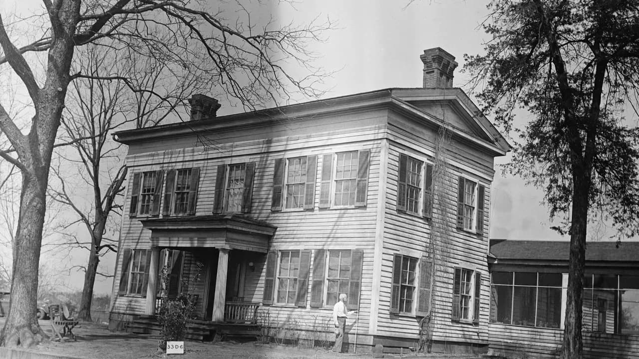
The houses from these years are the reason the town is known to architects. The house at the top of this article was built in 1839, according to its 1936 state marker, by Isaac Campbell; architectural historians say Campbell built it as a wedding gift for his wife. The Handbook credits the design to Augustus Phelps, a New England architect, while the 1936 HABS survey said it was erected by local builder Sidney A. Sweet. Matthew Cartwright, the merchant and land dealer who by his death in 1870 owned a million acres of Texas land, bought it in 1847 according to the marker, or in 1849 according to the Handbook, which says he bought it from his sister-in-law, Mrs. Isaac Campbell. After Campbell died in 1843, the architectural survey says, the house was sold to Wesleyan College before Cartwright bought it. The Handbook says it was still in the Cartwright family in 1991. [7] [8] [6]
The post office came late. It opened in March 1847 as Kendricks, became Ayish Bayou that September, and was named San Augustine in March 1848. [1]
1850–1868: cotton, slavery and Reconstruction
The prosperity of the 1840s and 1850s rested in part on enslaved labor. In 1850 the county had 3,648 people, 1,561 of them enslaved. By 1860 it had 4,094, including 1,717 enslaved people held by 144 slaveholders, only eight of whom held more than forty. Each precinct had a patrol appointed to police enslaved people. Cotton went by ox wagon to Shreveport, Natchitoches and New Orleans. In town, a two-story brick courthouse went up in 1854, and by 1860 San Augustine was a cotton shipping center. [2] [1]
The county’s delegate to the 1861 Secession Convention, Calloway Deen Sr., argued against leaving the Union. Voters endorsed secession anyway. San Augustine sent three companies in the summer of 1861, and in 1862 a battalion of the Third Texas Brigade was posted in town. [2] [1]
Reconstruction here was violent, and the county entry does not soften it. In 1867, when Black men began registering to vote, Harry Garrett, a schoolteacher and former slave, held meetings and organized a Black militia company. After a white farmer, Jesse Burnett, was killed by a Black hired hand, white residents formed what the Handbook calls a Ku Klux Klan-like organization that used flogging to drive most of the Black activists out of the county. In 1868 a mob drove the Black voter registrar out of the county seat and harassed the local Freedmen’s Bureau agent. After the turn of the century, measures to disfranchise Black and some white voters cut the county’s electorate from 1,353 in 1900 to 528 in 1908. [2]
1890–1903: fire, then the railroad
The 1870s were hard. Houston, Dallas and the West Texas plains drew the new settlers, and San Augustine was no longer the gateway into Texas. By 1884 the town had about 600 people, cotton gins, a gristmill and two small sawmills, but the big places that had once served travelers stood closed. In 1890 a fire destroyed much of the town. It rebuilt, the old courthouse was torn down and replaced, and the Handbook counts about 700 residents and five churches in the years after. [1] [2]
The Handbook’s census table lists 744 people in 1890, then 261 in 1900, then 1,204 in 1910. The entry gives no explanation for the 1900 figure, and we do not offer one. [1]
Then the tracks came. In 1901 the Gulf, Beaumont and Great Northern Railway reached San Augustine, and in 1903 the Santa Fe system bought the line to haul lumber. The Handbook says the railroad made large sawmill operations possible here for the first time. By 1910 the town had 1,200 people, and by 1914, 1,300, with a telephone exchange, a bank and two weekly papers. [1]
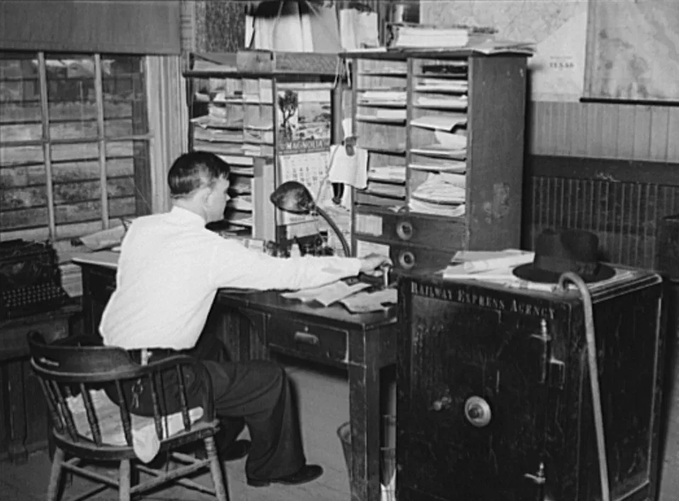
The Railway Express Agency office in the San Augustine station, April 1939. The Library of Congress caption reads “Railway express agency office in station. San Augustine, Texas.” It does not name the clerk. Russell Lee, Farm Security Administration, Library of Congress (LC-USF34-032987-D). Public domain.
1927 to today: a stone courthouse and the medallion homes
In 1927 the courthouse was replaced again, this time with a two-story stone building, and the town had city water, lights and sewer, an ice plant and natural gas. The Depression undid much of that. The lumber companies had cut the best timber and left, twenty-seven businesses closed, and farmers lost their markets. The Work Projects Administration, the Civilian Conservation Corps and federal loans helped. By World War II the Deep East Texas Electric Cooperative, serving four counties, had its headquarters here, and the town had about eighty businesses, many of them around the square. [1]
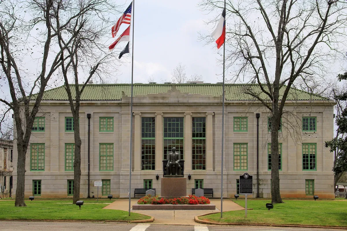
The San Augustine County Courthouse in April 2015. This is the stone courthouse built in 1927, the third the Handbook mentions. Larry D. Moore, CC BY 4.0, via Wikimedia Commons.
The town reached 2,584 people in 1960 and 2,930 in the 1980 census, its high mark in the Handbook’s table. It has been smaller since: 2,337 in 1990, 2,475 in 2000, 2,108 in 2010, and 1,920 in the 2020 Census. The Handbook lists a 2021 estimate of 1,854. [1] [12]
What draws visitors is the old part. The annual Tour of Medallion Homes and Historic Places takes in houses the Handbook names for Stephen W. Blount, Matthew Cartwright, George L. Crocket, Ezekiel W. Cullen, Almanzon Huston and Philip A. Sublett. In 1934 and 1936 the Historic American Buildings Survey photographed several of them, which is why the picture at the top of this article exists. And the City of San Augustine bought the mission site in the early 1990s, opened a museum, and in 2016 asked the state to take it over. [1] [13] [4]
The complete story of San Augustine
It is the story of the Ais, who lived on this bayou for centuries and would not move into the mission built for them, and of Spanish friars who stayed fifty years anyway.
It is the story of mustangers and Neutral Ground settlers, of fifteen men who paid ninety dollars for a town site and drew it as a grid, and of a town that sent Sam Houston to a convention, emptied in the Runaway Scrape, and came back.
It is the story of churches founded in the first years of open Protestant worship, of three colleges that could not survive one another, of the people held in slavery here, and of the freedmen who tried to vote in 1867 and were flogged and driven out for it.
And it is the story of a fire, a railroad, a lumber boom that left, and a square that is still there. The town was here before the Republic was.
Questions people ask
When was San Augustine founded? The town site was bought in January 1833 and surveyed that year; the municipality was established under Mexican law in 1834 and incorporated by the Republic of Texas on June 5, 1837. The Spanish mission nearby dates to 1717, or 1716 by the 1936 marker. [1] [5]
Who is San Augustine named for? The Handbook says Mexican officials chose the name in 1834, supposedly to honor St. Augustine of Hippo. It does not cite a document for that. [1]
Can you visit Mission Dolores? Yes. Mission Dolores State Historic Site, run by the Texas Historical Commission at 701 South Broadway, has a museum and walking trails. No original buildings survive above ground. [4] [5]
Sources
Vista K. McCroskey, “San Augustine, TX (San Augustine County),” Handbook of Texas Online, Texas State Historical Association, revised February 12, 2019. tshaonline.org/handbook/entries/san-augustine-tx-san-augustine-county. The entry’s bibliography cites George L. Crocket, Two Centuries in East Texas (1932); Alexander Horton, “Life of A. Horton and Early Settlement of San Augustine County” (1911); and William Seale, San Augustine in the Texas Republic (1969).
Vista K. McCroskey, “San Augustine County,” Handbook of Texas Online, revised February 10, 2021. tshaonline.org/handbook/entries/san-augustine-county.
James E. Corbin, “Nuestra Señora de los Dolores de los Ais Mission,” Handbook of Texas Online, revised August 11, 2020. tshaonline.org/handbook/entries/nuestra-senora-de-los-dolores-de-los-ais-mission. Its bibliography includes Corbin et al., Mission Dolores de los Ais (Stephen F. Austin State University, 1980).
Texas Historical Commission, “Mission Dolores History,” Mission Dolores State Historic Site. thc.texas.gov.
Texas Historical Commission, Atlas, “Mission Nuestra Senora de los Dolores de los Ais,” marker 7627, 1936 Texas Centennial marker, 701 S. Broadway St. atlas.thc.texas.gov/Details/5405007627.
Sandra Kardell Calpakis, “Cartwright, Matthew,” Handbook of Texas Online, revised January 25, 2023. tshaonline.org/handbook/entries/cartwright-matthew.
Texas Historical Commission, Atlas, “Home of Matthew Cartwright,” marker 16087, 1936 Texas Centennial marker, 503 E. Main St. atlas.thc.texas.gov/Details/5507016087.
“Matthew Cartwright House (Isaac and Elizabeth Campbell House),” SAH Archipedia, Society of Architectural Historians. sah-archipedia.org/buildings/TX-02-LC53.
Nancy Beck Young, “University of San Augustine,” Handbook of Texas Online, revised December 1, 1995. tshaonline.org/handbook/entries/university-of-san-augustine.
John C. English, “Wesleyan College,” Handbook of Texas Online, revised February 1, 1996. tshaonline.org/handbook/entries/wesleyan-college.
Christopher Long, “Cullen, Ezekiel Wimberly,” Handbook of Texas Online, revised April 7, 2018. tshaonline.org/handbook/entries/cullen-ezekiel-wimberly.
U.S. Census Bureau, 2020 Census, San Augustine city, Texas, population 1,920. data.census.gov.
C. C. Bulger, “General view from southeast, Matthew Cartwright House,” Historic American Buildings Survey, March 13, 1934, HABS TEX,203-SAUG,2-1, Library of Congress. loc.gov/pictures/item/tx0251.
Russell Lee, “Railway express agency office in station. San Augustine, Texas,” April 1939, Farm Security Administration/Office of War Information collection, Library of Congress, LC-USF34-032987-D. loc.gov/pictures/item/fsa2000014190/PP (via Wikimedia Commons).
Larry D. Moore, “San Augustine County Courthouse,” photograph, April 3, 2015, CC BY 4.0. commons.wikimedia.org.