The History of Albany, Texas
Albany, Texas (ZIP 76430) was laid out in 1874 as the seat of Shackelford County, fifteen miles from the lawless town below Fort Griffin. In 1878 a former sheriff was shot by masked men in its jail; the sources still name no one.
Editor’s note. This is the twenty-seventh installment of “Texas Towns: The Stories Behind the Map.” The last one went to Fredericksburg, in the Hill Country, where German settlers made a treaty with the Comanches in 1847. This one goes north and west, onto the Rolling Plains, to a county seat that grew up in the shadow of an army post. The Handbook of Texas says Fort Griffin, on the Clear Fork of the Brazos, was the nucleus of a border-defense line that ran from Fort Richardson at Jacksboro to the Big Bend country. Albany, fifteen miles south of the fort, is the town that outlasted it.
Albany, Texas, is the county seat of Shackelford County and sits close to the center of the county, about thirty-five miles northeast of Abilene. U.S. Highway 283 runs through it north to south, on its way from Vernon and Seymour toward Baird. U.S. Highway 180 crosses it on the way from Breckenridge to Anson, and State Highway 6 passes through between Stamford and Cisco. The tracks of the Texas Central Railroad reached Albany in the early 1880s, and for nineteen years the town was the end of the line. The mailing ZIP is 76430. [1] [2] [29] [30] [31] [24]
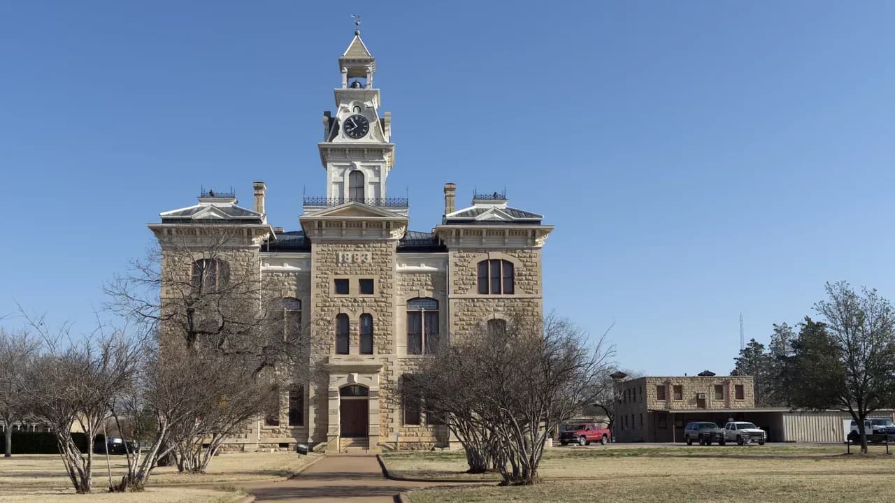
The town is small; the Census Bureau’s estimate for July 1, 2025, is 1,905 people. A driver coming into town today sees a limestone courthouse with a clock tower in the middle of a square, an old two-story stone jail that is now an art museum, and signs for an outdoor show called the Fort Griffin Fandangle. All three have a documented history. Some of it is rough, and this article tells it as the sources do. [28] [19] [8] [14]
Before 1867: Comanches, a salt works and family forts
The Handbook’s county entry says Athabascan Apaches once lived on the game in this country and were driven out by the Comanches, who held the region until Anglo settlers began arriving in the middle and late nineteenth century. A Spanish expedition under José Mares may have touched the southwest corner of the county in 1788, but the Handbook counts Capt. Randolph B. Marcy of the U.S. Army as the first real explorer of the area. [2]
The first white settler was probably Jesse Stem, an Indian agent who started a farm on the Clear Fork in 1852 and raised a crop of corn and oats the next year, which he sold at Fort Belknap. Two years after Stem arrived, Marcy recommended a fort on the Clear Fork, and the line of posts that followed, including Camp Cooper just to the north in Throckmorton County, brought the first real wave of settlers. In 1861 ranchers C. C. Cooper and John C. Lynch and their hands and families built a fortified settlement they called Fort Hubbard. [2]
During the Civil War, the families who stayed on this frontier “forted up” in stockades. A 1963 state marker names several in Shackelford County, among them the Lynch and Green ranches and Mugginsville. W. H. Ledbetter, later the county’s first judge, made salt by boiling down the water of the Salt Prong of Hubbard Creek. The county entry says he began two years after Fort Hubbard was built, which would be 1863; the state’s markers for his salt works and his picket house give 1862. The salt marker says the works supplied Confederate troops and ranches across a wide region and kept producing until 1880. [2] [26]
1867–1874: the fort on the hill and the Flat below
Lt. Col. Samuel D. Sturgis chose the site on the Clear Fork in northeastern Shackelford County and led four companies of the Sixth U.S. Cavalry there on July 31, 1867. The post was first called Camp Wilson and was soon renamed for Gen. Charles Griffin, who commanded the Military District of Texas. Stone buildings were planned, but the Handbook says the soldiers’ quarters, stables and even the hospital were always temporary, some of them only canvas-covered shelters. The older posts at Belknap, Phantom Hill and Chadbourne became subposts of Griffin. [3]
The Tonkawas, who had been allies of Anglo Texans against the Comanches, came back to Texas after the Civil War and, the Handbook says, most of them settled near Fort Griffin, where they served as army scouts until the Indian wars ended. They had already paid a heavy price for that alliance: in the 1850s Texans angry over raids attacked the Brazos reservations, the Tonkawas were removed to Indian Territory in 1859, and after federal troops withdrew in 1861 other tribes attacked them and killed about half of the 300 Tonkawas. [16]
Below the hill grew a civilian town called the Flat, or Hidetown. It was a market for buffalo hunters, especially in the hide seasons of 1874 through 1877, and a watering hole for soldiers and trail hands. The Handbook’s entry on the town names Lottie Deno, Doc Holliday, Wyatt Earp, Pat Garrett and John Wesley Hardin among the people who passed through. By 1874 the lawlessness was so bad that the commander of the fort put the town under government control and forced some residents to leave. At its height Fort Griffin had about 1,000 permanent residents and perhaps twice that many passing through. [4] [2]
1874–1877: a county, and a town named for Georgia
Until then, jury duty and legal business meant a long, hazardous trip to the county court in Jack County, at Jacksboro. In 1874 residents petitioned the Jack County court for permission to organize a county of their own. It was named for Dr. Jack Shackelford, a hero of the Texas Revolution; a 1936 Centennial marker identifies him as captain of the Red Rovers, the Alabama company in Fannin’s command, and one of the few men spared at Goliad. Fort Griffin served as the temporary county seat. The county entry gives October 12, 1874, as the date Fort Griffin took that role; the state’s markers say the county was organized on September 12, 1874. We print both dates. [2] [26]
On November 8, 1874, the county’s founders called an election to choose a permanent seat, and the site chosen lay near the center of the county, fifteen miles south of the Flat. The townsite was donated by Henry C. Jacobs, the first sheriff; a 1975 state marker says it covered forty-three acres. William R. Cruger, who had come to the county that year and helped organize it, named the town for his birthplace, Albany, Georgia. The 1975 marker calls him the county clerk. [1] [2] [5] [18]
Town lots went on sale August 2, 1875, and within a few months T. E. Jackson had built a general store. A wooden picket courthouse went up. The post office opened August 1, 1876, and by late 1877 the town had sixteen buildings: homes, hotels, saloons and a blacksmith shop. Jacobs built the first permanent house in Albany, of local stone, in 1875; a 1974 marker says he platted the town and donated the sites for the courthouse and the Presbyterian church. [1] [18] [26]
Faith came to the county before the town did. The First United Methodist Church of Albany traces itself to 1873, when the Rev. Levi Collins came from the Weatherford circuit at the request of rancher J. C. Lynch and organized a congregation at Lynch’s ranch house, eight miles east of the future town site. Its 1973 marker calls it the first church of any denomination in Shackelford County. Its charter members were Peter, Mollie and S. A. Gunsolus, Mr. and Mrs. Lynch, and Elizabeth and Malinda McNutt. [21]
1876–1878: the sheriff who was shot in jail
The hardest chapter in Albany’s early years belongs to John M. Larn. The Handbook says he killed a rancher in Colorado before he drifted to Fort Griffin about 1869. On a cattle drive in 1871 he was alleged to have killed two Mexicans and a shepherd, and in 1873 he and a posse that included thirteen soldiers from the fort ambushed and killed the members of a cattle outfit he had a warrant against for rustling. In 1874 he joined a Griffin vigilance committee known as the Tin Hat Brigade, and, in the Handbook’s words, “many a horse thief was found hanging from a tree near the river.” The standing he gained helped elect him sheriff in 1876. Cruger became his deputy. [6] [5]
Larn resigned as sheriff in March 1877, and Cruger was appointed to succeed him on April 20, 1877; early that year Cruger had been wounded in a saloon gunfight at Fort Griffin in which three men were killed. Larn and his associate John Selman were then made deputy hide inspectors for the county and took a contract to supply beef to the fort and to the Tonkawas. Ranchers complained that they were losing cattle while Larn’s herd never shrank, and settlers reported that a band said to be led by Larn and Selman was shooting horses on the range and firing into houses at night. In February 1878 a posse found six hides that were not his in the river behind his house. He was arrested and released. [5] [6]
On June 23, 1878, Sheriff Cruger arrested Larn in his barn on a warrant from the Albany court and took him to the Albany jail. There he was shot to death by a group of masked men. The Larn entry puts the killing in the early morning hours of June 24; the Cruger entry says the night of the arrest, June 23, and says the killers were presumably members of the Fort Griffin vigilance committee. The Selman entry says the vigilantes locked Larn in his own jail and shot him. Nobody in these sources is named as one of the killers, and the Cruger entry calls it the last vigilante killing in the county. The Handbook does not say which building Larn was held in. Shackelford County’s stone jail, begun in 1877, was not finished until August 1878, about two months after his death. [6] [5] [7] [8]
Selman fled the state. Texas Rangers captured him in 1880 at Fort Davis, in Jeff Davis County, the town this series visited in its twentieth installment, and brought him back to Shackelford County for trial. He escaped. The Old Jail entry says he escaped from the stone jail itself. In 1895, in El Paso, he killed John Wesley Hardin. Cruger resigned as sheriff on July 20, 1880, with a resolution of thanks from the commissioners court. He was killed two years later while serving as a city marshal in Tennessee. [7] [8] [5]
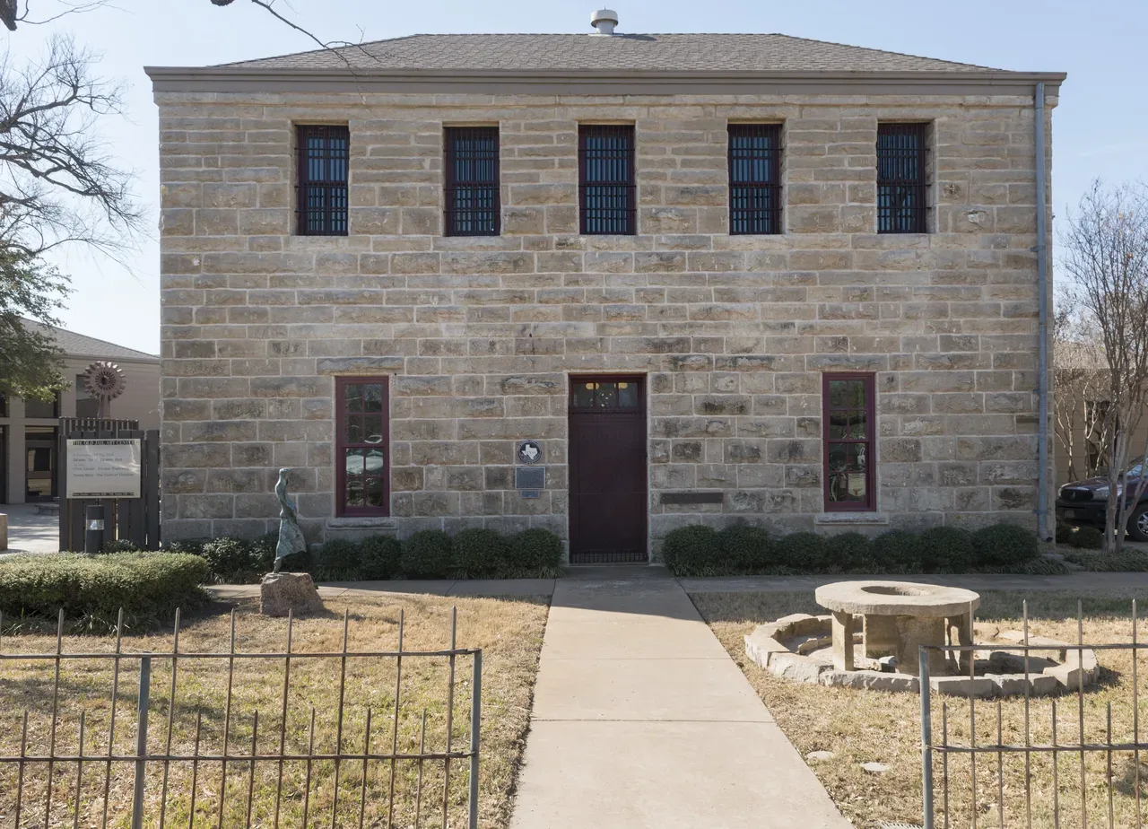
Shackelford County’s first permanent jail, on South Second Street in Albany, photographed March 25, 2014, when it was the Old Jail Art Center. The Handbook says construction began in 1877 and was finished in August 1878, at a cost of $9,000; prisoners were held upstairs, behind windows that originally had iron bars and no glass, and the jailer’s family lived in the two rooms below. The photograph shows the building as restored and expanded for the museum; it is not how the jail looked in 1878. Carol M. Highsmith, Lyda Hill Texas Collection of Photographs in Carol M. Highsmith’s America Project, Library of Congress Prints and Photographs Division (LCCN 2014631738), public domain.
1875–1885: the cattle trail and the end of track
Herds bound for Dodge City on the Western Trail began passing through about 1875, and Albany became a supply point. The Handbook’s trail entry says the trail fanned into three branches at Pecan Bayou in Callahan County, and all three rejoined the main trunk at Albany; from there it crossed the Clear Fork near Fort Griffin. In 1883 Jack Potter blazed the Potter-Bacon Trail northwest from Albany toward the Llano Estacado and the Colorado pastures. A 1964 marker on the courthouse square dates the trail from 1875 to 1890. [1] [10] [26]
The railroad decided which of the county’s towns would live. The Texas Central was chartered in 1879 as a feeder to the Houston and Texas Central, and between 1879 and 1882 it built 177 miles from Ross, near Waco, to Albany. The Handbook’s Albany entry says the line arrived in December 1881, the county entry says it was completed in 1882, and the state’s railroad marker says the track reached Albany by 1881. The same marker says Albany’s citizens raised $50,000 to win the line away from Fort Griffin, and that money troubles left Albany as the end of the line for nineteen years. Albany shipped cattle, buffalo bones and building stone. [9] [1] [2] [24] [26]
The army closed Fort Griffin on May 31, 1881, and marched its last company south to Fort Clark. With the buffalo gone, the soldiers leaving and the tracks running through Albany, the Flat collapsed. The Handbook says virtually nothing is left of it. In 1884 the surviving Tonkawas and some Lipan Apaches were moved to a reservation in Indian Territory; the Handbook counts ninety-two Tonkawas that year, and fifty-one by 1937. [3] [4] [16] [2]
Albany kept building. Voters authorized the first public school system on July 20, 1883, and the Albany News replaced the Albany Star that year. The 1975 marker says a church building stood by 1882, and an opera hall opened in 1883. The courthouse went up in 1883–84 from plans by J. E. Flanders of Dallas, with Edgar Rye of Albany as superintendent. The marker says kilted Scottish masons laid walls of stone quarried a few miles southwest of town, on foundations two feet deep in caliche. It was budgeted at $27,000 and cost $49,433.75, and the clock tower was added at the public’s request. The Handbook’s town entry says it was built in 1883 and the county entry says it was finished in 1884; the stone over the door reads 1883. [1] [18] [19] [2] [33]
The figures for Albany’s early population do not agree, and they measure different things. The Texas Almanac table on the Handbook’s town page gives 129 people in 1880 and 857 in 1890. The Sanborn Map Company, which drew Albany for fire insurers in February 1885, stamped “Population 1600” on its map. That number is the mapmaker’s, not a census count, and we print it as it appears. [1] [32]
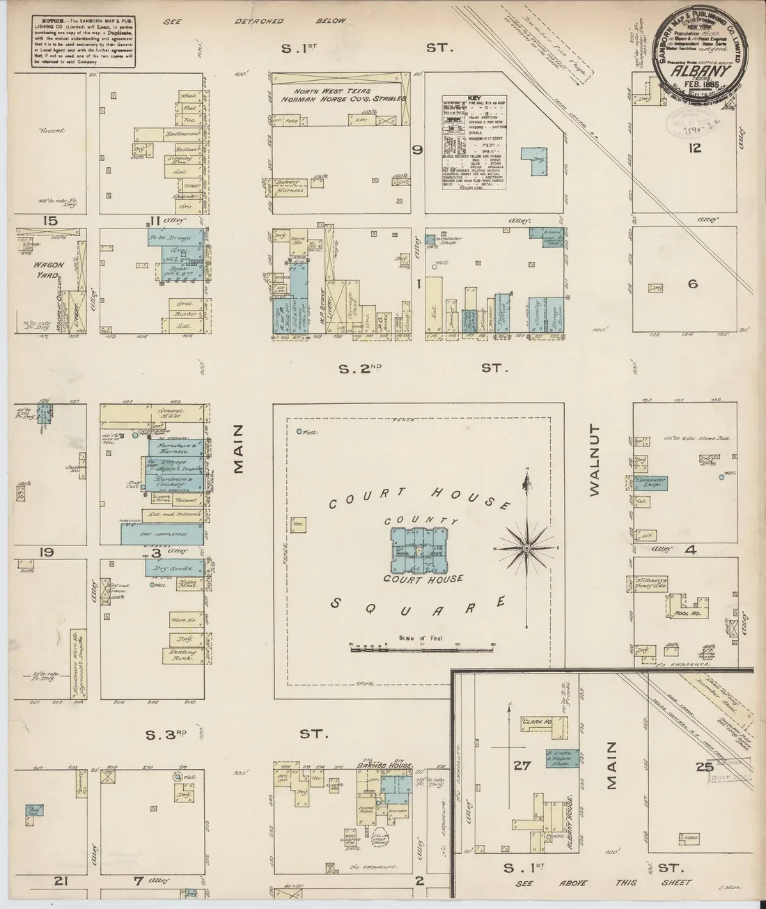
Sheet 1 of the Sanborn Map & Publishing Co. fire insurance map of Albany, dated February 1885. It shows the courthouse square between Main and Walnut streets with the courthouse at its center, the business blocks around it, and the Texas Central Railroad crossing the upper right corner. Blue marks stone buildings and yellow marks frame ones. The stamp gives the population as 1,600 and rates the water facilities “not good.” This is a map drawn for insurers, not a photograph. Sanborn Map & Publishing Co., 1885, Library of Congress Geography and Map Division, via Wikimedia Commons, public domain.
1884–1888: a parson, a drought and Clara Barton
In 1884 the Rev. John Brown, a Scottish immigrant who had studied theology in New York, became minister of the Albany Presbyterian Church. A 2006 state marker says he had married Mary Jane Matthews Larn, the widow of the sheriff killed in the Albany jail, near Fort Griffin. He took the pulpit just as a long drought was ruining farmers and ranchers across West Texas. [23] [6]
Local leaders chose Brown to go east and ask for help buying seed wheat for small farmers. He left in August 1886. The marker says newspapers followed his trip, and that Texas editors and land and railroad promoters were angry, fearing the publicity would hurt the state. Several railroad cars of seed wheat were sent anyway, along with several thousand dollars from eastern Presbyterian churches. Brown also appealed to Clara Barton and the American Red Cross, arguing that drought relief was as fitting as aid after a hurricane. The Red Cross shipped clothing, household goods and tools to Albany, and in January 1887 Barton herself toured Shackelford, Stephens, Young and Callahan counties. Back in Texas, Brown spoke to the legislature at the request of twenty-one counties, and a relief bill passed and was signed by Gov. L. S. (Sul) Ross. Brown moved to Massachusetts in 1887. [23]
The Methodists, meanwhile, had put up a small frame church on Schoolhouse Hill by 1882. A tornado destroyed it in 1888, and the congregation built a second church on the same site in 1889. That building was moved to Main Street in 1909, sold to the new Trinity Episcopal mission in 1913 and moved again in 1954, to the old academy grounds. Its 1962 marker calls it the oldest church building in Albany. [21] [26]
1898–1925: an academy, a ranch and the Home of the Hereford
The ranching families tied to Fort Griffin became Albany’s leading families. John Alexander Matthews, whose family had settled near the fort after the Civil War, married Sallie Ann Reynolds on Christmas Day, 1876. From 1880 to 1885 he was in partnership with her brothers George T. and William D. Reynolds, and from his share he built the J. A. Matthews Ranch Company, headquartered on the Lambshead Ranch north of town. It was named for Thomas Lambshead, an early settler from Devon, England. Matthews was county judge in 1895–96 and led a campaign to dip cattle against ticks from 1915 to 1917. [12] [13]
In February 1898 the Reynolds and Matthews families chartered the Reynolds Presbyterian Academy, at the urging of the Presbyterian pastor, French McAfee, and named it for Barber Watkins Reynolds. Classes met at first in the church and a vacant store; a turreted brick building on a hill west of town opened January 10, 1899. The Abilene Presbytery took it over in 1909 and raised it to a college. The Handbook says the college was abandoned by 1914, that the dormitory became the Reynolds Presbyterian Home orphanage beginning in 1913, and that the buildings were razed in 1927. The 1974 marker at the site says the college closed about 1915, the orphanage used the plant from 1916 to 1923, and the building was razed in 1928. The two accounts do not match, and we print both. [11] [22]
The Presbyterians built a church that same year; the medallion on Matthews Memorial Presbyterian Church says the building was constructed in 1898 and remodeled in 1954 under the leadership of Watt Matthews. The Texas Central began building again in 1900, extending its line from Albany to Stamford, so Albany was no longer the end of track. Cattle and sheep still ran the local economy. Since 1920, the Handbook says, the town slogan has been “Albany, the Home of the Hereford.” [26] [9] [24] [1]
1926–1968: the Cook field and the Fandangle
Natural gas came first. The county entry says oil was discovered in Shackelford County in 1910, and a state marker in Moran says the Cottle No. 1 found gas there on November 9, 1910, and that Albany was supplied with natural gas by 1913. The big change came in 1926 with the Cook oilfield. The marker for the Cook Ranch field says the widow of rancher W. I. Cook leased the open acreage in 1925 to Roeser & Pendleton, and the firm’s second well, in 1926, struck oil at 1,241 feet and flowed 1,000 barrels a day. Low-pressure gas injection began on the ranch in 1927. Matilda Cook used the oil money to found the W. I. Cook Memorial Hospital in Fort Worth in 1929. The county’s population peaked at 6,695 in 1930, and the Almanac table gives Albany 2,422 that year. [2] [26] [25] [1]
Robert E. Nail Jr. grew up in Albany. His uncle owned the Cook Ranch. Nail studied at the Lawrenceville School, where Thornton Wilder encouraged him, and at Princeton, then came home during the Depression. In March 1938 he became head of drama at Albany High School, and that spring the senior class staged his Dr. Shackelford’s Paradise, a pageant of county history with a cast of 200, on the football field. It went over so well that it was done again that summer with adults in the cast and a new name, the Fort Griffin Fandangle. The Handbook’s Albany entry says the Fandangle originated in 1938; its Fandangle entry traces it to a December 1937 Lions Club Cowboy Ball that Nail directed with music teacher Alice Reynolds to raise money for the needy at Christmas. [15] [14] [1]
The original script drew on Interwoven, Sallie Reynolds Matthews’s 1936 memoir of frontier life. Nail set three rules: anyone with ties to Shackelford County could be in the show, it would be advertised only by word of mouth, and there would be no profanity. The performers have never been paid. The show stopped during World War II, was revived in 1947, and was halted again from 1958 to 1964. In 1965 the Prairie Theatre was built just outside town. The Fandangle entry says the land was leased from the John Alexander Matthews estate for a dollar a year; Nail’s biography says Watt Matthews and other family members donated the site, the old railroad shipping pens northwest of town. We print both. In 1979 the legislature named the Fandangle one of four official state plays of Texas. [17] [14] [15]
In 1939 the Ministerial Association of Albany, led by the First Baptist Church, asked Nail to write and direct a Christmas pageant. The Albany Nativity, as it is called, has been given in alternate years, free to the public, in the restored Aztec Theater. Nail died of a heart attack at his home in Albany on November 11, 1968, fifty-eight years ago today, and was buried in the Albany cemetery. [15]
1929–2025: the old jail, the end of the line and a modern count
The county built a new jail in 1929. In June 1940 Nail bought the old one from the county for $375 and used it as a studio and archive until his death. In 1977 the Old Jail Foundation was organized to restore it, and on December 19, 1980, it opened as a museum. The Handbook’s Albany entry lists Chinese tomb figures, pre-Columbian art and works by Henry Moore, Picasso and Modigliani in its collection. Masons’ initials are still cut into many of the limestone blocks, the state marker says, as their claims for payment. [8] [20] [1] [34]
The Katy, which had leased the Texas Central since 1914, got permission to abandon the line east of Stamford in 1967, and most of the track through this country was taken up. Fort Griffin passed from Texas Parks and Wildlife to the Texas Historical Commission on January 1, 2008, as the 506-acre Fort Griffin State Historic Site. The courthouse was restored through the commission’s courthouse preservation program and rededicated June 30, 2001; the commission calls it Second Empire and notes how plain it is, with an unusual proportion of window to wall. [9] [4] [27]
The modern counts do not line up neatly. The Handbook’s town entry gives 1,921 residents in 2000. Its county entry gives Albany 2,038 in 2014. The Almanac table on the town page lists 2,034 for 2010, 1,854 for 2020 and 1,927 for 2021. The Census Bureau’s estimates program starts from a 2020 base of 1,857 for the city and estimated 1,905 residents on July 1, 2025. Counts and estimates are different measures, and we print them as published. [1] [2] [28]
The complete story of Albany
It is the story of a county seat laid out in 1874 near the center of a new county, fifteen miles from a town so lawless the army had put it under government control. It is the story of a sheriff who rode with vigilantes and was shot by masked men in the Albany jail, and of the parson who later married his widow and went east to beg seed wheat for drought-stricken farmers. It is the story of the Tonkawas who scouted for Fort Griffin and were moved to Indian Territory three years after it closed. It is the story of $50,000 raised for a railroad, a limestone courthouse with 1883 over the door, a Methodist church organized in a ranch house, a Presbyterian academy on the hill, and an oil field that came in at 1,241 feet. It is the story of a playwright who came home and put the whole county on a stage, with no paid actors and no profanity. The fort on the hill is a ruin. Albany is still the county seat.
Questions people ask
How did Albany, Texas, get its name? William R. Cruger, who helped organize Shackelford County in 1874, named the county seat for his birthplace, Albany, Georgia. [1] [5]
Why isn’t Fort Griffin the county seat? Fort Griffin was the temporary seat in 1874, but an election called on November 8, 1874, chose a new site near the center of the county, which became Albany. When the army left the fort in 1881 and the Texas Central built to Albany instead, the town of Fort Griffin declined fast. [2] [4] [24]
Who killed John Larn? The record does not name anyone. The Handbook says he was shot in the Albany jail by masked men in June 1878; the entry on Sheriff William Cruger says the killers were presumably members of the Fort Griffin vigilance committee. [6] [5]
What is the Fort Griffin Fandangle? An outdoor musical about the history of the Clear Fork country, produced in Albany in June, which Robert E. Nail Jr. started in 1938. It has had interruptions, including the war years and 1958–64. The legislature named it an official state play of Texas in 1979. [14] [15]
What is Albany’s ZIP code? 76430. Albany is the county seat of Shackelford County, on U.S. 283, U.S. 180 and State Highway 6. [29] [30] [31]
Sources
Marilynne Howsley Jacobs, “Albany, TX,” Handbook of Texas Online, Texas State Historical Association, revised September 20, 2023. tshaonline.org/handbook/entries/albany-tx. The entry’s bibliography includes Don Hampton Biggers, Shackelford County Sketches (1908; rpt. Clear Fork Press, 1974) and Shackelford County (Shackelford County Historical Survey Committee, 1974). The page also carries the Texas Almanac’s population table.
Frank Beesley, “Shackelford County,” Handbook of Texas Online, revised February 3, 2021. tshaonline.org/handbook/entries/shackelford-county. Its bibliography includes Ben O. Grant, The Early History of Shackelford County (M.A. thesis, Hardin-Simmons University, 1936).
Vernon Lynch, “Fort Griffin,” Handbook of Texas Online, revised July 19, 2016. tshaonline.org/handbook/entries/fort-griffin. Its bibliography includes Carl Coke Rister, Fort Griffin on the Texas Frontier (University of Oklahoma Press, 1956).
Lawrence Clayton, “Fort Griffin, TX,” Handbook of Texas Online, revised December 2, 2022. tshaonline.org/handbook/entries/fort-griffin-tx.
J. R. Webb, “Cruger, William R.,” Handbook of Texas Online, revised September 26, 2019. tshaonline.org/handbook/entries/cruger-william-r.
Julia Putnam, “Larn, John M.,” Handbook of Texas Online, published March 1, 1995. tshaonline.org/handbook/entries/larn-john-m. Its bibliography includes Frances Mayhugh Holden, Lambshead Before Interwoven (Texas A&M University Press, 1982) and Leon C. Metz, John Selman (1966; 2d ed., University of Oklahoma Press, 1980).
Leon C. Metz, “Selman, John Henry,” Handbook of Texas Online, revised February 19, 2019. tshaonline.org/handbook/entries/selman-john-henry.
Joan Farmer, “Old Jail Art Center,” Handbook of Texas Online, revised May 30, 2025. tshaonline.org/handbook/entries/old-jail-art-center.
Nancy Beck Young, “Texas Central Railroad,” Handbook of Texas Online, revised May 14, 2019. tshaonline.org/handbook/entries/texas-central-railroad.
Jimmy M. Skaggs, revised by Gary Kraisinger and Margaret Kraisinger, “Western Trail,” Handbook of Texas Online, revised July 1, 2026. tshaonline.org/handbook/entries/western-trail.
Hugh Allen Anderson, “Reynolds Presbyterian College,” Handbook of Texas Online, revised May 1, 1995. tshaonline.org/handbook/entries/reynolds-presbyterian-college. Its bibliography includes Ruby McGill Dodge, Reynolds Presbyterian Academy and College (1960).
Robert Nail, “Matthews, John Alexander,” Handbook of Texas Online, revised January 24, 2020. tshaonline.org/handbook/entries/matthews-john-alexander.
Frances Mayhugh Holden, “Lambshead Ranch,” Handbook of Texas Online, published March 1, 1995. tshaonline.org/handbook/entries/lambshead-ranch.
Lawrence Clayton, “Fort Griffin Fandangle,” Handbook of Texas Online, revised October 7, 2015. tshaonline.org/handbook/entries/fort-griffin-fandangle.
Shirley Caldwell, “Nail, Robert Edward, Jr.,” Handbook of Texas Online, revised August 6, 2015. tshaonline.org/handbook/entries/nail-robert-edward-jr. Its bibliography includes Robert E. Nail, The Fandangle: A People’s Theater (Fort Griffin Fandangle Association, 1970).
Jeffrey D. Carlisle, “Tonkawa Indians,” Handbook of Texas Online. tshaonline.org/handbook/entries/tonkawa-indians.
Robert Nail, “Matthews, Sallie Ann Reynolds,” Handbook of Texas Online, revised April 1, 1995. tshaonline.org/handbook/entries/matthews-sallie-ann-reynolds. See Sallie Reynolds Matthews, Interwoven: A Pioneer Chronicle (1936; 4th ed., Texas A&M University Press, 1982).
Texas Historical Commission, Atlas, “City of Albany” (marker 879, 1975). atlas.thc.texas.gov/Details/5417000879.
Texas Historical Commission, Atlas, “Shackelford County Courthouse” (marker 4649, Recorded Texas Historic Landmark, 1962). atlas.thc.texas.gov/Details/5417004649.
Texas Historical Commission, Atlas, “Shackelford County’s First Permanent Jail” (marker 4650, Recorded Texas Historic Landmark, 1962). atlas.thc.texas.gov/Details/5417004650.
Texas Historical Commission, Atlas, “First United Methodist Church of Albany” (marker 1879, 1973). atlas.thc.texas.gov/Details/5417001879.
Texas Historical Commission, Atlas, “Site of Reynolds Presbyterian Academy” (marker 4879, 1974). atlas.thc.texas.gov/Details/5417004879.
Texas Historical Commission, Atlas, “The Rev. John Brown, Clara Barton and the 1886–1887 Drought Relief” (marker 13673, 2006). atlas.thc.texas.gov/Details/5507013673.
Texas Historical Commission, Atlas, “Texas Central Railway Company” (marker 5253, Webb Park, 112 Main Street). atlas.thc.texas.gov/Details/5417005253. The Atlas record carries no inscription; the marker text is quoted from the transcription in source 26.
Texas Historical Commission, Atlas, “Cook Ranch Oil Field” (marker 1052, 1976). atlas.thc.texas.gov/Details/5417001052.
Duston Brooks, comp., “Shackelford County Historical Markers,” Shackelford County TXGenWeb (marker transcriptions, including Family Forts, Ledbetter Salt Works, Ledbetter Picket House, H. C. Jacobs House, Shackelford County [1936 and 1976], Texas Cattle Trail, Texas Central Railway Company, Trinity Episcopal Church, Matthews Memorial Presbyterian Church and Cottle No. 1). txgenwebcounties.com/shackelford/markers.htm.
Texas Historical Commission, “Shackelford County Courthouse,” Texas Historic Courthouse Preservation Program. thc.texas.gov, restored historic courthouses: Shackelford County.
U.S. Census Bureau, Population Estimates Program, “City and Town Population Totals: 2020–2025” (sub-est2025.csv), Albany city, Texas: April 1, 2020, estimates base 1,857; July 1, 2025, estimate 1,905. census.gov sub-est2025.csv.
Texas Department of Transportation, Highway Designation File, U.S. Highway 283. dot.state.tx.us/tpp/hwy/us/us0283.htm.
Texas Department of Transportation, Highway Designation File, U.S. Highway 180. dot.state.tx.us/tpp/hwy/us/us0180.htm.
Texas Department of Transportation, Highway Designation File, State Highway 6. dot.state.tx.us/tpp/hwy/sh/sh0006.htm.
Sanborn Map & Publishing Co., Albany, Shackelford County, Texas, February 1885, sheet 1. Library of Congress Geography and Map Division, Sanborn Maps collection; via Wikimedia Commons. commons.wikimedia.org.
Carol M. Highsmith, “The Shackelford County Courthouse in Albany, Texas,” March 25, 2014. Lyda Hill Texas Collection of Photographs in Carol M. Highsmith’s America Project, Library of Congress Prints and Photographs Division (LCCN 2014631723). lccn.loc.gov/2014631723.
Carol M. Highsmith, “The Old Jail Art Center in Albany, Texas, seat of Shackelford County,” March 25, 2014. Library of Congress Prints and Photographs Division (LCCN 2014631738). lccn.loc.gov/2014631738.